


Mi SciELO
 Servicios personalizados
Servicios Personalizados
Articulo
 texto en
  Español (pdf)
 Articulo en XML
 Referencias del artículo
 Enviar articulo por email
Indicadores
-
 Citado por SciELO
Links relacionados
-
 Similares en
SciELO
Similares en
SciELO
Compartir

 Permalink
Cultivos Tropicales
versión On-line ISSN 1819-4087
cultrop vol.40 no.2 La Habana abr.-jun. 2019 Epub 01-Jun-2019
Original Article
Main soils and its particularities of the Carrizal-Chone system, Manabí, Ecuador
1Facultad de Ingeniería Agrícola, Escuela Superior Politécnica Agropecuaria de Manabí. (ESPAM MFL). Campus Politécnico El Limón, km 2,7 vía Calceta - Morro - El Limón Sector La Pastora. Manabí, Ecuador
2Instituto Nacional de Ciencias Agrícolas (INCA), carretera San José-Tapaste, km 3½, Gaveta Postal 1, San José de las Lajas, Mayabeque, Cuba. CP 32 700
3Facultad Ciencias Agropecuarias, Universidad Laica Eloy Alfaro de Manabí, vía San Mateo, km 11/2 Manta-Ecuador
One of the most important premise to arise the suitablemanagement of soils in a region is the study of the distribution and characteristics of soils. For this reason, the main objective in this paper was to elaborate a soil map in scale 1:25 000 for the Carrizal-Chone System (7 233 ha) in Manabí, Ecuador. At the same time to know, the chemical, physical and morphological soil characteristics, based on 145 soil profiles that were taking in different soil separated in the map. Among the results is the diagnosis and classification of four Referential Soil Groups, Fluvisols (53 % de of the total area), Feozems (29 %), Cambisols (14 %) and Gleysols (4 % only), by the World Reference Base soil classification system. In this paper are included the study of Soil Units in each Referential Soil Group. Is determined that the natural soil formation in this region is Feozem and Fluvisol, the Cambisol appears because the degradation of the cambicFeozem for the cultivation during many years.In the results are present also, the analytical data of the Referential Soil Groups studied.
Key words: World Reference Base; Fluvisol; Feozems; Cambisol; Gleysol
INTRODUCTION
Food production is becoming increasingly difficult in the world, problems such as climate change, desertification and above all the degradation of soils influence this task worldwide, bringing as consequence that Food Security becomes today one of the largest concerns at the government level.
To achieve food Security, it is necessary to take into account the situation of natural, human and infrastructure resources available. Within the natural resources the knowledge of the soils, their properties and diagnosis of the change of the same by the anthropogenic influence, is essential, reason why it is necessary to carry out studies in this regard.
According to studies carried out, it is suggested that soils are essential to achieve food security and nutrition and have the potential to help mitigate the negative effects of climate change 1, in addition that the pressure on soil resources is reaching limits critics
The soil resource is the most important pillar to face the challenge of food security, since about 95 % of food is produced directly or indirectly in soils 2. On the other hand, it is of vital importance for biodiversity, as it is one of nature's most complex ecosystems and one of the most diverse habitats on the planet, as it houses an infinity of organisms that interact with each other and contribute to the cycles global that make life possible. It is estimated that a quarter of the biodiversity of our planet is found in soils 3.
In Manabí province, Ecuador, for the Carrizal and Chone rivers basin, there are few edaphological studies, including about 10 soil pits studied in the mountain region of the Membrillo Parish, whose results are published in scientific journals 4,5 and about 14 soil pits that were the result of a Master's thesis, Vera 2013 6 in the 60 ha study, of the Campus of the Superior Polytechnic Agricultural School of Manabí (ESPAM).
Taking into account the above in the Carrizal - Chone river plain system, a project is underway for the first time to study the soils in an area of 7 233 ha. The main objective of this project is to prepare a 1:25 000 scale soil map and perform their morphological, chemical and physical characterization in order to determine their current status, after tens of years that have been cultivated.
The preparation of large-scale maps is the main tool to know the current properties of its soils 7. On the basis of the map and the profiles studied, its characteristics and their agro-productive status are determined, culminating in a classification in classes of use capacities.
MATERIALS AND METHODS
The study was conducted in an area that has a cultivable area of 7233 ha, with crops such as corn, beans, cocoa, plantain and grassland for livestock. The cartographic base were orthophotos taken from Google and cartographic sheets. The geographical genetic method for the selection of points with augers and profile taking was followed, it is based on the variations of the soils according to their formation factors (relief, source material, climate, vegetation and weather) and by the activity of man; which constitutes the basis of the classification of soils based on genetic principles 8.
After separating the different soil contours, for their characterization the 145 profiles were taken, following the mapping standards for the 1:25 000 scale of 1 profile every 50 ha. The following properties were determined for each profile:
Description of soil profiles, following the Manual of Description of Soil Profiles prepared by Vera and collaborators 9; adapted to the characteristics of the soils of the study region.
pH by potentiometry in H2O, in soil: water 1: 2 ratio.
Total soluble salts by conductimetry.
Organic matter by the method of Walkley & Black (1934) 10
Organic carbon by dividing the percentage of organic matter by a factor (1,724).
Volume density by the cylinder method (100 cc volume) in the field.
Soil color by the Munsell Table, (Munsell Soil Color Chart, 2009) 11.
The mechanical composition by the Bouyoucos method using sodium pyrophosphate for the extraction of organic matter and breaking the soil microaggregates and sodium hexametaphosphate as dispersant.
The textural class of the soil according to the percentages of the mechanical particles, using the textural triangle.
Exchangeable bases (Ca, Mg and K) by extraction with normal ammonium acetate pH 7.
Match assimilable by Olsen.
Assimilable potassium calculated from the exchangeable K content.
Organic carbon reserves (in tons of carbon per hectare) of the 0-20 cm layer of each of the profiles studied by the international formula:
where:
Depth of the layer, in this case 20 cm from the top of the shale (soil profile).
The soil classification system that was applied is the World Reference Base (WRB), version 2014 12.
The soil classification system of the World Reference Base was recently applied in the Soil Atlas of Latin America 13 and has two classification units; The Soil Reference Group (GRS) and the Soil Unit (US) which is the GRS with qualifiers according to their properties.
RESULTS AND DISCUSSION
Natural conditions of the region
The study region is located 50 km from the Portoviejo city, capital of Manabí province, involving territory of the cantons Bolívar, Tosagua, Junín and Chone, covering an area of 13 268 hectares, of which 7233 hectares are studied of arable area. The project area is located between the geographic coordinates 0o35´ and 0o´55´ South latitude and 80o 20´ West longitude and between the 2 and 45 m a.s.l.
The topography of the area has mostly slopes between 0 and 2 %, flat or almost flat relief and between 2 and 6 % slope, gently wavy relief.
Climate characteristics
According to the weather stations that exist in Chone and Tosagua (La Estancilla), for a period of 30 years and the one located in Calceta (ESPAM MFL), 21 years old, the cantons involved in the area present the annual average data shown in Table 1.
Table 1 Some climatic characteristics of the study region
| Cantons | Altitude m a.s.l. | Medium temperature in oC | Precipitation(mm year-1) | Relative humidity Annual mean (%) |
|---|---|---|---|---|
| Chone | 40 | 25.9 | 1228.6 | 90.0 |
| Bolívar | 10 | 25.0 | 952.0 | 80.0 |
| Tosagua | 45 | 25.1 | 825.4 | 79.0 |
| Junín | 15 | 24.0 | 1200 | 77.0 |
According to data from Meteorological Stations of La Estancilla and Chone of 30 years and of Calceta of 21 years
The climatic factor has variations, if analyzed from Membrillo rural parish of the Bolívar canton (located to the east in the premountain region) where they fall 1600-1800 mm per year, passing through Calceta (Bolívar), until Tosagua there is a facial distribution of the climate, from tropical humid in Membrillo, through a subhumid tropical climate in Calceta and to a tropical dry in Tosagua.
The climatic variations presented are of great importance because, according to this, the initial natural vegetation that existed in these regions behaves, which were: broadleaf forests in Membrillo, deciduous forest in the area of Calceta with mesophilic trees and dry forest with microphilic trees and thorny bushes towards Tosagua.
These differences are important for the biological cycle of substances, which is much greater in Quince, intermediate in Calceta (Bolívar) and lower in Tosagua. Depending on the intensity of the biological cycle of the substances, they will be the contributions in organic matter to the soil and the degree of humification that may occur. Thus, at the heights of the Membrillo Parish, it has been possible to find soil profiles under primary and secondary forest that reach about 100 t C ha-1 in the thickness of 0-30 cm of the upper layer of the soil profile 4.
The source material throughout this plain is formed from the southeast and north of Calceta to La Estancilla, as a result of the influence of the Carrizal and Canuto rivers of river sediments (alluvial). Towards Tosagua, these rivers deviate from the region and there is some alluvial influence, but with deluvial influence of the geological formation that occurs in the heights of Tosagua-Bachillero called Onzole. These heights were formed before the alluvial plain and the deludes influence decisively, in the characteristics of the soils
The Onzole formation is described as a geological formation of the Upper Miocene formed by terrigenic material and the shales apparently developed under flysch conditions; which are low-bottom sedimentary formations, so shales usually have a relatively high sodium content.
The time of formation of the soils is relatively young, since they are formed by alluvial and alluvial-delluvial materials of the Quaternary. Even in them the sedimentation of texturally differentiated materials is observed (of frank texture, sand or clay loam).
In these conditions, the main soils that form are Feozems (Mollisols) and Fluvisols (Fluvents) and in some low parts, Gleyols may occur, although not very frequently.
Cambisols (Inceptisols) also appear, but they are presented not as a natural formation but by degradation of Feozems due to the influence of continued cultivation for more than 50 years, due to the action of man in agricultural production.
In this sense, it should be considered that this entire area was influenced by the activity of man by agriculture, both for cotton crops (in the driest area towards Tosagua), and for cocoa, bananas, corn and rice. In addition, it should be borne in mind that rice cultivation is one of the fastest degrading the soil 14,15. Therefore, in many cases the initial formation of the Feozems has been transformed due to the mineralization of the organic matter by the crop, losing the dark color that characterizes them (molic horizon) becoming Cambisol in the case that they are Cambrian Feozems or Fluvisols in the case that they are fluovic Feozems. Losses of organic carbon in ecosystems due to anthropic action have been widely studied in recent years, as highlighted by various investigations 16-19.
With the field trips and taking of points with augers and the taking of the profiles, the soil map is conformed and the presence of four Referential Soil Groups and 16 Soil Units is confirmed. (Figure 1).
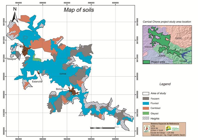
In Table 2 is shown area distribution that GRS and US occupy.
Table 2 Distribution and area that occupy the different Referencial Groups and the Soil Units of Carrizal-Chone system, Manabí, Ecuador
| Soil referencial group | Area in ha | Soil unit | Area in ha | % of GRS |
|---|---|---|---|---|
| Feozems | 2107.6(29 % of the total area) | Feozem fluvic | 1098.5 | 52 |
| Feozem fluvic. cambic | 848.2 | 40 | ||
| Feozem fluvic. gleyic | 160.9 | 8 | ||
| Fluvisols | 3787.8(53 % of the total area) | Fluvisol eutric | 2506.5 | 66 |
| Fluvisol eutric. ocric | 792.9 | 21 | ||
| Fluvisol eutric. protovertic | 192.6 | 5 | ||
| Fluvisol gleyic. eutric | 21.1 | 1 | ||
| Fluvisol gleyic. eutric. ocric | 191.9 | 5 | ||
| Fluvisol gleyic. eutric. protovertic | 82.8 | 3 | ||
| Cambisols | 1036.9(14 % of the total area) | Cambisol fluvic. eutric | 42.1 | 4 |
| Cambisol fluvic. vertic. eutric | 261.8 | 25 | ||
| Cambisol fluvic. vértico. eutric. ocric | 139.2 | 13 | ||
| Cambisol fluvic. gleyic. eutric | 31.2 | 3 | ||
| Cambisol fluvic. gleyic. vertic. eutric | 234.6 | 23 | ||
| Cambisol fluvic. estagnic. vértico. eutric | 328.0 | 32 | ||
| Gleysols | 301.4(4 % of the total area) | Gleysol fluvic. eutric | 301.4 | 100 |
| TOTAL | 7233.7 | 7233.7 | 100 |
Soil characteristics
For the characterization of soils it is very important to study the profiles due to the classification adopted, World Reference Base 12. The morphology of the profiles is necessary, since this classification is based on the genesis of the soils and on horizons and diagnostic characteristics. This is very important for any soil classification system that is based on horizons and diagnostic characteristics in relation to the genesis of soils, such as the classification of soils of Russia 20 and that of Cuba (8; Therefore, the following has been expressed in recent studies, in recent soil classification systems, based on horizons and their diagnostic characteristics in relation to soil genesis, the priority of morphological studies is obvious , while soil formation factors and analytical data, are weakly included in soil identification 21.
According to the classification adopted in this work, of the World Reference Base, version 2014 12, Fluvisols and Feozems are diagnosed by:
Feozems
They are dark colored soils, comprising an extension of 2107.6 ha (29 % of the total). These soils do not have the characteristics of Fluvisols and are diagnosed by having a surface mollic horizon, which is present when the soil has a good structure; they are usually nuciform and granular or of subangular blocks that crumble into nuciform and granular, dark color with value and dry chroma not greater than 5 and wet not greater than 2.5 and also a thickness of at least 18 cm and a degree of saturation greater than 50 %, therefore all are Eutric ones which is not among the GRS qualifiers.
The data of a Feozem soil are presented in Table 3, 4 and 55.
Table 3 Mechanical composition and soil texture of the Feozems of the Carrizal-Chone System, Manabí, Ecuador
| Horizons | Depth cm | Sand% | Slime% | Clay% | Texture |
|---|---|---|---|---|---|
| IA | 0-70 | 31.20 | 8.00 | 60.80 | clay |
| IIC | 70-110 | 77.60 | 19.20 | 3.20 | sand-loam |
| IIIC | 110-150 | 40.00 | 44.00 | 16.00 | Sand-frank |
Table 4 Some chemical properties of the Feozems soil of the Carrizal-Chone System, Manabí, Ecuador
| Horizons | Depthcm | pHH2O | M.O.(%) | CE dS/m |
|---|---|---|---|---|
| IA | 0-70 | 5.93 | 2.3 | 0.223 |
| IIC | 70-110 | 6.27 | 0.5 | 0.001 |
| IIIC | 110-150 | 6.44 | 1.5 | 0.002 |
Table 5 Content in organic matter and reserves of CO from soil of Feozems of Carrizal-Chone system, Manabí, Ecuador
| Horizons | Depthcm | MO% | C% | DvMg m3 | RCOMg ha-1 | RCO Mg ha-10-30 0-50 0-100 |
| IA | 0-70 | 2.3 | 1.33 | 1.14 | 106.46 | 46 76 118 |
| IIC | 70-110 | 0.5 | 0.29 | 1.24 | 14.38 | |
| IIIC | 110-150 | 1.5 | 0.87 | 1.29 | 44.89 |
The GRS of the Feozems, presents the following Soil Units (the Soil Unit is formed by the GRS with the qualifiers or properties that they may have). The following Soil Units are presented on the soil map (Figure 1):
Feozem fluvic
This Feozem is characterized by having a mollic A profile, generally with a frank texture, on mollic materials with a sandy texture; that is to say, it is a profile of type A-C. They occupy an area of 1098.5 ha; 52 % of the Feozems area.
The fluvial material is of river, marine or lake origin and is identified by the stratification of mineral particles, or the irregular distribution of organic matter or both by profile, in the first 50 cm of the upper soil thickness.
Cambic fluvic Feozem
It is a Feozem soil also formed of fluvic materials, but with a Cambic B horizon. It is a soil that has a mollic A horizon, with a Cambic B, formed of river materials. It has an area of 848 hectares (40 % of the Feozems area).
The cambic qualifier is when the Feozem has a horizon B; that is, the profile is not A-C; but A-B-C.
Gleyic fluvic Feozem
Feozem formed of fluvial materials, but which has a presence of gleyic properties below 50 m deep, often with a water table present 100-120 cm deep. Within the GRS it is the most bad drainage, and has an extension of 161 ha; 8 % of the Fluvisols area.
The gleyic properties correspond to the gleyzation process:
1. 90 percent or more reductimorphic colors comprising white to black, or bluish to greenish, or
2. 5 percent or more mottled redoximorphic colors (yellow, red, and gray).
Fluvisols
They are soils formed by river sediments, which are diagnosed by having materials differentiated by mechanical particles (sand, silt and clay) or by presenting differences in organic matter content at a depth of less than 25 cm measured from the surface. They are AC profile without a mollic A horizon, nor a cambic B horizon. They have an area of 3787.7 hectares; which represents 53 % of the total. The characteristics of a Fluvisol profile are presented in Tables 6, Tables 7 and Tables 8.
Table 6 Mechanical composition and soil texture of the Fluvisol of the Carrizal-Chone System, Manabí, Ecuador
| Horizons | Depth cm | Sand% | Slime% | Clay% | Texture |
|---|---|---|---|---|---|
| IA | 0-40 | 41.60 | 36.00 | 22.40 | frank |
| IIC11 | 40-68 | 68.00 | 28.00 | 4.00 | sandy loam |
| IIC12 | 68-108 | 68.80 | 28.00 | 3.20 | sandy loam |
| IIIC | 108-150 | 52.00 | 34.40 | 13.60 | frank |
Table 7 Some chemical properties of the Fluvisol soil of the Carrizal-Chone System, Manabí, Ecuador
| Horizons | Depthcm | pHH2O | M.O.(%) | P2O5AssimMg 100 g-1 | K2OAssimMg 100 g-1 | Ca Mg K Na Sum Cmol (+) kg-1 | CE Ds m-1 |
|---|---|---|---|---|---|---|---|
| IA | 0-40 | 6.98 | 2.1 | 10.8 | 45.4 | 16.0 5.4 0.97 Nd 22.37 | 0.04 |
| IIC11 | 40-68 | 7.57 | 0.5 | 5.3 | 35.1 | 16.0 5.3 0.75 Nd 22.05 | 0.05 |
| IIC12 | 68-108 | 6.98 | 0.2 | 4.1 | 26.7 | 17.0 4.7 0.57 Nd 22.27 | 0.08 |
| IIIC | 108-150 | 6.79 | 0.5 | 4.1 | 27.1 | 17.0 4.9 0.58 Nd 22.48 | 0.11 |
Table 8 Content in organic matter and CO reserves from Fluvisol soil of Carrizal-Chone system, Manabí, Ecuador
| Horizon | Depthcm | MO% | C% | DvMg m3 | RCOMg ha-1 | RCO Mg ha-10-30 0-50 0-100 |
|---|---|---|---|---|---|---|
| IA | 0-40 | 2.1 | 1.22 | 1.38 | 67.24 | 50 71 82 |
| IIC11 | 40-68 | 0.5 | 0.29 | 1.19 | 9.66 | |
| IIC12 | 68-108 | 0.2 | 0.12 | 1.32 | 6.13 | |
| IIIC | 108-150 | 0.5 | 0.29 | 1.03 | 12.55 |
The soil Units present are the following:
Eutric fluvisol
They are Fuvisols that have more than 50 % base saturation at a thickness of 1 meter, measured from the surface. The area it occupies is 2506 hectares; 66 % of the Fluvisols. The éutrico character is given when the soil has a degree of saturation by bases of 50 % or more.
Eutric and ocric fluvisol
Fluvisols that have more than 50 base saturation, but have a very low organic matter content (equal to or less than 1 %). They have an extension of 793 ha, 21 % of the Fluvisols. The qualifier is placed when the soil has a mineral surface horizon that is ≥ 10 cm thick, with ≥ 0.2 and <0.6 % organic carbon (on average). Actually these values correspond to equal or less than 1% of organic matter.
Eutric and protovertic fluvisol
These are eutronic fluvisols that have thick aggregates at the top of the profile, they are an initial stage of formation of Vertisols from the Fluvisols. They are clayey and with poor drainage inside the Fluvisols. They have an extension of 193 ha; 5 % only of Fluvisols. The qualifier proto-desert in the Fluvisols is set when the soil has a horizon that has the same properties as the vertic horizon but has very few slickensides or is absent and the prismatic blocks are equal to or less than 15 cm in size.
Fluvisol gleyic and eutric
This is eutrophic Fluvisol that has glyphic properties below 50 cm, usually with a water table between 80 and 120 cm deep measured from the surface. It has an area of 21 hectares; only 1 % of the Fluvisol area.
Fluvisol gleyic, eutric and ocric
It is a gleyic and eutric Fluvisol, but it has an organic matter content on horizon A, which most often corresponds to a content equal to or less than 1 %, this Soil Unit within the study area has an extension of 191, 9 hectares. Profile 97 is representative of this soil.
Fluvisol gleyic, eutric and protovertic
They are Fluvisols that have even worse drainage than the Gleyic Fluvisols and the Protovertic ones, since they combine the presence of a water table around the depth meter and also clay texture with thick aggregates, with a large and medium block structure on the surface It has an extension of only 83 ha.
Cambisols
Their formation is not natural within the study region, they are formed by the degradation of the Cambic Feozems. For this reason they are lighter colored soils than the Feozems and presence of a cambic B horizon. In Tables 9, 10 and 11, there are the data that characterize this GRS.
Table 9 Mechanical composition and soil texture of Cambisol from the Carrizal-Chone System, Manabí, Ecuador
| Horizons | Depthcm | Sand% | Slime% | Clay% | Texture |
|---|---|---|---|---|---|
| IA | 0-32 | 44.00 | 45.60 | 10.40 | frank |
| IB | 32-68 | 42.00 | 47.60 | 10.40 | frank |
| IIC11 | 68-100 | 45.60 | 49.60 | 4.80 | sandy loam |
| IIC12 | 100-130 | 46.40 | 49.60 | 4.00 | sandy loam |
Table 10 Some chemical properties of the Cambisol soil of the Carrizal-Chone System, Manabí, Ecuador
| Horizons | Depthcm | pHH2O | M.O.(%) | CE dS/m |
|---|---|---|---|---|
| IA | 0-32 | 6.90 | 2.7 | 0.278 |
| IB | 32-68 | 6.68 | 0.5 | 0.097 |
| IIC11 | 68-100 | 6.32 | 0.2 | 0.334 |
| IIC12 | 100-130 | 6.43 | 0.5 | 0.115 |
Table 11 Organic matter content and CO reserves of the Cambisol soil of the Carrizal-Chone System, Manabí, Ecuador
| Horizon | Depthcm | MO% | CO% | DvMg m3 | RCOMg ha-1 | RCO Mg ha-10-30 0-50 0-100 |
|---|---|---|---|---|---|---|
| IA | 0-32 | 2.7 | 1.57 | 1.28 | 64.15 | 60 71 82 |
| IB | 32-68 | 0.5 | 0.29 | 1.28 | 13.36 | |
| IIC11 | 68-100 | 0.2 | 0.12 | 1.22 | 4.53 | |
| IIC12 | 100-130 | 0.5 | 0.29 | 1.23 | 10.70 |
The Soil Units presented are very varied, among them we have:
Fluvic and eutric Cambisol
They are Cambisols that have fluvial materials and more than 50 % base saturation up to one meter of depth measured from the surface. It has an extension of only 42 ha.
Fluvic, vertical, and eutric Cambisol
This Unit of Soil is classified when the fluvial Cambisols soils have vertic characteristics and also have more than 50 % base saturation. They occupy an area of 262 ha.
Fluvic, vertic, eutric and ocric Cambisol
It is the soil of the previous US, but it has a content equal to or less than 1 % of organic matter. It has an extension of 139 ha.
Fluvic, gleyic, vertic and eutric Cambisol
Cambisols result in worse drainage within the Soil Reference Group, it is formed of fluvial materials, has 50 % or more base saturation, but has vertic and glyceic properties, usually with a water table between 1-1.20 depth meter They have an extension of 235 ha.
Fluvic, gleyic and eutric Cambisol
They are Cambisols that also have glyphic properties, therefore with poor drainage, but without the vertic properties. They comprise an extension of 31 ha only.
Stagnic, fluvic, vertical and eutric Cambisol
They are stagnic, fluvic and eutric Cambisols of clayey texture, which have a thick structure in the form of prismatic aggregates that can be up to 15-20 cm in size, usually in the first 50 m of the upper part of the profile. Pressure cutanes or slickensides are absent or very small, so that the soil can be classified as Vertisol. They have an extension of 328 ha.
Gleysols
In addition to the previous GRS, in some depressive parts a water table can develop, which causes oxidation-reduction phenomena according to the oscillation of the mantle in relation to the periods of rain and drought, giving rise to the soil formation process called gleyzation. When this mantle is at a depth of 50 cm or closer to the soil surface, the soil is classified as Gleysol. Only the fluvic and eutric Gleysol is separated from the soil map, which results in a Gleysol that has a base saturation percentage equal to or greater than 50 % and formed from fluvial materials. It occupies an area of 300 ha.
Tables 12, Tables 13 and Tables 14 show the characteristics of a profile of this GRS that has a water freactic 40 cm from the ground surface
Table 12 Mechanical composition and soil texture of Gleysol from the Carrizal-Chone System, Manabí, Ecuador
| Horizons | Depthcm. | Sand% | Slime% | Clay% | Texture |
|---|---|---|---|---|---|
| A | 0-40 | 20.00 | 46.40 | 33.60 | franko-limo-arcillosa |
Table 13 Some chemical properties of the Gleysol soil of the Carrizal-Chone System, Manabí, Ecuador
| Horizon | Depth cm. | pHH2O | M.O (%) | CE dS/m |
|---|---|---|---|---|
| A | 0-40 | 7.58 | 2.3 | 0.08 |
Table 14 Organic matter content and CO reserves of the Gleysol soil of the Carrizal-Chone System, Manabí, Ecuador
| Horizon | Depthcm | M.O.% | C% | DvMg/m3 | RCOMg/ha | RCO Mg ha-10-30 0-50 0-100 |
|---|---|---|---|---|---|---|
| A | 0-40 | 2.3 | 1.33 | 0.94 | 50.16 | 38 63 125 |
With the completion of the elaboration of the soil map, valuable information is obtained on the soils, the distribution laws, the surface they occupy, their limiting factors, the response to their characteristics, including the anthropogenic factor, which is a current aspect. Based on these results, important recommendations for soil management are developed.
However, considering the current problem of degradation of soil properties, its possible improvement through the application of organic enhancers and biofertilizers, with or without fertilizers, which allow obtaining good yields but improving or at least preventing soil deterioration; it is necessary, as mentioned above, to create Sectors and Reference Plots.
Sectors and Reference Plots are technologies that combine the study of the characteristics and evolution of soil properties and their management, based on advanced techniques such as the implementation of Geographic Information Systems 22.
These technologies are known from studies conducted by French edaphologists 23,24 applied in relatively shallow areas (less than 1000 ha) and that represent a small unit of a representative landscape (geographic region), based on a Large-scale soil map (1:25,000; 1:50,000), to search for sustainable management technologies.
In the chosen sector, it is necessary to carry out a topographic survey and this plan is taken as the basis for mapping soils on a detailed scale (1:10 000 or more detailed, in relation to the selected area).
The cartographic survey of the soils must be done walking, with the help of a compass or a theodolite, with fixed transept, separated from each other according to the selected scale. Surveys are carried out with the soil auger and with the implementation of previously prepared forms, the soils are classified and the agroproductive limiting factors are predetermined, as well as the characteristics of the area, climate, relief, vegetation, etc. are recorded.
For the Carrizal-Chone System, two Reference Sectors (SR) and a Reference Plot (PR) are selected. The SR must be one for the area of Calceta and another entity Estancilla and Tosagua; the PR must be established in the part between Calceta and La Estancilla.
The contours of separate soils in the different SRs, serve as a basis to look for sustainable management technologies, for degraded soils, mainly Cambisols, with the test of organic and biological improvers, with and without mineral fertilizers.
With the corresponding monitoring of crop yields and soil properties, sustainable management technologies will come out for this region for degraded soils and better soils.
Furthermore, on the basis of the results obtained in the carbon stock map, the carbon gain or loss in t C ha-1 year-1 begins to be established through soil monitoring. For example, how much contribute per year in carbon reserves does the teak grove or the combination of grove with guava and coffee, plantation of cocoa, bananas. This always taking into account the climatic conditions and the soil.
These results really exist today in developed countries of temperate climate, which are those that have resources to carry out these investigations. They would be the first obtained in Manabí and possibly throughout Ecuador. The results obtained will serve to propose a carbon sequestration and carbon sequestration policy in the region, which can serve the regional and provincial authorities for climate change mitigation policy.
CONCLUSIONS
The study of the cartography and classification of the soils of the Carrizal-Chone System is carried out, with the preparation of the soil map. In addition, it is confirmed that there are four Reference Groups (Feozems, Fluvisols, Cambisols and Gleysols) with 16 Soil Units.
The most extensive soil is Fluvisol, while the best agro-productive characteristics are Feozems.
Cambisol is a soil formed by degradation of Feozems.
On the basis of the work carried out, the establishment of two Reference Sectors and a Reference Plot is selected, for the search of sustainable soil management with food production
BIBLIOGRAFIA
1. Achouri M. Los suelos sanos son la base de la producción alimentaria [Internet]. Berlin: Organización de las Naciones Unidas para la Alimentación y la Agricultura (FAO); 2015 [cited 2019 Mar 28] p. 1. Available from: http://www.fao.org/news/story/es/item/284228/icode/1. [ Links ]
2. FAO. Los suelos sanos son la base para la producción de alimentos saludables [Internet]. Roma, Italia: Organización de las Naciones Unidas para la Alimentación y la Agricultura (FAO); 2015 p. 4. Report No.: 4405s/1/02.15. Available from: http://www.fao.org/3/a-i4405s.pdf2. [ Links ]
3. FAO. Suelos y biodiversidad: Los suelos albergan una cuarta parte de la biodiversidad de nuestro planeta [Internet]. Roma, Italia: Organización de las Naciones Unidas para la Alimentación y la Agricultura (FAO); 2015 p. 4. Report No.: 4405s/1/02.15. Available from: http://www.fao.org/3/a-i4405s.pdf3. [ Links ]
4. Hernández A, Vera L, Naveda CA, Monserrate Á, Vivar M, Zambrano TR, et al. Tipos de suelos y sus características de las partes medias y bajas de la microcuenca Membrillo, Manabí, Ecuador. Revista ESPAMCIENCIA. 2012;3(3):87-97. [ Links ]
5. Hernández A, Vera L, Basurto N, Alfredo C, Cedeño G, Monserrate Á, et al. Variaciones en algunas propiedades del suelo por el cambio de uso de la tierra, en las partes media y baja de la microcuenca Membrillo, Manabí, Ecuador. Cultivos Tropicales. 2017;38(1):50-6. [ Links ]
6. Vera L. Estudio de los suelos y su fertilidad como base para el manejo sostenible del Campus de la Escuela Superior Politécnica Agropecuaria de Manabí, Ecuador [Tesis de Maestría]. [Mayabeque, Cuba]: Instituto Nacional de Ciencias Agrícolas; 2013. 67 p. [ Links ]
7. Mata R, Sandoval D, Castro J, Solís C. Buenas prácticas en la elaboración en mapas de suelo [Internet]. San José, Costa Rica: Instituto Interamericano de Cooperación para la Agricultura. Centro de Investigaciones Agronómicas; 2016. 19 p. Available from: http://repiica.iica.int/docs/B4062e/B4062e.pdf7. [ Links ]
8. Hernández Jiménez A, Pérez J, Bosch D, Castro N. Clasificación de los suelos de Cuba. Mayabeque, Cuba: Ediciones INCA; 2015. 93 p. [ Links ]
9. Vera L, Hernández A, Mesías F, Guzman A, Cedeño Á. Manual para la cartografía de suelos y la descripción de perfiles de suelos. (Adaptado a las características de los suelos de la parte central norte de la Costa de Manabí). 1st ed. Calceta, Ecuador: Editorial Humus, Escuela Superior Politécnica Agropecuaria de Manabí Manuel Félix López; 2017. 70 p. [ Links ]
10. Walkley A, Black IA. An examination of the degtjareff method for determining soil organic matter, and a proposed modification of the chromic acid titration method: Soil Science. 1934;37(1):29-38. doi:10.1097/00010694-193401000-00003 [ Links ]
11. Munsell Book of Soil Color Charts [Internet]. Francia: APPAREIL; 2009 [cited 2019 Apr 1] p. 25. Available from: http://www.verivide.com/product/-munsell-book-of-soil-color-charts-2009-rev [ Links ]
12. FAO and IUSS. World reference base for soil resources 2014 [Internet]. Rome: FAO; 2015 [cited 2018 Apr 4]. 203 p. (Reports No. 106.). Available from: www.fao.org/3/i3794en/I3794EN.pdf [ Links ]
13. Gardi C, Angelini M, Barceló S, Comerma J, Cruz C, Encina A, et al. Atlas de suelos de América Latina y el Caribe [Internet]. Luxembourgo: Comisión Europea - Oficina de Publicaciones de la Unión Europea, L-2995; 2014. 176 p. Available from: https://www.gpgservicesec.com/download/libros/ATLAS-DE-SUELOS-LATINOAMERICA-Y-EL-CARIBE.pdf13. [ Links ]
14. Guerasimova M, Stroganova M, Mosharova N, Prokofieva T. Suelos Antropogénicos, Génesis, Geografía, Recultivación. Manual de Estudio (en ruso). Bajo la redacción del Académico G.V. Dobrovolskii. Smolensk, Oikumena; 2003. 268 p. [ Links ]
15. Hernández A, Moreno I. Características y clasificación de los suelos cultivados de arroz en La Palma, Pinar del Río. Cultivos Tropicales. 2010;31(2):37-47. [ Links ]
16. González L, Acosta M, Carrillo F, Báez A, González JM. Cambios de carbono orgánico del suelo bajo escenarios de cambio de uso de suelo en México. Revista mexicana de ciencias agrícolas. 2014;5(7):1275-85. [ Links ]
17. Fernández ML, Lozano B, Parras L. Topography and land use change effects on the soil organic carbon stock of forest soils in Mediterranean natural areas. Agriculture, Ecosystems & Environment. 2014;195:1-9. doi:10.1016/j.agee.2014.05.015 [ Links ]
18. Hernández A, Morales M, Borges Y, Vargas D, Cabrera JA, Ascanio MO, et al. Degradación de las propiedades de los suelos Ferralíticos Rojos Lixiviados de la Llanura Roja de La Habana, por el cultivo continuado. Algunos resultados sobre su mejoramiento. San José de las Lajas, Mayabeque, Cuba: Ediciones INCA; 2014. 156 p. [ Links ]
19. Hernández A, Vargas D, Bojórquez JI, García JD, Madueño A, Morales M. Carbon losses and soil property changes in ferralic Nitisols from Cuba under different coverages. Scientia Agricola. 2017;74(4):311-6. doi:10.1590/1678-992x-2016-0117 [ Links ]
20. Shishov LL, Tonkonogov VD, Lebedeva II, Guerasimova MI. Diagnóstico y Clasificación de Suelos de Rusia (en ruso). Moscú, Rusia: Oikumena; 2004. 341 p. [ Links ]
21. Gerasimova МI, Khitrov NB. Morphological soil description for classifying soils and interpteting their genesis. Byulleten Pochvennogo insti-tuta im. V.V. Dokuchaeva. 2016;86:8-16. doi: 10.19047/0136-16942016-86-8-16 [ Links ]
22. Hernández Jiménez A, Ascanio M, Morales M, Bojórquez JI, García N, García JD. El suelo: fundamentos sobre su formación, los cambios globales y su manejo. 1ra ed. Tepic, Nayarit; México: Universidad Autónoma de Nayarit; 2006. 255 p. [ Links ]
23. Favrot J. Cahier des Clauses Technicques Generales pour la realisation de l´etude pedologique d´un Secteur de Reference. In: Programme IGCS. Paris: Ministere de la Agriculture; 1991. p. 11. [ Links ]
24. Favrot JC, Bouziques R. Les Etudes Pedologiques Prealables au Drainage Agricole. CEMAGREF. 1994;(283-284):39-56. [ Links ]
Received: November 29, 2017; Accepted: January 31, 2019

