


Mi SciELO
 Servicios personalizados
Servicios Personalizados
Articulo
 texto en
  Inglés (pdf)
 Articulo en XML
 Referencias del artículo
 Enviar articulo por email
Indicadores
-
 Citado por SciELO
Links relacionados
-
 Similares en
SciELO
Similares en
SciELO
Compartir

 Permalink
EduSol
versión On-line ISSN 1729-8091
EduSol vol.23 no.84 Guantánamo jul.-set. 2023 Epub 10-Jul-2023
Original article
Model of didactic itinerary for the training of Geography teachers in Cuban Pedagogical Schools
1Universidad Central “Marta Abreu” de Las Villas
In Cuba, didactic itineraries have been little systematized and approached from the theoretical and practical point of view. In this sense, a model of didactic itinerary is proposed for the training of Geography teachers in Pedagogical Schools. Methods and techniques such as: observation, interview, focal group and memos were applied. This proposal contributed to develop professional pedagogical skills, to systematize geographic knowledge and to assume adequate behavioral norms. This is consistent with the assumptions of Education for Sustainable Development.
Key words: Education for Sustainable Development; Didactic itinerary; Geography; Teacher Training
Introduction
The processes of improvement of the educational system in Cuba has been aimed at raising the quality of education and has become a purpose of systematic and progressive work at various times of historical development, which takes into account the scientific and technological advances to put man at the level of his time.
In this direction, priority has been given to the process of teacher training in the Pedagogical Schools, in which specialties such as Geography have been included in response to the enormous needs of society and to guarantee the social scope of essential potentialities for the development of the country.
Associated with the above, the training of Geography teachers is integrated by a system of sciences that cover the study of the physical-geographical and economic-geographical components, concretized in the landscape, which constitutes the main scenario of Geography, by means of field study, direct observation, field work, geographical excursion and the didactic itinerary, which favors its learning.
The didactic itinerary is defined as the routes with teaching purposes that a person or group of people makes towards a determined direction, it can be open or closed and where there are different points of didactic interest for the teaching of educational and instructive objectives (Bosques, 2004, p. 221).
Therefore, it is necessary to enhance the study of Geography, starting from landscapes as an essential element in the analysis of geographical phenomena for the appropriation of knowledge, the development of skills and modes of action, due to the interaction of human beings with the environment where they live and what it contributes to the training of teachers.
From this direction, the didactic itinerary, in the training of Geography teachers in Pedagogical Schools, offers possibilities for Education for Sustainable Development, (ESD), through the study of landscapes in a real or virtual way and at different global, regional or local scales and for the growing interest in perfecting the training of education professionals, which has been experienced internationally and from which Cuba is not exempt.
It is noteworthy that in Cuba, didactic itineraries have been little systematized, little approached from the theoretical and practical point of view; most of the research suggests outings outside the classroom through the teacher's excursion, while the itinerary is identified as an element of its preparation and the contributions related to the study of geographic space at different regional or global scales are limited. The following studies on the subject stand out: Bosque (2004), which defines this term and presents the methodological procedures for its design.
If it is taken into account that there is a need for improvement in the training of Geography teachers, it is necessary to look for other ways to facilitate the assimilation of knowledge, skills and attitudes, based on the study of different geographic spaces; however, the solutions proposed by science in Cuban Pedagogical Schools are considered insufficient.
Consequently, in view of the challenges of ESD, the use of didactic itineraries can contribute to the training of Geography teachers in Pedagogical Schools, so that the assimilation of knowledge, attitudes and professional pedagogical skills is favored, by promoting the study of the landscape in an integral way and at different scales, with the use of varied learning environments.
The objective of the article is to present a model of didactic itinerary for the training of Geography teachers in Pedagogical Schools, which facilitates their incorporation to the training process aligned to Education for Sustainable Development.
Development
The International Geographical Union (IGU), in its international declarations, expresses the need for a Geography aimed at enhancing knowledge of the environment close to the society where one lives, that there should be a balance in the scale of geographical analysis: local, regional, national or global, and that it is essential that students exercise and develop geographical skills aimed at finding solutions to the problems posed in the organization of space, present and future (IGU, 1992).
In this sense, they refer to prioritizing topics that affect ecological-holistic thinking and focus on the contribution of Geography to ESD, as it contributes to improving the understanding of ESD by developing its curriculum, incorporating Information and Communication Technologies (ICTs) and the link with the acquisition of geographic competencies (IGU, 2007).
The same statement highlights the three competency domains: knowledge, skills and attitudes, expressed through geographic knowledge and understanding of natural systems, the interaction between ecosystems and socioeconomic systems and helps students to understand the world through key geographic concepts such as location, distribution, distance, movement, region, scale, spatial association, spatial interaction and change over time; work on communication skills, reasoning and practical and social skills help to explore geographic issues at a range of levels from local to international. The development of attitudes and values to seek solutions to local, regional, national and international questions and problems based on the Universal Declaration of Human Rights (IGU, 2007).
Therefore, Geography must be able to explain the diversity of existing spaces, the territorial and social inequalities that exist on the planet and within countries or nations themselves, the effects that human action is having on Nature and the environment and the causes that motivate them, and try to provide solutions. Only by being aware of the impact of globalization phenomena can we have a more accurate picture of what is happening in the near and distant environment (Marrón, 2007).
Taking into account the above considerations, the challenge in Geography proposals implies the inclusion of new ways of understanding space in order to bring students closer to theoretical advances. Geography must contribute a new conceptualization of space and approach other Geographies to include other topics that give meaning to the study of the relationships of social groups with their environment. Thus, paying attention to themes with a perspective of analysis that highlights concepts of the invisible, the intangible and the ephemeral in Geography, considered marginal in traditional studies; that is, the temporal dimension in the study of any process (Nogué & Romero, 2006).
Associated with the above, Professor García (2009) refers that this knowledge contributes to the formation of critical citizens. This is what ESD aims at, which seeks to raise awareness of the current situation, environmental improvement, social development and sustainable economy and aims to combine a way forward by seeking the best balance between the different forces. This is a requirement for the training of future teachers.
Taking into account the above, it is considered that the forms used in the training of Geography teachers in Cuban Pedagogical Schools should assume the following characteristics:
The study of geographic space at different scales: global, regional and local.
Incorporate knowledge of other geographies where the invisible, the intangible and the ephemeral are taken into account.
The use of information and communication technologies is promoted.
The contents are studied holistically to contribute to ESD.
Contribute to the solution of problems of the society where they live.
Contribute to the development of professional competencies: in its three areas: knowledge, skills, and attitudes.
New ways of understanding space are included to bring students closer to theoretical advances.
As a consequence, the proposed model is a formal theoretical construction: it interprets designs and coincides with the pedagogical reality, which, scientifically and ideologically based, responds to an educational need in correspondence with social demands.
The model as a scientific result in the educational sector is necessary to enrich the theory and transform the pedagogical practice; it fulfills a heuristic function; it allows discovering and studying new relations, qualities of the studied object, at the same time it reveals, the nature of the object that is modeled and the theoretical-methodological positions that facilitate its instrumentation. It arises from the study of the object and is therefore not its original copy. The researcher describes and represents, to a certain degree, the structure, functioning and state of the object.
In the study carried out on the definition of model, different authors coincide in stating that it constitutes a simplified representation of reality, it is an interpretative scheme that fulfills a purpose in the scientific field and is not definitive. It resembles the original object and reflects its main characteristics, relations, structures, properties; a concept that is assumed (Stoff, 1980; Pérez, et. al., 1996).
The proposal of the didactic itinerary model for the training of Geography teachers in Cuban Pedagogical Schools, arises from the analysis and processing of the data obtained as a result of the application of diagnostic instruments to 39 students in training, who study the specialty: participant observation, in-depth interview and focus group, which allowed determining insufficiencies in:
The interpretation of the physical elements of the landscape in an integral way.
The establishment of relationships between the natural and social components of the geographic space.
In the development of cartographic, general and specific intellectual skills.
In the search for solutions to environmental problems.
Inadequate standards of social behavior.
When processing information, working with the basic and complementary bibliography of the specialty and with other sources of information.
In the search for individual and group learning strategies.
In the independence to develop study skills.
The results show the insufficiencies in the training of Geography teachers in Cuban Pedagogical Schools, which agree with the three competence areas for a professional in this discipline: cognitive, procedural and attitudinal, assumed by the International Geographical Union.
It can be concluded by stating that the training of Geography teachers in Cuban Pedagogical Schools should be in correspondence with the concrete needs of the historical moment and make possible the adequate training to exercise teaching; for the determining role it plays in the formation of future generations, for its integrating approach with other sciences, for its contribution to the personality and knowledge of students and its contribution to sustainable development.
In correspondence with the above, since ancient times, the need for the education of man in connection with nature is emphasized, as a fundamental means of intellectual development of students, which provides them with the necessary knowledge, prepares them for their practical activity and emphasizes the need to produce interest in students for teaching to be fruitful.
To this can be added that the emergence and development of excursions for recreational and educational purposes should guarantee the abandonment of academicism in favor of activity and experimentation. The need to teach to think about everything around him, to turn the student into a cultivable field and not a warehouse, to see before knowing and to promote the value of travel over many lessons.
Then, activities outside the classroom are related as a method for the active observation of the environment, the teaching of the global reality is promoted, the school is conceived as a space for the production and reflection of relevant experiences of social life, which stimulates the realization of classes-walks or didactic itineraries, focused on the interpretation of the landscape and for the training of teachers.
A didactic itinerary, according to Bosque (2004) is a tour with teaching purposes (...) where there are several didactic points of interest for teaching formative and instructive objectives (p. 221). For Liceras (2018) are those activities that the teacher performs with his students in the field (p. 4). While for Álvarez & Hernández (2021) express that they are resources that involve changing the classroom for the outside world, to interact with reality (...) that constitute a proposal regarding the way of organizing and scripting teaching (p. 321).
In this sense, the authors of this research consider didactic itineraries as: a route for teaching purposes, where activities are carried out in the field, which can be in landscapes of the objective reality or in virtual representations of the objective reality at different scales (local, regional or global) for the teaching of knowledge, attitudes and professional pedagogical skills that constitute a form of teaching organization for the training of Geography teachers.
According to Bosque (2004): the following requirements for its use should also be kept in mind:
Avoid excessive stops.
Avoid long distances.
Avoid places with heavy traffic or noise.
The selected resources should be significant and have the greatest possible visibility of the phenomena or processes to be studied.
The didactic itinerary is of great importance in the training of Geography teachers as it is an essential didactic resource in the study and development of learning about the social, cultural, patrimonial and historical reality, and it is an active methodological strategy that favors the development of values and competences, enhanced from collaborative work (Liceras, 2018, p. 71).
The didactic itinerary presents advantages for students in training: the development of communicative skills, of perception and observation of the landscape; the understanding of basic concepts and the verification of concrete facts; of procedural skills, self-esteem and self-confidence by achieving positive results and being protagonists of the activity. Learning takes place in an autonomous and progressive way, interdisciplinarity, in a critical, responsible and participative spirit, grasping reality in an integrated way, direct observation of the objects of study, comparison, cartographic skills and an environmental perspective on the surroundings that can propitiate the search for solutions to environmental problems.
The model is specified from two presupposed perspectives: structural and functional. The structural perspective is aimed at explaining the model in its static dimension and from this particular point of view it can be seen as the integration of a system of components that articulate among themselves, making possible the training of Geography teachers in Cuban Pedagogical Schools.
According to these particularities, the components of the model are the following: planning, preparation and comprehensive evaluation. (Figure 1 Graphical representation of the model).
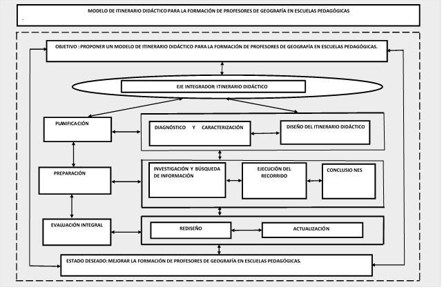
The phases of each of its components respond to an interrelation that integrates the dynamics and functionality projected in the model through the hierarchical and subordinate actions that offer integrality to the training of Geography teachers in Cuban Pedagogical Schools.
Necessary explanation of each of the components.
Planning. It consists of identifying the potentialities and weaknesses of the students in training from the application of different diagnostic instruments that make possible the design of a didactic itinerary for the training of Geography teachers in Cuban Pedagogical Schools.
Diagnosis and characterization. It consists of applying different diagnostic instruments that make it possible to determine the potentialities and weaknesses of the students in training in order to identify the traits that characterize them.
Design of the didactic itinerary. It consists of designing the didactic itinerary, evaluating it in the year and department collective for its approval and insertion into the institutional curriculum. Research and seek information about the material resources and teaching aids available, as well as a previous study of possible landscapes to be studied during the didactic itinerary, by the teacher(s). Organize the material resources necessary for the activities, taking into account the resources available. To design the possible activities to be carried out during each of the stages of the didactic itinerary, as well as the aspects to be evaluated in each one.
Preparation. It consists of the realization of the didactic itinerary taking into consideration the motivation, organization of the students in study teams, evaluation, orientation, background knowledge, landscapes to be studied, goals to be improved, information search and scientific research activities and the bibliography to be used.
Research and information search. It consists of presenting the results obtained by the students, contrasting and comparing the regularities of the phenomenon under study in different contexts, outlining the itinerary to be followed together with their teacher. Define the didactic potentialities, the procedures used, the skills developed, the attitudes, feelings and values reinforced during the research. To elaborate the observation guide for the itinerary to be developed. Assess and evaluate the results, the goals to be proposed, elaborate a portfolio or dossier with the information gathered and guide the worksheet.
Execution of the route. It consists of describing and determining the most relevant elements of each landscape, reading the landscape, locating and locating the most outstanding elements, establishing the relationship between the components and determining the didactic principles of Geography, precision of the aesthetic, cultural, patrimonial and identity values of each landscape, the history and traces of history in the landscape. Specify the damages to the environment and propose actions to minimize them and their contribution to sustainable development. Establish interdisciplinary relationships. To understand, explain and value the causes of the processes and phenomena observed in each landscape, taking into account the ephemeral, invisible and intangible elements of each landscape and the route. Describe the feelings, make an analysis of the attitudes and human values strengthened. To compare the observation and perception of each landscape with the research carried out. To specify the regularities of the developed route, to determine and explain the most significant general skills for the students, professionals, cartographic teachers and didactic procedures that are approached during the execution of the performed activity, as well as the contribution to their formation. To carry out the integral evaluation of the studied landscapes and their possibilities for their later performance as basic secondary school teacher; as well as the didactic value of the route carried out. Assess and reflect on the evaluation and determine the goals.
Conclusions. It consists of evaluating the fulfillment of the objectives during the didactic itinerary developed. To reflect and recapitulate the experiences lived, the contributions of the itinerary to the integral formation of the students as future teachers of Geography for basic secondary education. Present the results obtained, make exhibitions or publications where the results are shown.
Integral evaluation. It is systematic and integrating, it constitutes a consistent vision of the model. It evaluates the internal structure, the coherence established between the objective of the model and its development, the adequacy to the environments, needs, possibilities, feasibility, the adjustments and the opening of new local social demands on the training of Geography teachers in Pedagogical Schools. It consists of assessing and reflecting on the evaluation and the goals achieved. Reflect on the main difficulties and achievements. To select the best works, students and teams. Evaluate students, integrally and individually.
. Redesign. It consists of the evaluation of each of the structural components and the flexibility offered by the model to modify or alter components or select different contents to adapt the didactic itinerary to the training of Geography teachers in Pedagogical Schools and adapt them according to the needs of the institutions and students.
Updating. As the process of training Geography teachers in Pedagogical Schools progresses, the components of the model are updated based on the transformations that have occurred.
Functional perspective of the model: it is a functional representation of a didactic itinerary for the training of Geography teachers in Pedagogical Schools, emphasizing the three competence areas: cognitive, procedural and attitudinal to assume its treatment from the value of the journey through different real or virtual, local, regional and global landscapes.
The implementation of the model is carried out in the schedule of complementary activities as part of the study plan for the training of Geography teachers in Cuban Pedagogical Schools, based on a program designed for this purpose.
Results of the application of the model.
After the proposal was applied, the memos were used as a research technique to collect the results obtained; in this sense, the development of intellectual, subject-specific, communicative, professional pedagogical, research and information search skills was reinforced in the students; They also learned to self-manage knowledge, made critical evaluations of their own work, assumed the evaluation as a process and not as a result, showed willingness for collaborative learning, appropriated the basic vocabulary of the subject, assumed appropriate standards of behavior, learned to set goals to be better people and professionals, showed willingness and satisfaction with the tasks. The above statements are consistent with the assumptions of Education for Sustainable Development.
Conclusions
The didactic itinerary model for the training of Geography teachers in Cuban Pedagogical Schools facilitates their incorporation into the training process, aligned with the ESD and as a response to the III Improvement of the National Education System. It promotes the systematization and deepening of geographic knowledge, the development of general, specific and professional pedagogical skills and strengthens values, feelings and positive attitudes in correspondence with the profession for which they are trained.
Referencias bibliográficas
Álvarez, J. & Hernández, J. (2021). Itinerarios didácticos con smartphones para promover la educación ambiental y la competencia digital entre el alumnado de secundaria. Digital Education Review, number 39. España: https://dialnet.unirioja.es [ Links ]
Bosques, R. (2004). Itinerarios didácticos para la Educación ambiental en las escuelas: La Educación Ambiental en la formación de docentes. Pueblo y Educación. [ Links ]
García, T. (2009). Didáctica de la geografía y ciudadanía europea en el contexto español. Permanencias y cambios en la enseñanza de la geografía en España en Ávila, R.M.; Borghi, B. y Matozzi, I. (Eds.). La educación de la ciudadanía europea y la formación del profesorado. Un proyecto educativo para la “Estrategia de Lisboa”. Pátroneditore, Bolonia(Italia), 147-160 http://www.dialnet.unirioja.es [ Links ]
Liceras, Á. (2018). Los itinerarios didácticos en la enseñanza de la Geografía. Reflexiones y propuestas acerca de su eficacia en la Educación. UNES, Universidad de Granada No. 5, 68-81 https://revistaseug.ugr.es [ Links ]
Marrón, M. (2007). Desarrollo sostenible, globalización y educación en valores ambientales desde la geografía. Una propuesta metodológica en el marco europeo de Educación Superior. Las competencias Geográficas para la educación ciudadana, Valencia: Grupo de Didáctica de la AGE- Universidad de Valencia, https://dialnet.iuniroja.es [ Links ]
Nogué, J. & Romero, J. (2006). Las otras geografías. Editorial Tirant lo Blanch, Valencia. [ Links ]
Pérez, G.; Addine, F.; Nocedo, J.; Castellanos, B.; González, C.; Gort, M.; Frida, A.; Ruíz, A. & Valera, O. (1996). Metodología de la Investigación Educacional. Pueblo y Educación. P. 80. [ Links ]
Stoff, A. (1980). Introducción a la investigación. Citado por Davidov: Tipos de generalización en la enseñanza. Pueblo y Educación. P. 54 [ Links ]
Unión Geográfica Internacional (UGI) (1992). Declaración Internacional sobre Educación Geográfica. http://www.raco.cat/index.php/RevistaGeografi a/article/viewFile/46086/56892 [ Links ]
Unión Geográfica Internacional (UGI) (2007). Declaración Internacional sobre Educación Geográfica para el desarrollo sostenible. http://www.igu-cge.org/Charterspdf/spanish.pdf [ Links ]
Received: November 12, 2022; Accepted: March 04, 2023

