


Mi SciELO
 Servicios personalizados
Servicios Personalizados
Articulo
 texto en
  Inglés (pdf)
 Articulo en XML
 Referencias del artículo
 Enviar articulo por email
Indicadores
-
 Citado por SciELO
Links relacionados
-
 Similares en
SciELO
Similares en
SciELO
Compartir

 Permalink
Revista Cubana de Ciencias Forestales
versión On-line ISSN 2310-3469
Rev CFORES vol.12 no.1 Pinar del Río ene.-abr. 2024 Epub 01-Abr-2024
Original article
Land use planning, in the Santa Rita micro-basin, Palma Soriano municipality
1Universidad de Oriente. Santiago de Cuba, Cuba.
3INICA. Santiago de Cuba, Cuba.
3Universidad de Oriente. Facultad de Química y Agronomía. Santiago de Cuba, Cuba
To generate correct and fair management of hydrographic basins, different perspectives and analyzes must be integrated, with a multidisciplinary vision and a systems approach. The fundamental objective of this work is to propose an organization of the areas in the Santa Rita micro-basin, based on the use of the soil, for its protection and sustainable management, and the awareness of the inhabitants of the area to preserve the resources of this ecosystem. A map was made in a GIS with the proposal to organize the use of land, where it was determined that there were 25 plots, with 52.91 hectares in conflict of use, 14 of them with overexploitation, and 11 underused. To organize these conflicts, it was defined that: 25.45 hectares will be allocated to agroforestry systems; 14.12 ha to fruit forests, 2.01 ha to temporary crops, 6.76 ha to coffee cultivation, and 4.57 ha to catchment basin protection forest. The source of employment, areas for food production, and the forested area and biodiversity of this ecosystem are increased.
Key words: micro-basin; conflict; management; agroforestry systems; biodiversity.
INTRODUCTION
To produce the expected results, watershed management activities must incorporate "forest hydrology", "soil and water conservation" and "land use planning" in a broad logical framework, taking into account not only only physical phenomena, but also economic, social and institutional factors (Flores López, 2019).
In the mountainous areas of the province of Santiago de Cuba, a series of environmental impacts occur, which hinder sustainable management, caused by inadequate agricultural practices such as deforestation, irrational use of water resources, and the absence of a management plan. in land use, as part of planning for sustainable development.
A clear example of this situation is the Santa Rita micro basin, located within the Cauto River basin; which presents socio-environmental problems, erosion and sedimentation of its channels.
The fundamental objective of this work is to propose an ordering of the areas in conflict with land use, in the Santa Rita micro-basin, for their protection and sustainable management, and to raise the awareness of the inhabitants of the area to conserve the resources of this ecosystem.
MATERIALS AND METHODS
Materials and information sources used in the work
This work was carried out between the months of January to March 2020; where a group of materials were used, such as literal and cartographic databases in digital format, obtained as an information source for the analysis of the results achieved, in the areas of the study micro-basin.
Cartographic sheets at a scale of 1: 25,000. Year 1989. Santiago de Cuba Province.
Aerial photos at 1:15,000 scale (14 photos).
Cadastral map with land use by tenants. Source: GEOCUBA (2020) municipal office.
Soil Map at a scale of 1:25,000. Source: Provincial Department of Soils. Provincial delegation Ministry of Agriculture (MINAG).
Climatic database of the microbasin with 30-year results from the Gilbert hydrometric station (#1580),
Statistical information for the last 3 years of the fundamental productions supplied by the Palma Agroforestal Company.
Mapinfo V.12 and autoCAD 15 programs were used; Both were used in the preparation of the maps in digital format.
Location of area of study
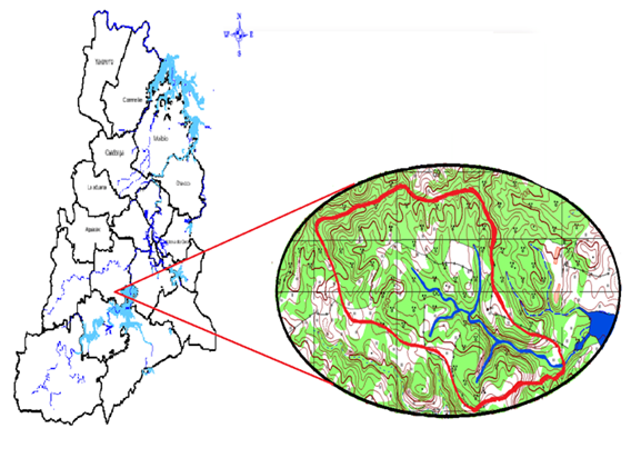
The location of the study area corresponds to the La Cuchilla and Dos Palmas cartographic sheets, at a scale of 1:25,000; between coordinates 580 583 latitude, and 167 169 longitudes; in the Caney del Sitio popular council, belonging to the Palma Soriano municipality (Figure 1).
Climate
To determine the climatic conditions of the micro-basin, the data from the equipment located at the station was analyzed. Gilbert hydrometric, where parameters such as: precipitation and temperature were evaluated.
Floors
The study of the soils of the microbasin was carried out by consulting the genetic classification of the soils of Cuba (Hernández, 2019), and the information provided by the soil map at a scale of 1:25,000, from the MINAGRI soil institute, in the mountain massif of the Sierra Maestra.
Vegetation
The classification of the existing vegetation was carried out through a field diagnosis, where linear transepts were made identifying the tree, shrub and herbaceous species that made up the natural formations. The results of the field inventory were corroborated with the vegetation maps for the study of the Classification of Vegetation in the Eastern Region of Cuba, prepared by Reyes et al (2011).
Hydrology
Using the cartographic map of the area, the main stream and its tributaries were identified, and with the Mapinfo software the total length of the streams was calculated to determine the drainage network that makes up the microbasin.
Analysis and proposal for change in land use
Based on the biophysical diagnosis carried out with field and office work, the following geomorphological variables of the study basin were studied: Gravelius coefficient, drainage density, concentration time; and with the use of a GIS, a map of the existing vegetation, current land use and socio-environmental aspects was prepared.
To determine the type of conflict, the methodology developed by Klingebield and Montgomery (1965, cited by Soplas Mas, et al., 2019) was used; the soil was classified based on its agro-productive capacity and the risk of losing it, to determine the type of conflict. The degree of slope of the plots, the properties of the soil and the current agricultural use were used as fundamental criteria.
Preparation of the current land use map
The current land use map was worked with satellite images of the area, which were transformed into TIF format with the MapInfo v.12 software, and extracted from the cartographic database of the GEOCUBA company. With this cartographic information, the different types of coverage were digitized.
Preparation of the Conflict map in land use
With the use of MapInfo v.12.0 software, a layer algorithm was carried out and the plots in conflict of use were obtained, through an overlap of the relief layers, and that of current land use; taking into account as fundamental criteria the type of use, the slope, the effective depth and the location with respect to the water network. With these elements, the areas located on the slopes of the channels, or at the head of the catchment basins, which made up the drainage network, were selected, obtaining the map of areas in conflict of use.
RESULTS AND DISCUSSION
Characterization of land use in the study area
Historically, the lands of the micro-basin have been dedicated to the cultivation of coffee as a fundamental basis of the economy of the area, in addition, a large volume of areas is used for the cultivation of minor fruits and livestock, this last line has been practiced for many years. years by the farmers of the area, without taking into account soil conservation techniques. Currently, the fundamental production of the micro-basin is based on the aforementioned lines, with the exception of livestock, which is deteriorated.
The natural vegetation was almost eliminated, where the wooded masses were felled indiscriminately with the introduction of coffee cultivation, plus migratory agriculture; although autochthonous species such as Cordia gerascanthus L., Cedrela odorata L., Swietenia mahagoni (L) Jacq., Calycophyllum candidissimum (Vahl) DC., 1999. Gua z a tomentose Kunth, Trichilia havanensis Kunth, and others, of great economic value.
It can be said that agricultural crops are found in areas surrounding river channels, and generally on steep slopes, which causes considerable soil erosion and deterioration of the hydrological regime of the micro-basin.
The fundamental production in this micro-basin is focused on the cultivation and harvest of 2 varieties of coffee: Coffea arabiga and Coffee. canephora Pierre, however, the yields vary from year to year with considerable instability, not showing a pattern on any indicator that affects this yield. The most successful reasons are in the delivery of land to people without culture in the agro-technical management of this crop, and due to the low rainfall, that affects the physiology of the plantations.
Results of biophysical factors
Relieve
The relief of the micro-basin is hilly, with a maximum height of 342 meters above sea level ( masl ), and the lowest part is located at elevation 160 (masl), close to the normal water level of the Gota Blanca reservoir . These are characteristics of the micro-basin, where the relief is hilly, with a well-developed river network, with abundant rainfall, they condition the surface runoff to be with impetuous floods, which causes strong erosion on slopes.
Climate: Precipitation and temperature
The climatological factor has great influence on the hydrological and biological regime of a given region, therefore, its detailed study allows making correct decisions about the management to be applied in each crop area, seeking the best effect on yields and ecosystem conservation.
In the analysis of climatic factors, it is evident that the months of greatest precipitation coincide with the rainiest of the spring period (May-October), very determining for coffee plantings as it is the fundamental crop of this agricultural scenario, also for the planting short cycle crops. The greatest increase in temperature corresponds to the summer months, where insolation in the tropics is greater, which suggests that at this time of year, crop protection against solar incidence should be improved and protection strategies should be designed. agrotechnical management in accordance with the humidity demand of traditional crops.
Floors
Within the perimeter that delimits this microbasin, the soils are sialitized brown. In the database indexed to the soil map of this geographical scenario, it is proposed that the existing soils in this region suffer the loss of the a+b horizons of 50 to 55 cm; They are moderately productive due to erosion and slope, which are limiting factors; and they are light to moderately clayey soils, with a sialitic composition.
Vegetation
The vegetation within the micro-basin is made up of degraded natural forests that were former coffee plantations, with few timber species of economic value; The vegetation cover is variable, being composed of fruit trees, shrubs and grasses.
In the vegetation map that appears in the atlas of the province of Santiago de Cuba, it is stated that: Original vegetation in this area was evergreen broadleaf forests (submontane mesophilic 400-800 meters above sea level), the climax vegetation is mesophytic forests, and the potential vegetation is a submontane mesophilic (Reyes, 2022).
Hydrology
The micro-basin under study is located in the middle part of the Cauto River basin, it is a tributary of the Gota Blanca reservoir, classified as supplying the population of the city of Palma Soriano; Its waters are also used for irrigation of various crops. The drainage network is made up of a stream named El Quemado, with a length of 2.5 km, into which 3 tributaries or dry valleys pour their waters, which flow only in the rainy season, with a drainage order of 3 according to the Horton index (1945, cited by Bera et al; 2018).
Its drainage density is 0.82 km/km 2, with a concentration time of 2.21 hours, and a slope in the main channel of 7 %. These values in a microbasin are considered medium to high, so the erosive potential and the transport of sediments to the river channels are greater.
Analysis of morphometric parameters
According to the calculations corresponding to each morphometric parameter, the study area is classified as a microbasin, which has an area of 304.72 ha, equivalent to 3.05 km 2 . and a perimeter of approximately 8 km. This micro-basin has an average slope of 17 %, and according to the Gravelius Coefficient (Kc=1.28) it has an oval shape.
Areas that have this type of high slopes are prone to soil instability, this phenomenon is more evident near the water network where the slopes are even steeper, consequently these soils generate a large amount and carryover of sediments (Rodríguez & Gordón , 2015).
Socio-economic characterization of the Santa Rita micro-basin
The Santa Rita micro-basin is located in the Caney Popular Council of the Site, occupying areas of the Santa Rita coffee-growing UBPC, and the 26 de Julio CCS. Bordering its demarcation perimeter is the town of Santa Rita de Tempú, at a distance of 12 km from the city of Palma Soriano.
According to the 2012 census, in this town there are 53 homes that were built for those affected by the dam in the early 1980s. The population that commonly lives in the place is estimated at 139 people, of which 75 are men and 64 women.
Distribution of land ownership in the Santa Rita micro-basin
Regarding land ownership, according to information from the rural cadastre issued by the GEOCUBA (2020) company; In the perimeter of the micro-basin there are 3 tenants: State, UBPC and private, of the latter with an increase due to the delivery of land in usufruct by the coffee UBPC (Table 1).
Table 1. - Distribution of land use by tenants and current uses
| Crops/Tenants | State | UBPC | Private | TOTAL |
| Forests | 7.21 | 59.64 | 48.59 | 115.32 |
| Coffee | 4.70 | 20.29 | 66.18 | 91.08 |
| Crops | 13.46 | 8.2 | 32.69 | 54.2 |
| Fruity | - | - | 3.5 | 3.5 |
| Idle | 6.03 | 17.64 | 7.15 | 30.8 |
| Grass | 8.54 | - | - | 8.92 |
| Hostel | - | 0.9 | - | 0.9 |
| TOTAL | 39.94 | 106.67 | 158.11 | 304.72 |
| % of total area | 13 | 35 | 52 | 100 |
As can be seen, the largest volume of area is occupied by the cooperative sector with 52 %, due to the delivery of lands in usufruct, mainly coffee-growing areas of the UBPC Santa Rita. The decision to transfer these lands was due to the limited workforce that the UBPC had, which led to a large volume of agricultural areas in its assets that were totally neglected, causing an increase in idle lands.
The fundamental economy of the micro-basin is based on the production of coffee, vegetables, fruit trees and small livestock. There is potential for beekeeping and forestry development, although without orderly exploitation.
In existing coffee plantations, the variety with which the highest production levels are achieved is the Coffea robusta variety, where an average of 2.34 t/ha -1 /year is obtained. This result does not correspond to a good yield if compared to what was reported by Aceves Navarro et al (2018) who report values between 5.7 to 7.7 t ha -1 with this variety in environmental conditions similar to the study area. but these low yields are conditioned by the low rainfall that has occurred in the last 10 years in this micro-basin.
Procedures used for land use planning in the micro-basin
Determination of Soil Slope
The slope was classified according to 5 ranges; ranging from mild to medium strong; About 47 % of the study area has slopes greater than 15 %, which shows a rugged topography, with limitations for carrying out agricultural activities in some areas of the micro-basin (Table 2).
Map of land use in the micro-basin
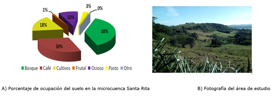
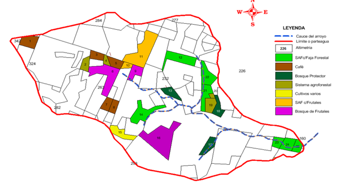
In the following Figure, it can be seen that the largest areas are occupied by secondary forests that were former coffee plantations, which were used for coffee cultivation for years, but the management applied to this crop, without taking into account conservation measures, soil caused the coffee plantations to degrade. These forests can be managed for timber harvesting in the medium and long term, if treatments such as improvement felling and low thinning are applied, which allow the development of species of interest for the forest economy (Figure 2).
Percentage of land occupation in the Santa Rita micro-basin B) Photograph of the study area
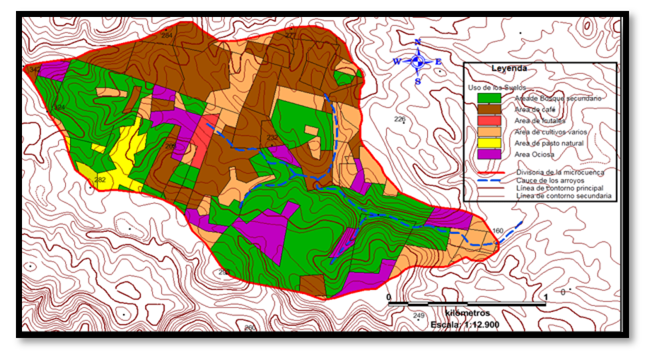
In the land use map, it can be seen that the crop areas located at the source of the catchment basins, and those located adjacent to the channels, constitute the areas in conflict of uses, because their current use causes erosion and sedimentation. to the water network of the micro-basin (Figure 3).
Conflict Analysis in land use
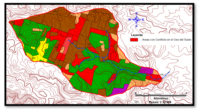
According to the analysis carried out, it was determined that 25 plots within the perimeter of the micro-basin, with an area of 52.91 ha, were located in areas with conflict in use (14 overexploited and 11 underused) (Figure 4).
In cases where the current use of the land is located on slopes with a slope greater than 12 %, and its use is the production of various crops, it was considered that these soils are being overexploited, considering that the agrotechnical work carried out for cultivation They cause erosion and sedimentation towards river channels.
In the plots with shallow soils and low fertility, but with dense cover vegetation, it was considered that they were underutilized, so they were proposed for exploitation in different uses such as agroforestry systems.
Land use conflict is understood as the discrepancy that exists between the current use and what an area should have (Jiménez, Barbier and Rivera, 2000). Its analysis is carried out by superimposing maps, which allows identifying both areas that, due to inappropriate use, present land degradation (overuse), and wasted areas (underuse) that have a greater potential than exhibited, information that could be used for management. optimal environment, develop territorial planning plans and promote sustainable environmental development (Guerra, 2014, cited by Roa et al., 2020) .
Proposal for land use planning in areas in conflict with current use
With the proposals for change in land use, the areas for coffee cultivation, temporary crops, protection forest and fruit trees increase, the latter being the one that achieves the greatest increase in areas by 5 % (Table 3). The proposed agroforestry systems will transform 25.45 hectares that were previously idle and/or poorly managed lands, achieving diversification of production and increasing the biodiversity of this ecosystem (Figure 4).
Table 3. - Relationship between the current land use, the prospective use and the total area to be reached by uses
| Ground uses | Current use(ha) | % Total | Using Perspect | Total(ha) | % Total |
| Forest | 115.32 | 38 | 4.57 | 120.01 | 39 |
| Coffee | 91.08 | 30 | 6.76 | 97.93 | 32 |
| Crop | 54.2 | 18 | 2.01 | 56.36 | 19 |
| Fruity | 3.5 | 1 | 14.12 | 17.62 | 6 |
| Idle | 30.8 | 10 | - | - | - |
| Pastures | 8.92 | 3 | - | - | - |
| Hostels | 0.9 | 0 | - | - | - |
| - | 25.45 | 25.45 | - | ||
| TOTAL | 304.72 | 100 | 52.91 | - | - |
For both the over-exploited plots and the under-utilized ones, it was proposed for prospective use to design agroforestry systems, where they will be integrated into the planting of annual crops, fruit species, forest species with honey-wood characteristics, which protect the soil from erosion, increase biodiversity and diversify fundamental productions, to generate employment, improve income and increase the economy of this ecosystem (Figure 5).
The proposed land use changes will increase the forest cover of the micro-basin, mainly in the water catchment basins, and on the slopes that make up the banks of the channels, where there are areas with a high degree of deforestation, due to being used for crops. temporary. The protection of river channels, and in fact the hydrological regime of the Santa Rita micro-basin, is substantially improved with the design of the forest strips.
Llerena Pinto (2019), suggests that the greater vegetation cover of a basin with forests, in direct relation to the vigor and state of conservation of these, will improve its infiltration capacity and the rainwater that reaches the soil will penetrate it., will gradually increase the flow and recharge the aquifers through subsurface and underground routes, producing a cleaner and more regular water flow, with smaller extreme annual flow ranges.
CONCLUSIONS
Within the perimeter of the Santa Rita micro-basin there are plots that are in conflict of uses, some with overexploitation of the soil, and others underused, with agro-productive potential.
The plots classified as conflict will be used for agroforestry, with coffee and fruit trees; and forests to protect water catchment basins.
The surface area of coffee, as a fundamental economic crop, increases, as well as the areas of fruit trees and food crops, which generate a source of employment and income for the residents of this agricultural scenario; improves the coverage of the protection strips of the channels, increases the forested area and the biodiversity of the Santa Rita micro-basin.
Annexes
Annex 1 (Table 4).
Table 4. - Database for the proposed change in land use according to type of conflict
| No Plot | Current usage | Usage perspective | Area(ha) | Conflict Type |
| 1 | Idle | Coffee | 2.03 | SubUt |
| 2 | Various crops | Agroforestry systems | 1.16 | AboutExp |
| 3 | Idle | Coffee | 1.15 | SubUt |
| 4 | Various crops | Agroforestry systems | 0.55 | AboutExp |
| 5 | degraded forest | Coffee | 1.39 | SubUt |
| 6 | Idle | fruit forest | 4.83 | SubUt |
| 7 | degraded forest | Coffee | 1.18 | SubUt |
| 8 | degraded forest | Coffee | 1.01 | SubUt |
| 9 | Various crops | fruit forest | 1.59 | AboutExp |
| 10 | Various crops | Agroforestry system with fruit trees | 0.63 | AboutExp |
| eleven | Various crops | Agroforestry system with fruit trees | 6.26 | AboutExp |
| 12 | Various crops | Agroforestry system with forest strips | 3.2 | AboutExp |
| 13 | Idle | Protective forest with evergreen species | 1.43 | SubUt |
| 14 | Various crops | Agroforestry system with forest strips | 3.38 | AboutExp |
| fifteen | Idle | Various crops | 2.01 | SubUt |
| 16 | Idle | fruit forest | 7.7 | SubUt |
| 17 | Idle | Protective forest with evergreen species | 1.65 | SubUt |
| 18 | Idle | Protective forest with evergreen species | 1.49 | SubUt |
| 19 | Various crops | Agroforestry systems | 1.57 | AboutExp |
| twenty | Various crops | Agroforestry systems | 0.25 | AboutExp |
| twenty-one | Various crops | Agroforestry system with forest strips | 2.13 | AboutExp |
| 22 | Various crops | Agroforestry system with forest strips | 2.49 | AboutExp |
| 23 | Various crops | Agroforestry system with forest strips | 1.09 | AboutExp |
| 24 | Various crops | Agroforestry system with forest strips | 1.67 | AboutExp |
| 25 | Various crops | Agroforestry system with forest strips | 1.07 | AboutExp |
REFERENCIAS BIBLIOGRÁFICAS
ACEVES NAVARRO, L.A., RIVERA HERNÁNDEZ, B., LÓPEZ CASTAÑEDA, A., PALMA LÓPEZ, D.J., GONZÁLEZ MANCILLAS, R., JUÁREZ LÓPEZ, J.F., ACEVES NAVARRO, L.A., RIVERA HERNÁNDEZ, B., LÓPEZ CASTAÑEDA, A., PALMA LÓPEZ, D.J., GONZÁLEZ MANCILLAS, R., y JUÁREZ LÓPEZ, J.F., 2018. Áreas potenciales y vulnerabilidad del cultivo de café tipo robusta (Coffea canephora P.) al cambio climático en el estado de Tabasco, México. Nova scientia [en línea], vol. 10, no. 20, [consulta: 12/04/2024]. ISSN 2007-0705. DOI 10.21640/ns.v10i20.1379. Disponible en: Disponible en: http://www.scielo.org.mx/scielo.php?script=sci_abstract&pid=S2007 -07052018000100369&lng=es&nrm=iso&tlng=es . [ Links ]
BERA, A., MUKHOPADHYAY, B.P., y DAS, D., 2018. Analysis of Adula River Basin in Maharashtra, India using GIS and Remote Sensing techniques. Geo-spatial Data in Natural Resources, DOI http://dx.doi.org/10.21523/gcb5.1702. [ Links ]
GEOCUBA, 2020. Mapa digital a escala 1:25 000 del catastro rural de Palma Soriano. 2020. S.l.: GEOCUBA. [ Links ]
HERNÁNDEZ-JIMÉNEZ, A., PÉREZ-JIMÉNEZ, J.M., BOSCH-INFANTE, D., y CASTRO SPECK, N., 2019. La clasificación de suelos de Cuba: énfasis en la versión de 2015. Cultivos Tropicales [en línea], vol. 40, no. 1, [consulta: 12/04/2024]. ISSN 1819-4087. Disponible en: Disponible en: https://ediciones.inca.edu.cu/index.php/ediciones/article/view/1504 . [ Links ]
LÓPEZ, M.Z.F., VENZOR, J.A.P., y AMAO, S.M., 2020. Diagnóstico hidrológico y ordenación de la Cuenca San Juan en Baja California Sur, México. Agronomía & Ambiente [en línea], vol. 39, no. 2, [consulta: 12/04/2024]. ISSN 2344-9039. Disponible en: Disponible en: http://agronomiayambiente.agro.uba.ar/index.php/AyA/article/view/95 . [ Links ]
REYES, O.J., 2011. Clasificación de la vegetación de la Región Oriental de Cuba. Revista del Jardín Botánico Nacional [en línea], vol. 32/33, [consulta: 12/02/ 2024]. ISSN 0253-5696. Disponible en: Disponible en: https://www.jstor.org/stable/23725915 . [ Links ]
REYES, O.J., CANTILLO, F.A., y GARRIDO3, P.B., 2022. Maturity mountain rainforest syntaxa from Sierra Maestra, Eastern Cuba. Revista Politécnica [en línea], vol. 18, no. 36, [consulta: 12/04/2024]. ISSN 1900-2351, 2256-5353. Disponible en: Disponible en: https://www.redalyc.org/articulo.oa?id=607872732004 . [ Links ]
ROA, C.C., DÁVILA, A.G.C., MÁRQUEZ, J.A.L., y CABEZAS, Y.O. de, 2020. Identificación de conflictos de uso de la tierra y propuesta de uso conservacionista en la subcuenca quebrada Mejías, municipio Antonio Pinto Salinas, estado Mérida, Venezuela. Revista de Topografía AZIMUT [en línea], vol. 11, no. 1, [consulta: 12/04/2024]. ISSN 2346-1055. Disponible en: Disponible en: https://revistas.udistrital.edu.co/index.php/azimut/article/view/15979 . [ Links ]
RODRÍGUEZ PECES, M.J., y GORDÓN PÉREZ, D., 2015. Análisis automático de la susceptibilidad de las inestabilidades de laderas provocadas por terremotos en un sector de la cordillera de los Andes, Ecuador. Revista de la Sociedad Geológica de España [en línea], vol. 28, no. 1, [consulta: 12/04/2024]. ISSN 0214-2708. Disponible en: Disponible en: https://dialnet.unirioja.es/servlet/articulo?codigo=6304565 . [ Links ]
Received: June 03, 2023; Accepted: March 04, 2024

