


 (pdf)
(pdf)


 SciELO
  SciELO
 Permalink
Cultivos Tropicales
ISSN 1819-4087
30--2021
Original article
Progress of the karstic-erosive processes of soils in San José de las Lajas polje
1Centro Investigaciones Marinas. Universidad de La Habana, Calle 16 no. 114 e/1ra y 3ra, Miramar. Playa, La Habana, Cuba, CP 10 300
2Departamento de Suelos, Universidad Federal Rural de Rio de Janeiro, Seropédica-Río de Janeiro, Brasil, CEP: 23.897-000
3Facultad de Contabilidad y Finanzas. Universidad de La Habana, Zapata y G, Vedado, Plaza de la Revolución, La Habana, Cuba, CP 10 400
An update of the karstic morphogenesis in San José de las Lajas polje is carried out, with the objective of making a quantitative evaluation of the of karstic-erosive process advance. It is from a baseline of more than three decades in reference localities, in accordance with the conditions of use and management to which soils have been subjected. It demonstrates the effects of intensive anthropogenesis on the Red Ferrallitic soils, as a result of a multifactorial process, conditioned not only by the intrinsic properties of the soil cover and conditions of use, but also dependent on the geological-geomorphological conditions. The application of the Integrating System of Qualitative and Quantitative Methods allowed characterizing the complex influence of the relief in the evolution of the main morphometric parameters of the dolines with losses between 12.33-15.95 t ha-1 year-1. It converted into length units show reductions in the A+B horizons between 0.98-1.20 mm year-1, which exceed the permissible threshold values in terms of erosion proposed by the USLE and the rates of formation of soils derived from limestone rocks in Cuba. It has a marked tendency to increase, which confirm the need for protection and improvement so that their “immunity” to erosion ceases to be a myth and becomes a priority issue for Food Security in the post Covid-19 development programs in Cuba. These soils represent the maximum potential to satisfy the country's current demand for agricultural and livestock productions.
Key words: evolution; relief; erosion
INTRODUCTION
Numerous are the studies developed in Cuba in the ferrallitic regions, but few have included the influence of karst morphogenesis. The long-standing information provides practical results and significant contributions to the knowledge of ecological, economic and social processes, in which their interactions justify the research carried out in the last 30 years 1, in the Southern Karst Plain Havana-Matanzas. It proves the effects of anthropogenesis, due to the water availability and the presence of Red Ferrallitic soils that form one of the most typical landscapes and of greater resource potential of the country 2.
Explorations of the karstic relief allow a broad understanding of both the physiography and the dynamics of current landscapes. In addition to providing traces of paleogeography and spatial differentiation of soil cover, determining factors in soil erosion 3-5, because if climate is the cause that generates erosive processes, relief is par excellence in the geographic area the factor that differentiates them. It is known that neighboring areas under the same climatic regime can experience erosive processes of very different magnitudes, conditioned by the geological-geomorphological peculiarities that characterize them 6,7.
Pioneering studies carried out in the Southern Havana Plain have shown that the relief and permeability of the supporting material 8-10 mainly influence the variability of the iron-rich cover. If these two factors are evaluated on a larger scale, it is found that the development of karstic forms (dolines, uvales, karstic depressions, valleys, etc.) and their consequences on the microclimate can have a significant impact on the microclimate). Their consequences on the micro-relief, promote favorable conditions for the differentiated manifestation of the hydric regime of soils 9, where dolines are considered diagnostic forms of karst 11 and even as the fundamental forms in this geomorphological context 12.
Considering these aspects, other authors specify the need to differentiate, at least, three main magnitudes of relief (macro, meso- and micro-relief) 13, to which should be referred the set of processes that simultaneously participate in the formation or degradation of soils. It is imperative that at different scales not only the main or predominant profile in the separate contour be taken into account 14, but also variations or changes at the meso- and micro-relief levels (Figure 1), thus contributing to a better understanding of the two- and three-dimensional organization of the agro-pedological cover.
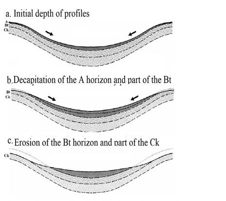
Figure 1 Conceptual model of the interaction of erosional processes in the slopes of a doline. Modified
The present research was carried out in San José de las Lajas polje and its objective was to perform a quantitative evaluation of the advance of the karstic-erosive processes, based on a baseline of more than three decades in reference localities, in accordance with the conditions of use and management to which the soils have been subjected.
MATERIALS AND METHODS
Description of the investigated areas
It was developed in the central portion of the Southern Karstic Plain Havana-Matanzas (Figure 2), in San José de las Lajas polje with an approximate extension of 469.80 km2 (1. The karstic-erosive dynamics show different degrees of development, in accordance with the conditions of use and management to which this region has been subjected, from investigations initiated during the year 1986, which constitutes the baseline of the information.
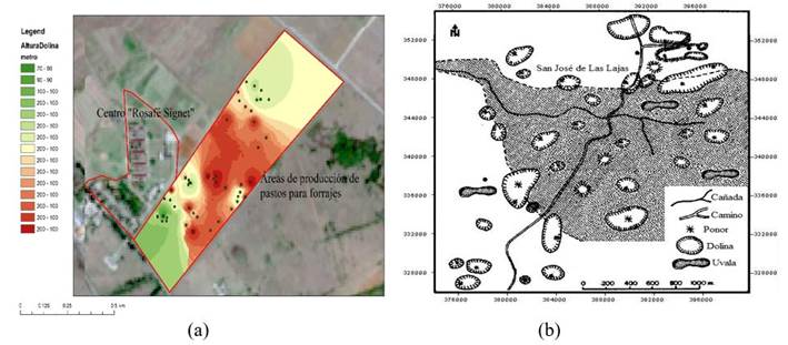
Figure 2 Digital elevation model in the Center I.A. “Rosafé Signet” (a). Main karstic forms of San José de las Lajas polje, Mayabeque province (b)
This agro ecosystem has been classified as one of the most humid of Cuban plains, receiving around 76-80 % of precipitations that occur in Mayabeque and Artemisa provinces 15, where the index of concentration of precipitations oscillates between 13-14 % 16 and the annual rainfall shows values between 1 400-1 600 mm 17.
The most widespread soils are predominantly of the Red Ferrallitic Leached Type, which can be correlated with the Rhodic Eutric Nitisol 18,19 and the Oxisol Order of the Soil Taxonomy 20, where the differences are given by the type of land use and the distribution of horizons. The textural composition generally has clay contents higher than 60 % with argillic B-horizon, well drained and with pH between 6.0 and 7.0.
Data used
The methodology was based on the application of the Integrating System of Qualitative and Quantitative Methods 21. It characterizes the karstic regions, conditioned by the availability and quality of their main attributes, characterizing 12 main profiles at depths of 0-20 cm, as at the level of the erosive diagnostic horizons A+B0-50 cm, in correspondence with the geological-geomorphological variations and agricultural use 22.
The C1 profile (No apparent erosion)9, located in an area in biostasis, with an initial depth of the A0-490 mm horizon, was taken as a reference to evaluate the loss magnitude of the Red Ferrallitic soils in different periods.
The morphometric analysis of the karstic absorption forms (dolines) was carried out at a scale of 1:10,000 and constituted the fundamental diagnostic index to evaluate the manifestations and intensity of karstification (Table 1), corroborated in the exploratory surveys, according to the proposal made in previous research 23,24.
Table 1 Formulas used for the calculation of morphometric parameters in San José de las Lajas polje, Mayabeque province
| Circularity Index (1) | Flattening index (2) | Diameter Ratio (3) |
|---|---|---|
|
|
|
|
| Where: Dm = larger diameter dm = smaller diameter | DM= average diameter | h = height difference (surface - bottom) |
Soil losses through karst depressions were obtained from those calculated in other investigations 25,26, by applying the empirical-conceptual erosion model MMF 27,28 in these localities, considering climatic variability, such as physical, physical-chemical and chemical properties. The weight units (t ha-1 yr-1) corresponding to the period 1986-2019 were converted into length units (mm yr-1) according to the proposal made 29 and the interpretation of the loss tolerance limits, according to the USLE model 30, adapted by other authors 31.
The geophysical works were carried out through 15 profiles traced in NW-SE direction and distances between them of 100 m; using the methods of electrical, symmetrical and vertical profiling, both with the Schlumberger symmetrical device. For the profiling measurements, the installation was taken with the following parameters: AB= 80 and MN= 10 m, with measurement steps in the profiles of 10 m, equal to the MN distance. The SEV points were performed through the profiles with distances between points of 100 m 32.
RESULTS AND DISCUSSION
Complex influence of relief on soil losses due to “soutirage” cavities in the San José de las Lajas polje
When attempting to describe the situation of the Red Ferrallitic soils in the investigated territories in a spatio-temporal context, any analysis goes through the phases of karst morphogenesis in which they are found, with respect to their physical, chemical and biological attributes that may favor, limit or inhibit their resilience 1.
The most characteristic depressions in San José de las Lajas polje are the funnel-shaped dolines (Figure 3), also called “subsidence” or “soutirage”. They are formed by successive land subsidence over a substrate with a large number of karst conduits. Usually, they are easily recognizable in the field where rainwater and surface irrigation water, almost always carrying a certain content of carbon dioxide in solution. When they run off through the different elements of the relief, they do so in a channeled way towards the bottom of the depression that function as local base levels or temporary sinks, with well-defined micro-basins, exerting a “turbillonar” suction effect in its interior, a description that coincides with those reported in similar regions 33,34. Sometimes the bottom is plugged by red clayey sediments (Figure 3), with no apparent structure and thicknesses that can exceed 5 m, enriched in organic matter and plant remains, a process that was verified by excavations carried out in several depressions in the central portion of the polje.
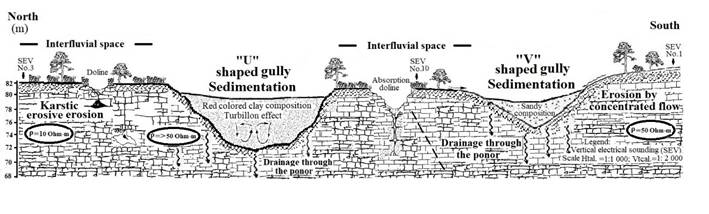
Figure 3 Karstic gully with “U” and “V” shaped valleys in interfluvial spaces in San José de las Lajas polje, Mayabeque province
Equally evident is the presence of karst gullies with “U” and “V” shaped valleys that, as geomorphological barriers, are arranged transversally to the general slope of the slopes (Figure 3), intercepting runoff and the products of erosion (soils and rocks), which are redistributed throughout the region in this way.
This “regulating” effect on erosion is often one of the basic elements of the hydrographic film, where the absorption forms and their component elements exert a certain control over surface and subsurface runoff. This generates different associations or miniaturization phenomena in the territorial complex itself at the micro-relief level, with a considerable reduction of the land base suitable for agricultural activity, which coincides with the descriptions made 35.
These processes are also taking place in the interior of the massif, as corroborated by the Vertical Electrical Soundings (SEV) (Figure 4). At levels where the resistivity values are between 10-20 Ohm-m, the thickness of the soils and karst is weakly manifested. Surfaces with resistivities of 50 Ohm-m and higher, the depth of the soils are lower and the karstic-erosive processes are more energetic, manifesting itself morphologically with the surfaces of greater density of dolines made up of very altered, decomposed and diaclased limestones filled with clayey sediments of very low resistivity (10 Ohm-m). It allow us to consider that the karstic-erosive processes had their origin in climatic conditions different from the present ones; that is to say, in conditions of higher humidity than the one that now prevails in the area 36.
On the other hand, in other polje sectors, these actions are not so evident and they are limited to the convex flexures of the relief (Figure 4), which surreptitiously enhance the detachment and areal removal of the finer fractions of the soils, at a rate directly related to diffuse runoff 37,38. In some cases directly joins the drainage network, while in others is incorporated into the ephemeral karstic gullies of “organized heterogeneity”, where it can reside for a long time, depending on the case, hydrodynamics that clearly differentiates these regions from any other 39.
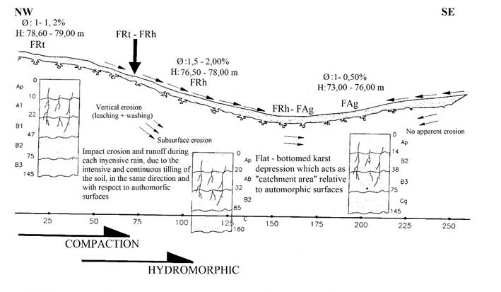
Figure 4 Dynamics of the karstic-erosive processes in a doline of San José de las Lajas polje, Mayabeque province
However, the cover of Ferrallitic soils can model by accumulation these depressions; masking, in a certain way, the related mechanism of action, which has caused largely the undervaluation of this complex process 13.
Sequential evolution of doline morphometric parameters and soil losses in San José de las Lajas polje
The increase in the morphometric dimensions of the dolines during the years 1986-2019 (Figure 5 and Table 2), allow us to confirm that a process or erosive modality inherent to the Red Ferrallitic soils is developing, called subsurface erosion. It is as a result of their removal towards the karst cavities, whose most evident manifestation is the amplitude of its mean diameter (MD) at the reduction expense of the interfluvial spaces or “dolinization”, with a marked tendency towards endorheism with an irreversibility of karstification in its unidirectional evolution 1,40.
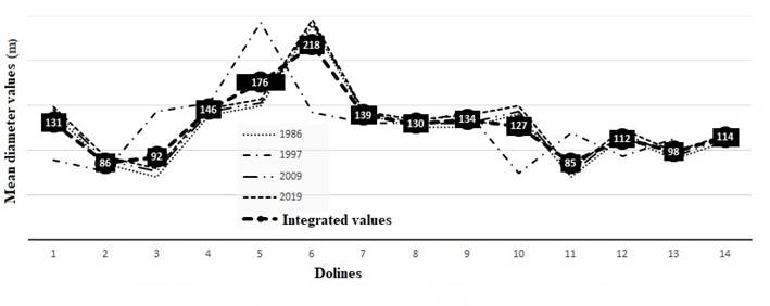
Figure 5 Evolution of the average diameter of the dolines in the Center I.A. “Rosafé Signet”, San José de las Lajas Polje, Mayabeque province, period 1986-2019
In fact, the flattening index (FI) shows values that morphologically are expressed in dolines with little dissection, as a result of a vertical dismemberment process in advance. Thus, doline No. 3 maintains a sustained flattening trend (5.63-5.45), because of an imbalance between areal erosion and corrosion in favor of flattening, which enhances the detachment and migration of the finer fractions of the solum that accumulate at the bottom.
Table 2 Evolution of the morphometric parameters of the dolines in the Center I.A. “Rosafé Signet”, San José de las Lajas Polje, Mayabeque province, period 1986-2019
| Doline No. | CI | FI | Dr | |||||||||
|---|---|---|---|---|---|---|---|---|---|---|---|---|
| DATA COLLECTION PERIODS | ||||||||||||
| 1986 | 1997 | 2009 | 2019 | 1986 | 1997 | 2009 | 2019 | 1986 | 1997 | 2009 | 2019 | |
| 1 | 2.04 | 1.36 | 1.72 | 1.73 | 10.13 | 7.17 | 9.12 | 8.02 | 7.53 | 5.47 | 7.55 | 3.78 |
| 2 | 1.94 | 1.55 | 1.54 | 1.40 | 8.44 | 8.59 | 5.08 | 7.17 | 8.80 | 9.22 | 9.36 | 4.56 |
| 3 | 1.71 | 1.34 | 1.35 | 1.37 | 5.63 | 5.67 | 5.35 | 5.45 | 16.00 | 13.69 | 13.28 | 6.37 |
| 4 | 1.92 | 1.55 | 1.55 | 1.56 | 17.96 | 10.21 | 10.18 | 9.54 | 9.13 | 9.26 | 9.30 | 4.45 |
| 5 | 1.60 | 1.14 | 1.14 | 1.12 | 10.63 | 12.86 | 8.98 | 8.81 | 32.00 | 29.81 | 30.36 | 13.98 |
| 6 | 1.75 | 1.33 | 1.33 | 1.33 | 13.33 | 12.81 | 11.94 | 11.67 | 14.00 | 14.15 | 14.25 | 6.97 |
| 7 | 1.53 | 1.04 | 1.04 | 1.04 | 9.09 | 5.69 | 8.07 | 7.54 | 114.40 | 96.66 | 116.80 | 36.23 |
| 8 | 1.92 | 1.56 | 1.56 | 1.57 | 12.19 | 14.64 | 11.84 | 10.50 | 9.14 | 9.08 | 9.12 | 4.53 |
| 9 | 1.56 | 1.10 | 1.11 | 1.13 | 16.88 | 10.17 | 10.42 | 9.94 | 52.00 | 41.84 | 39.71 | 16.68 |
| 10 | 1.61 | 1.15 | 1.15 | 1.41 | 10.00 | 9.34 | 8.78 | 10.55 | 30.00 | 29.33 | 28.36 | 14.10 |
| 11 | 2.14 | 1.83 | 1.83 | 1.87 | 10.83 | 8.50 | 8.81 | 9.12 | 6.66 | 6.77 | 6.81 | 3.56 |
| 12 | 1.56 | 1.11 | 1.14 | 1.16 | 7.81 | 8.01 | 7.46 | 8.94 | 48.00 | 36.00 | 30.58 | 33.58 |
| 13 | 2.00 | 1.66 | 1.66 | 1.66 | 9.38 | 8.61 | 8.25 | 8.13 | 8.00 | 8.00 | 8.06 | 4.00 |
| 14 | 1.64 | 1.19 | 1.17 | 1.19 | 10.88 | 9.64 | 8.43 | 8.73 | 22.86 | 22.55 | 25.00 | 10.84 |
| 15 | ----- | ----- | 1.25 | 1.28 | ----- | ----- | 8.33 | 8.74 | ----- | ----- | 18.00 | 7.76 |
| 16 | ----- | ----- | 1.50 | 1.52 | ----- | ----- | 3.75 | 3.99 | ----- | ----- | 10.00 | 4.35 |
However, in recent years, these dynamics have begun to undergo changes as a result of climatic variability. It has increased hydromorphism and carbonation-dissolution processes 41, whose most revealing expression is the appearance of ponors of different dimensions at the bottom of practically all dolines and the emergence of two other forms of absorption (dolines 15 and 16), which were not reported in previous studies.
Regarding the circularity index (CI), there are no notable changes in the values (1.04-2.14), due to the assumption that the circularity of the depressions is conditioned to the characteristics of the cracking system and dissolution process of the massif with intercepting structural elements. In addition to being subject to dissolution processes to give rise to the depressions, coinciding with results obtained 42.
The diameter ratios (Rd) vary in a wide range (3.78-116.80), which allow asserting that the genesis of the dolines is developed under a non-surface lithostructural control, related to the influence of the aquifer 43. Besides by seismic movements that have occasionally affected the territory, which, despite their low magnitudes, have caused strong shocks 44, in addition to the contaminating wastes from several industries in the area, which increase the chemical aggressiveness of groundwater carrying polycyclic aromatic hydrocarbons and polychlorinated biphenyls 45,46.
This sequential evolution of the morphometric parameters of the karst depressions has led to sustained increases in the loss volumes of the Red Ferrallitic soils (Table 3). It exceed the tolerance threshold values of 12, 5 t ha-1 yr-1 (47) for soils derived from limestone rocks and which, converted into units of length 29, show reductions in the A+B horizons between 0.98-1.20 mm yr-1. It has generated considerable reductions in the soil bottom, which corroborates, in a quantitative way, what other authors exposed in their respective investigations 48,49.
Table 3 Volume of soil losses with the equivalence values of surface removal in dolines of the Center I.A. “Rosafé Signet”, Mayabeque province, period 1986-2019
| Doline No. | Base line 1986 | DATA COLLECTION PERIODS | ||||||
|---|---|---|---|---|---|---|---|---|
| 1997 | 2009 | 2019 | ||||||
| Volume (t ha-1 year-1) | Surface (mm year -1) | Volume (t ha-1 year -1) | Surface (mm year -1) | Volume (t ha-1 year -1) | Surface (mm year -1) | Volume (t ha-1 year -1) | Surface (mm year -1) | |
| 1 | 15.96 | 1.17 H | 17.82 | 1.31 H | 17.65 | 1.29 H | 18.05 | 1.31 H |
| 2 | 17.63 | 1.35 H | 16.92 | 1.24 H | 20.21 | 1.48 H | 20.11 | 1.44 T |
| 3 | 21.36 | 1.57 VH | 22.13 | 1.62 VH | 23.61 | 1.73 VH | 23.66 | 1.75 VH |
| 4 | 14.85 | 1.09 H | 14.24 | 1.04 VH | 14.26 | 1.04 H | 15.03 | 1.14 H |
| 5 | 10.01 | 0.73 T | 8.36 | 0.61 T | 11.91 | 0.87 H | 12.07 | 0.89 H |
| 6 | 9.39 | 0.69 T | 9.73 | 0.71 T | 10.43 | 0.76 T | 11.01 | 0.81 H |
| 7 | 10.68 | 0.78 H | 17.14 | 1.26 H | 12.04 | 0.88 H | 12.82 | 0.90 H |
| 8 | 12.02 | 0.88 H | 10.03 | 0.73 T | 12.38 | 0.91 H | 13.00 | 0.94 H |
| 9 | 9.01 | 0.66 T | 10.14 | 0.74 T | 10.67 | 0.78 H | 11.08 | 0.81 H |
| 10 | 10.73 | 0.78 H | 11.51 | 0.84 H | 12.31 | 0.90 H | 12.79 | 0.92 H |
| 11 | 16.07 | 1.18 H | 20.23 | 1.48 H | 19.42 | 1.42 H | 19.98 | 1.44 H |
| 12 | 13.04 | 0.95 H | 13.08 | 0.96 H | 14.32 | 1.05 H | 15.19 | 1.19 H |
| 13 | 16.65 | 1.22 H | 18.12 | 1.33 H | 18.82 | 1.38 H | 19.01 | 1.40 H |
| 14 | 10.27 | 0.75 T | 11.63 | 0.85 H | 13.04 | 0.95 H | 14.02 | 1.02 H |
| 15 | --- | ----- | --- | ----- | 14.07 | 1.03 H | 14.99 | 1.75 H |
| 16 | --- | ----- | --- | ----- | 15.10 | 2.72 VH | 16.00 | 1.23 H |
| Mean | 12.33 | 0.98 H | 13.292 | 1.05 H | 13.70 | 1.20 H | 15.55 | 1.18 H |
H: High, VH: Very high, T: Tolerable
However, it is noteworthy that in the early 1990s, during the Special Period or economic crisis in Cuba, when agricultural activities in the polje were gradually disabled, a natural regeneration began with “healing” species such as marabú (Dichrotechys glomerata), aroma (Acacia farmesiana) and palms (Roystonea regia). It acted as an induced fallow and favored a certain morphoedaphological resilience or stability in the karstic-erosive processes 50,51. It enhanced edaphic recovery with some independence of the energetic value of the relief, an aspect that is reflected in the slowing of the morphometric parameters of dolines (Table 2), as well as in the volumes of losses with their respective values of surface removal equivalence, especially during 1997 (Table 3).
It is remarkable the plurality of other superficial karst forms, such as limestone outcrops of very variable diameters, karsolites from a few centimeters to 0.50 m (even larger), limestone pavement covered with proluvial-deluvial deposits, uvalas (bays) (with functional ponors), among others. It plays an important role in the formation of the karst; among others. Also it plays an important role in the polje, given their capacity to collect, transform or drain surface and groundwater, conditioned by the spatio-temporal evolution of the edaphic cover, which modify the dynamics of the environment and interfere with these interdependencies, a result that coincides with similar research 52,53.
The undervaluation of the exposed processes could lead to transforming the territorial complex in the coming decades into a “rocky desert”, leaving unproductive areas that in the past were suitable for a wide range of agricultural, livestock and forestry uses, as some researchers have warned 54. In any case, similar studies in these environments are very scarce worldwide, not only because of the time needed to obtain reliable results, but also because in the case of karst ecosystems 55, they are subject to constant disturbances that make research work difficult.
CONCLUSIONS
The dynamic evaluation of the main morphometric indicators shows the advance and intensity of the karstic-erosive processes in the investigated territory, characterized by the amplitude of the karstic depressions and increases in their loss volumes, with values of 12.33-15, 95 t ha-1year-1 in more than 75 % of the dolines. It exceeds the permissible limits in terms of erosion for soils derived from limestone rocks, which converted into units of length, show reductions in the A+B horizons between 0.98-1.20 mm year-1, which originates relevant losses in the soil bottom.
It is necessary to recognize the existence of water erosion and karstic-erosive processes in the Red Ferrallitic soils so that their “immunity” ceases to be a myth and becomes a priority issue for Food Security in the post Covid-19 development programs in Cuba. These soils represent the maximum potential to meet the demands of agricultural production, where agricultural research can play a crucial role in the transformation of karst systems, making them more sustainable and resilient.
BIBLIOGRAFÍA
1. Febles González JM, Febles Díaz JM, Sobrinho NMBA, Tolón-Becerra A, Lastra-Bravo X, Botta GF. Resilience of Red Ferralitic soils in the karst regions of Mayabeque Province, Cuba. Land degradation & development [Internet]. 2019;30(1):109-16. Available from: https://onlinelibrary.wiley.com/doi/pdf/10.1002/ldr.31921. [ Links ]
2. Rodriguez JMM, Chaple MC, Rodríguez PA, Mestre DH, Miranda AV. Los mapas de Paisajes del Atlas Nacional de Cuba LX Aniversario [Internet]. 2020 [cited 15/08/2021]. Available from: http://revistas.geotech.cu/index.php/rcg/article/view/3222. [ Links ]
3. Bakalowicz M. Karst and karst groundwater resources in the Mediterranean. Environmental Earth Sciences [Internet]. 2015;74(1):5-14. Available from: https://link.springer.com/article/10.1007/s12665-015-4239-43. [ Links ]
4. Poesen J. Soil erosion in the Anthropocene: Research needs. Earth Surface Processes and Landforms [Internet]. 2018;43(1):64-84. Available from: https://onlinelibrary.wiley.com/doi/full/10.1002/esp.42504. [ Links ]
5. Instituto de Geografía Tropical. Mapa de Erosión Potencial. In: Atlas Nacional de Cuba XL Aniversario. [Internet]. 2020 [cited 18/08/2021]. Available from: http://revistasgeotech.com/index.php/rcg/article/view/318/1315. [ Links ]
6. Medina H, van Lier Q de J, García J, Ruiz ME. Regional-scale variability of soil properties in Western Cuba. Soil and Tillage Research [Internet]. 2017;166:84-99. Available from: https://www.sciencedirect.com/science/article/pii/S01671987163022156. [ Links ]
7. Febles-González JM, Martínez-Robaina AY, Amaral-Sobrinho NMB, Febles-Díaz JM, Zonta E. The geological environments in the accumulation of heavy metals in soils of Pinar del Río. Cultivos Tropicales [Internet]. 2020;41(2):e05. Available from: https://www.researchgate.net/profile/Jose-Febles-Diaz/publication/344344367_The_geological_environments_in_the_accumulation_of_heavy_metals_in_soils_of_Pinar_del_Rio/links/5f6a4ccf299bf1b53ee9baea/The-geological-environments-in-the-accumulation-of-heavy-metals-in-soils-of-Pinar-del-Rio.pdf7. [ Links ]
8. Camacho-Diaz E. Etude des sols des plaines karstiques de la région occidentale de Cuba: étude d'une zone ouverte sur la mer située entre San Nicolas de Bari et Guanajay et particulièrement des sols ferrallitiques rouges compacts. 1980; Available from: https://www.documentation.ird.fr/hor/fdi:020798. [ Links ]
9. Febles González JM, Martin Alonso NJ, Hernandez S. L'érosion et l'utilisation des sols dans la plaine karstique de Cuba: étude de plusieurs cas. Sol et eau: résumés des actes du séminaire. Suelo y agua: resumenes de las actas del seminario [Internet]. 1986;717-28. Available from: https://www.documentation.ird.fr/hor/fdi:245609. [ Links ]
10. Bosch Infante D. Les sols des plaines karstiques de la région occidentale de Cuba: étude d'une plaine quasi-fermée située dans la zone de Catalina de Guines et particulièrement des sols ferrallitiques jaunes. 1981; Available from: https://www.documentation.ird.fr/hor/fdi:0039210. [ Links ]
11. Zeng C, Wang S, Bai X, Li Y, Tian Y, Li Y, et al. Soil erosion evolution and spatial correlation analysis in a typical karst geomorphology using RUSLE with GIS. Solid Earth [Internet]. 2017;8(4):721-36. Available from: https://se.copernicus.org/articles/8/721/2017/11. [ Links ]
12. Haryono E, Adji TN. Geomorfologi dan hidrologi karst. 2017; Available from: https://www.researchgate.net/publication/290608050_GEOMORFOLOGI_DAN_HIDROLOGI_KARST12. [ Links ]
13. Febles González JM, Vega M. Degradación del suelo por procesos de erosión hídrica (Degradação do solo por processos de erosão hídrica). Impactos ambientais provenientes da produção agrícola: experiências argentinas e brasileiras [Internet]. 2016;119-65. Available from: http://www.ia.ufrrj.br/zonta/impactosambientais2016view.pdf13. [ Links ]
14. USDA. Soil science division staff. In: Soil survey manual [Internet]. 18th ed: USDA Handbook. 2017. Available from: https://journals.lww.com/soilsci/Abstract/2017/03000/Estimation_of_Saturated_Soil_Paste_Salinity_From.4.aspx14. [ Links ]
15. INSMET. Instituto de Meteorología de Cuba. Resumen Sinóptico Mensual. [Internet]. 2012 [cited 15/08/2021]. Available from: http://www.insmet.cu/asp/genesis.asp?TB0=PLANTILLAS&TB1=MES&TB2=/Mes/Diciembre2012.htm&TB3=201215. [ Links ]
16. Vega MB, Febles JM. La agresividad de la lluvia en áreas rurales de la provincia la habana como factor de presión en la sostenibilidad agroambiental. II Seminario Internacional de Cooperación y Desarrollo en Espacios Rurales Iberoamericanos. Sostenibilidad e indicadores. Almeria [Internet]. 2008;14-6. Available from: https://docplayer.es/112943386-La-agresividad-de-la-lluvia-en-areas-rurales-de-la-provincia-la-habana-como-factor-de-presion-en-la-sostenibilidad-agroambiental.html16. [ Links ]
17. Silva JLB. Evaluación de los recursos hídricos de Cuba. Revista Geográfica [Internet]. 2016;(157):73-83. Available from: https://revistasipgh.org/index.php/regeo/article/view/21217. [ Links ]
18. Resources WRB for S. A framework for international classification, correlation and communication. In: World soil resources reports [Internet]. FAO Rome; 2006. p. 145. Available from: https://research.wur.nl/en/publications/world-reference-base-for-soil-resources-2006-a-framework-for-inte18. [ Links ]
19. Hernández-Jiménez A, Pérez-Jiménez JM, Bosch-Infante D, Speck NC. La clasificación de suelos de Cuba: énfasis en la versión de 2015 [Internet]. EDICIONES INCA; 2015. Available from: http://ediciones.inca.edu.cu/files/libros/clasificacionsueloscuba_%202015.pdf19. [ Links ]
20. USDA. Soil Science Division Staff. Soil survey manual Ditzler C, Scheffe K, Monger HC, editors. Washington, D.C.: Government Printing Office. [Internet]. 2017 [cited 15/08/2021]. Available from: https://www.iec.cat/mapasols/DocuInteres/PDF/Llibre50.pdf20. [ Links ]
21. Febles JM, Vega MB, Febles G. Sistema integrador de métodos cualitativos y cuantitativos para evaluar la erosión de los suelos en las regiones cársicas de uso ganadero de Cuba. Revista Cubana de Ciencia Agrícola [Internet]. 2008;42(3):313-7. Available from: https://www.redalyc.org/pdf/1930/193015504016.pdf21. [ Links ]
22. Pavlopoulos K, Evelpidou N, Vassilopoulos A. Mapping geomorphological environments [Internet]. Springer Science & Business Media; 2009. Available from: https://books.google.es/books?hl=es&lr=&id=N5htL6WHBiYC&oi=fnd&pg=PR5&dq=Mapping+geomorphological+environments:+Springer+Science+%26+Business+Media%3B+2009.&ots=mCffu2a5BF&sig=lBzEM5s1R7xYlAwYYtjSs6KklJE#v=onepage&q=Mapping%20geomorphological%20environments%3A%20Springer%20Science%20%26%20Business%20Media%3B%202009.&f=false22. [ Links ]
23. Llopis Lladó N. Fundamentos de Hidrogeología Carstica. Introducción a la geoespeleología [Internet]. Pueblo y Educación; 1982. Available from: http://espeleologiabibliografia.blogspot.com/2010/01/hidrogeologia-karstica-llopis.html23. [ Links ]
24. Cherlinka. Morfometrychni parametry reljjefu jak bazys dlja predykatyvnogho modeljuvannja prostorovogho poshyrennja gruntovykh vidmin. In Aghrokhimija i gruntoznavstvo. In: Proceedings of the Global Symposium on Soil Erosion [Internet]. Food & Agriculture Org.; 2019. Available from: https://books.google.com.cu/books?id=17y4DwAAQBAJ&pg=PA255&lpg=PA255&dq=Morfometrychni+parametry+reljjefu+jak+bazys+dlja+predykatyvnogho+modeljuvannja+prostorovogho+poshyrennja+gruntovykh+vidmin.+In+Aghrokhimija+i+gruntoznavstvo.;+2017&source=bl&ots=TSaDd6Em3q&sig=ACfU3U1K50uouOUskoMx_A2-ZjaD9kOfTA&hl=es&sa=X&ved=2ahUKEwjOvbiljbTyAhXWRjABHaUhAToQ6AF6BAgCEAM#v=onepage&q=Morfometrychni%20parametry%20reljjefu%20jak%20bazys%20dlja%20predykatyvnogho%20modeljuvannja%20prostorovogho%20poshyrennja%20gruntovykh%20vidmin.%20In%20Aghrokhimija%20i%20gruntoznavstvo.%3B%202017&f=false24. [ Links ]
25. González JM, Vega-Carreño M. Evaluación de la erosión de los suelos en las regiones cársicas de La Habana mediante el nuevo método EVERC [Internet]. 2006. Available from: https://www.researchgate.net/publication/329074985_EVALUACION_DE_LA_EROSION_DE_LOS_SUELOS_EN_LAS_REGIONES_CARSICAS_DE_LA_HABANA_MEDIANTE_EL_NUEVO_METODO_EVERC25. [ Links ]
26. Febles JM, Tolón A, Vega MB. Edaphic indicators for assesment of soil erosion in karst regions, province of Havana, Cuba. Land degradation & development [Internet]. 2009;20(5):522-34. Available from: https://onlinelibrary.wiley.com/doi/pdf/10.1002/ldr.92926. [ Links ]
27. Morgan RPC, Morgan DDV, Finney HJ. A predictive model for the assessment of soil erosion risk. Journal of agricultural engineering research [Internet]. 1984;30:245-53. Available from: https://www.researchgate.net/profile/Ddv-Morgan/publication/236770602_A_predictive_model_for_assessment_of_erosion_risk/links/56d5d73908aee73df6c053ad/A-predictive-model-for-assessment-of-erosion-risk.pdf27. [ Links ]
28. Morgan RPC. A simple approach to soil loss prediction: a revised Morgan-Morgan-Finney model. Catena [Internet]. 2001;44(4):305-22. Available from: https://www.sciencedirect.com/science/article/abs/pii/S034181620000171528. [ Links ]
29. Geler T, Ligtenberg A, de By R. Modelo para el pronóstico de la dinámica de erosión de los suelos debido a los cambios en el uso de la tierra [Internet] [MSc. Thesis]. 2004. Available from: https://www.researchgate.net/publication/28070052_Modelo_para_el_pronostico_de_la_dinamica_de_erosion_de_los_suelos_debido_a_los_cambios_en_el_uso_de_la_tierra29. [ Links ]
30. Kimble JM, Knox EG, Holzhey CS. Soil Survey Laboratory Methods for Characterizing Physical and Chemical Properties and Mineralogy of Soils. Application of Agricultural Analysis in Environmental Studies [Internet]. 1993 [cited 18/08/2021]; doi:10.1520/STP23868S [ Links ]
31. McCormack DE, Young KK, Kimberlin LW. Current criteria for determining soil loss tolerance. Determinants of soil loss tolerance [Internet]. 1982;45:95-111. Available from: https://acsess.onlinelibrary.wiley.com/doi/abs/10.2134/asaspecpub45.c931. [ Links ]
32. Reynolds JM. An introduction to applied and environmental geophysics [Internet]. John Wiley & Sons; 2011. Available from: https://books.google.es/books?hl=es&lr=&id=kMnHYMgMzVQC&oi=fnd&pg=PR6&dq=Introduction+to+Applied+and+Environmental+Geophysics&ots=rWXFjCOfHD&sig=KLutiMjsLrtvQg7hD-nPWcB0eDU#v=onepage&q=Introduction%20to%20Applied%20and%20Environmental%20Geophysics&f=false32. [ Links ]
33. Apollonio C, Delle Rose M, Fidelibus C, Orlanducci L, Spasiano D. Water management problems in a karst flood-prone endorheic basin. Environmental earth sciences [Internet]. 2018;77(19):1-15. Available from: https://link.springer.com/article/10.1007/s12665-018-7866-833. [ Links ]
34. Yan Y, Dai Q, Jin L, Wang X. Geometric morphology and soil properties of shallow karst fissures in an area of karst rocky desertification in SW China. Catena [Internet]. 2019;174:48-58. Available from: https://www.sciencedirect.com/science/article/abs/pii/S034181621830477634. [ Links ]
35. Naipal V, Ciais P, Wang Y, Lauerwald R, Guenet B, Oost KV. Global soil organic carbon removal by water erosion under climate change and land use change during AD 1850-2005. Biogeosciences [Internet]. 2018;15(14):4459-80. Available from: https://bg.copernicus.org/articles/15/4459/2018/35. [ Links ]
36. González JF, Cabrera JS, Vega MB, Sobrinho NA, García AC, Díaz JF. Effects of climate change on soils of cattle regions from the southern karst plain Habana-Matanzas, Cuba. Cuban Journal of Agricultural Science. 2017;51(1). [ Links ]
37. Anache JA, Wendland EC, Oliveira PT, Flanagan DC, Nearing MA. Runoff and soil erosion plot-scale studies under natural rainfall: A meta-analysis of the Brazilian experience. Catena [Internet]. 2017;152:29-39. Available from: https://www.sciencedirect.com/science/article/abs/pii/S034181621730003637. [ Links ]
38. Merchán Elena D, Luquin Oroz EA, Hernández García I, Campo-Bescós M, Giménez Díaz R, Casalí Sarasíbar J, et al. Dissolved solids and suspended sediment dynamics from five small agricultural watersheds in Navarre, Spain: a 10-year study. Catena [Internet]. 2019;173:114-130. Available from: https://academica-e.unavarra.es/handle/2454/3130838. [ Links ]
39. DENG Y, Dong XIA, CAI C, DING S. Effects of land uses on soil physic-chemical properties and erodibility in collapsing-gully alluvial fan of Anxi County, China. Journal of integrative agriculture [Internet]. 2016;15(8):1863-73. Available from: https://www.sciencedirect.com/science/article/pii/S209531191561223039. [ Links ]
40. Karampaglidis T, Benito-Calvo A, Rodés A, Braucher R, Pérez-González A, Pares J, et al. Pliocene endorheic-exhoreic drainage transition of the Cenozoic Madrid Basin (Central Spain). Global and Planetary Change [Internet]. 2020;194:103295. Available from: https://www.sciencedirect.com/science/article/abs/pii/S092181812030186740. [ Links ]
41. Febles González JM. Agro-environmental management and protection of Cuban Soils. La Protección del Medio Ambiente". Manejo y Protección Ambiental [Internet]. 2016;1(1):29-42. Available from: https://www.researchgate.net/publication/327164133_AGRO_-_ENVIRONMENTAL_MANAGEMENT_AND_PROTECTION_OF_CUBAN_SOILS41. [ Links ]
42. Morais F, Soriano MA. Análisis morfométrico de dolinas y parámetros geofísicos aplicados al estudio de los flujos de agua subterránea en la Cuenca del Ebro, Zaragoza, España. Geociências (São Paulo) [Internet]. 2017;36(2):221-32. Available from: http://www.ppegeo.igc.usp.br/index.php/GEOSP/article/view/1160342. [ Links ]
43. Magaz, A.R, Díaz, J.L, Portela, A, Rodríguez, J. Present main problems about cuban geomorphology and its importance in national economy. Ciencias de la Tierra y del Espacio [Internet]. 1989; Available from: http://repositorio.geotech.cu/jspui/bitstream/1234/3384/1/Principales%20problemas%20actuales%20geomorfolog%C3%ADa%20de%20Cuba%20y%20su%20importancia%20en%20econom%C3%ADa%20nacional.pdf43. [ Links ]
44. Margiotta S, Negri S, Parise M, Quarta TAM. Karst geosites at risk of collapse: the sinkholes at Nociglia (Apulia, SE Italy). Environmental Earth Sciences [Internet]. 2016;75(1):1-10. Available from: https://link.springer.com/article/10.1007/s12665-015-4848-y44. [ Links ]
45. Sosa D, Peña B, Escobar A. Evaluación de los hidrocarburos aromáticos policíclicos en granjas pecuarias y su relación con la inocuidad en pasto y leche. Cuban Journal of agricultural Science [Internet]. 2018;52(3):283-95. Available from: https://scholar.google.es/scholar?45. [ Links ]
46. Sosa D, Hilber I, Faure R, Bartolomé N, Fonseca O, Keller A, et al. Polycyclic aromatic hydrocarbons and polychlorinated biphenyls in urban and semi-urban soils of Havana, Cuba. Journal of soils and sediments [Internet]. 2019;19(3):1328-41. Available from: https://link.springer.com/article/10.1007/s11368-018-2137-646. [ Links ]
47. Soil Survey Staff. Keys to Soil Taxonomy. Twelfth Edition. United States Department of Agriculture Natural Resources Conservation Service; 2014. [ Links ]
48. Kevei IB. Vulnerability and auto-restoration capacities of karst geoecosystems. Zeitschrift für Geomorphologie [Internet]. 2016;60(2):235-55. Available from: https://www.researchgate.net/profile/Barany-Ilona/publication/307855712_zgfbarany/links/57ced5ae08ae057987abffc6/zgfbarany.pdf48. [ Links ]
49. Herrera Sorzano A. Mayabeque: atlas agrícola de una provincia cubana [Internet]. 1st ed. Editorial UH; 2019 [cited 18/08/2021]. Available from: https://isbn.cloud/9789597251262/mayabeque-atlas-agricola-de-una-provincia-cubana/49. [ Links ]
50. Parise M, Mazzei M. Peculiarity and vulnerability of karst settings, analyzed through a review of available environmental indices. In: Geophysical Research Abstracts [Internet]. 2016. Available from: https://www.researchgate.net/profile/M-Parise/publication/292977133_On_the_implementation_of_environmental_indices_in_karst/links/5c5bd64d299bf1d14cb1a2e0/On-the-implementation-of-environmental-indices-in-karst.pdf50. [ Links ]
51. Crowther TW, Van den Hoogen J, Wan J, Mayes MA, Keiser AD, Mo L, et al. The global soil community and its influence on biogeochemistry. Science [Internet]. 2019;365(6455). Available from: https://www.osti.gov/servlets/purl/155965051. [ Links ]
52. Fragoso-Servón P, Bautista F, Frausto O, Pereira A. Caracterización de las depresiones kársticas (forma, tamaño y densidad) a escala 1: 50,000 y sus tipos de inundación en el Estado de Quintana Roo, México. Revista mexicana de ciencias geológicas [Internet]. 2014;31(1):127-37. Available from: http://www.scielo.org.mx/scielo.php?pid=S1026-87742014000100010&script=sci_abstract&tlng=pt52. [ Links ]
53. Manco D. DESARROLLO HISTÓRICO GEOESPELEOLÓGICO EN EL TERRITORIO COLOMBIANO. In: III Simposio de exploradores [Internet]. 2021 [cited 21/08/2021]. p. 615-30. Available from: https://eresearch.areandina.edu.co/discover/display/n7137853. [ Links ]
54. Maura Santiago AV, Febles González JM. Una aproximación a los costos ambientales en los suelos ferralíticos rojos para el logro de la sostenibilidad. Cofin Habana [Internet]. 2018;12(1):192-208. Available from: http://scielo.sld.cu/scielo.php?script=sci_arttext&pid=S2073-6061201800010001354. [ Links ]
55. de Alba Alonso S, Alcázar M, Cermeño F, Barbero F. Erosión y manejo de suelo. Importancia del laboreo ante los procesos erosivos náurales y antrópicos. Agricultura ecológica en secano, soluciones sostenibles en ambientes mediterráneos. Madrid (España): Universidad Complutense de Madrid [Internet]. 2011;13-38. Available from: https://digital.csic.es/bitstream/10261/60833/1/Capitulo13_38.pdf55. [ Links ]
Received: September 16, 2020; Accepted: June 12, 2021

