


 Servicios personalizados
 Inglés (pdf)
 Articulo en XML
 Referencias del artículo
 Enviar articulo por email
 Citado por SciELO
  Similares en
SciELO
Similares en
SciELO 
 Permalink
Introduction
Based on recent UN predictions, the world’s urban population will reach 6.3 billion in 2050 and most of this increase will be in developing countries. Early signs for this increase are already evident manifesting in fast growing large metropolitan areas in South America. Cities like Rio de Janeiro, Sao Paulo, Bogota and Lima have doubled or even tripled their population in the last couple decades. This increase in urban population is result from combination of factors like natural population ingrowth, migration, government policies, infrastructure development [1].
The goal of this study is to investigate the water resources and hydrodynamics in the Lima coastal aquifer system with respect to recently experienced high groundwater demand in an area of Lima, Peru. Historical records show that in 1992 the city of Lima used total of about 7.8×10⁸m3 utilizing two main sources of water: (i) surface water from the Rimac River (2.8-4.1×10⁸ m3) and (ii) groundwater (up to 3.0×10⁸m3) from the Lima aquifer system that is in turn mostly recharged from infiltration of Rimac and Chillon rivers. However, with the rapid growth of population in the city of Lima, population increased from 3.5 million in 1997 to about 9.7 million in 2012, an increase of 6.9×10⁷m3 per year demand was observed. This required taping into alternative water sources. The new demand was compensated by additional extraction of groundwater. In 1997, the total amount of mined groundwater reached the critical level of 3.9×10⁸m3. The same year, several projects were initiated to optimize groundwater exploration including an artificial recharge of the Rimac coastal aquifer with surface water [2].
Efficient management of water resources requires a good understanding of the water budget. To delineate the sources contributing to the discharge of two coastal springs (i.e. coastal aquifer water), the relative abundance of 2H and 18O in groundwater collected from multiple wells along the Rimac River and Chillon River Basins was determined. Aquifer water ages were assessed using 3H content in these groundwater samples. Thirty-year records of the discharge of Rimac River and the groundwater level in observation of well located at sea level were used to estimate the groundwater residence time in the local coastal aquifer. This study allows better understand the coastal groundwater dynamics and water resources of coastal Peru and specifically the area of Lima.
Materials and methods
Study area. Physiographic settings and regional climate conditions
Peru is located along the west coast of South America from 3° to 18° south latitude and it has three distinct geographical regions; from west to east, these are: Costa, Sierra and Selva. The coastline of Peru (i.e., Costa) is tectonically active area with frequent earthquakes and high topography. The subduction of the Pacific plate along the west South America coastline results in the uplift of the Andes, the longest continental mountain range in the world with average elevation of 4 000m. Specifically in Peru, the mountain range of the Andes reaches elevation up to 6 000 m within about 140 km from the Pacific coast. The cold Humboldt Current plays major role in the climate of the west coast of South America and the Peruvian coastline causing cooler temperatures and higher rates of precipitation compared to geographical areas of the same latitude and altitude in other parts of the world. At altitudes between 1 000 and 2 000 m a.s.l. the average annual precipitation is 21 mm with relatively low intensity rainy season from December to April; whereas the wet season is one month shorter (from December to March) for areas of higher elevation: for elevations between 2 000 m and 3 500 m is 450 mm, between 3 500 and 4 000 the annual precipitation is 250 mm. In mountain areas with elevation above 4 000 m the rainfall can reach as high as 750 mm annually. Specifically, the Rimac Hydrographic Basin (2237.2 km2) receives permanent precipitation and 895.2 km2 receives intermittent precipitations [3].
Hydrogeology and aquifer stratigraphy of the Lima aquifers system
The Lima coastal aquifer is shaped by unconsolidated alluvial and interspersed layers of gravel, sand, silt and mudstone that are deposited over a low permeability material, which is bounded by volcanic-sedimentary rocks and granites in the substrate. The total aquifer area is about 260 km2 with a maximal thickness estimated between 400 m to 500 m [4]. An investigation by the Peru Geological Survey indicates that the permeability of the Lima Coastal aquifer in the valley is 1×10⁻³ m/s and changes to 10-4 m/s in the alluvial cone. The storage coefficient is 5% in the valley and 0.2% in the coastal area [4]. The deepest part (~ 100 m layer) of the Lima coastal aquifer is mainly composed of gravels and coarse-grained sediments in sand and clay matrix interspersed with fine-grained layers. Much finer unconsolidated sediments composed by sands, silts and mud form the middle part the aquifer. The upper part of the aquifer is mostly unconsolidated alluvial deposits, specifically the areas between the Rimac and Chillon rivers [5, 6].
Rimac Hydrographic Basin: hydrogeological characteristics
The total span of the Rio Rimac Basin is about 204 km, with average width of 16 km and total surface area of 3 398 km2. To the northeast, the basin borders with the Mantaro Basin, to the southeast with Lurin Basin and with Chillon Basin to the northwest and has direct connection with the Pacific Ocean to the southwest.
The Rimac River has 23 tributaries with main tributary the Santa Eulalia Basin, which has an area of 1097.7 km2 which comprises >30% of the whole watershed [3]. Most of the tributaries are situated at very high altitude, between 4400 m and 5200 m [5, 7]. The lower part of the Rimac Basin is 17.5 km long with a gradient of 1.1% and altitude of 195 m a.s.l. [5]. The gradient of the river ~is 34.5 m/km (or ~3%), the basin’s elevation changes from 5 000 m a.s.l. to 145 km before discharging into the sea [7]. The river flows through diverse landscape, in the highlands it crosses through wetlands, glacial meltwaters and small lakes in the central Cordillera and continues through steep narrow valleys onto a clastic wedge of coarse alluvial sediments inmountain valleys before reaching the Pacific coast [7, 8].
Sampling strategy and methods
To estimate the transit time of groundwater through the Lima aquifer system from the point of recharge of the Rimac watershed in the highland to the point of discharge at the beach face, data referred to the variation of annual Rimac River flow and groundwater level of a water well 1 km from sea are used. For comparing with age of water the contents of 3H and 18O in these samples are measured (figure 1).
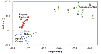
The Lima Delta is by the Rimac River to the north that flows from east to west, crosses Ate and Lima and discharges to the sea in front of Callao. The Rimac River replenishes the aquifer of the Lima Delta in the northern part of Lima. The alluvial deposits from the Rimac basin decrease from east to west and are dispersed to the north and south of the Rimac River. The deposits from the Chillon basin decrease roughly from the north to south (left). The geographical coordinates of a group of wells used by the Lima Waterworks Company (SEDAPAL) and high land water springs where water samples are analyzed. The diamonds correspond to wells located mostly in the basin of Rimac River; the squares correspond to wells in the basin of Chillon River and the triangles correspond to the high land water spring. The numbering of water springs is in order of altitude.
To study the origin and dynamics of Lima aquifer, we collect samples from 10 water spring in high part of the Rimac aquifer. The numbering is in order of altitudes. The 2H and 18O contents from these and the 25 above mentioned water samples are measured.
Results and discussion
Resident time of water in Lima aquifer
To understand better the groundwater-surface water interaction in the Lima aquifer system we used a long-term record of the discharge of the Rimac River and groundwater levels at well (identified as 71) in Miraflores, located ~1 km northeast from the Estrella coastal spring. A 30-year record (from 1980 to 2010) of the groundwater table shows overall decrease, the water level in the well in 1980 was -47 m and it dropped to -55 m in 2010 (Figure 2b). We attribute this general decreasing trend in the groundwater table to excessive groundwater pumping as response to an increased demand of the growing population the Lima metropolitan area during this period. Based on census the population the Lima metropolitan area had increased about 50%, from 5.7 million in 1993 to 8.5 million in 2012. However, the hydrographic record of the discharge of the Rimac River does not indicate change for the same period (Figure 2a). Nevertheless, the record shows two pronounced peaks, in 1986,the river flow reached 50 m3/s and it was 40 m3/s in 2001 (Figure 2a). Interestingly, similar pattern was observed in the well data, the groundwater level reached -49.5 m in 1989, dropped and peaked again in 2004 (close to -53 m).

Figure 2 (at left) Historic flow of Rimac River in Chosica. (1980-2010) Figure 2. (at right) static level well 71 Miraflores .
The figure 2 (at left) depicts the historic flow (m3/s) between 1980 and 2010 of the Rimac River in Chosica, 50 km east from the sea. Two maxima one in 1986 and other in 2001 can be observed. The figure 2 (at right) depicts the static level of well 71 Miraflores, which is 1 km from the beach, shows two maxima on the graph in 1989 and 2004. The well’s maxima in the static level of well 71 occurred three years after the two corresponding maxima in the flow of the Rimac River.
In each case, the maximum in the in the groundwater level of the coastal well is shifted three years from the observed peaks in discharge of the Rimac River. We hypothesize that this 3-year leg in time reflects the transit time of the groundwater within the Lima Coastal aquifer, from the areas of recharge in the highlands to the areas of discharge as coastal springs or as a submarine groundwater discharge (SGD). Similar pattern was also observed on a smaller scale. Annual variations of the Rimac River flow in the period from 2000-2006 are reflected by the annual groundwater static-level variations of well 71for the period 2003-2009.
Nevertheless the average age of water samples collected from the wells is 6 years. Taken into account the samples content water from several shells of soil, the difference is not a surprise. It is known that deeper waters are older than the upper ones.
Origin and dynamics of Lima aquifer
In general, the 2H content of the ten water samples taken in the upper part of the Rimac River aquifer shows approximately a decreasing trend with altitude (Figure 3 at left).
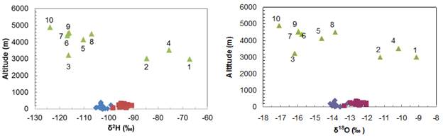
Figure 3 Relationship of 2H (at left) and 18O (at right) contents with the altitude of wells and water springs in the Rimac aquifer.
A similar behavior occurs with content of 18O (Figure 3 at right). However, the contents of 2H and 18O of samples 3, taken at the exit of a tunnel (Graton tunnel), located at 3100 m a.s.l., have contents of 2H and 18O corresponding to altitudes around 4500 m a.s.l., from where it is then assumed the water through geological faults that cross the tunnel. The contents of 2H and 18O of sample 2 correspond to higher altitudes to the place where it was collected; which is explained by the fact that it is close to the bed of the Rimac River, in a place where can reach water from the Graton tunnel.
The contents of Ca and SO4 of samples numbered 1 to 10 is approximately a decreasing linear function of altitude, which is consistent with the hypothesis that the water from higher water spring had traveled shorter distances. The high contents of Ca and SO4 of samples 2 and 3 (See figures 4 and 5), relative to the other 8, suggest that they correspond to waters that have traveled much longer distances than the other 8 samples, which confirms the evidences that are deduced from their corresponding contents of 2H. Moreover, the pH of 6.5 of sample 3 is much lower than the values of the other nine wells, which goes in the same direction as those evidences.

Figure 4 Relationship of Ca contents with of the altitude of wells and water springs in the Rimac aquifer.

Figure 5 Relationship of SO4 contents with of the altitude of wells and water springs in the Rimac aquifer.
The altitudes corresponding to the contents of 2H and 18O in the samples taken in the coastal region of the Rimac aquifer are between 3800 and 4200 m a.s.l., which is an indication that these are waters that the Rimac River receives from falling rains at different altitudes, with an average between those altitudes.
The fact that the Rimac River falls from 5000 m a.s.l. dragging material that is in its path is expressed in the high content of heavy metals from the samples from the Lima aquifer.
Conclusions
The Lima aquifer system is formed by several alluvial layers that fall in a direction from East to West in the Rimac Basin and North-East to South-West in the Chillon Basin.The Lima aquifer system is recharged by water from rains at higher altitudes of the Rimac and Chillon basins as well as by the Rimac and Chillon rivers on the upper part of the Lima aquifer.
Fluctuation of static level of water table of the Lima Delta (south of Lima) suggests that water recharged by the Rimac on the upper part of the Lima aquifer system (20 km from the sea) has a residence time of approximately 3 years until it reaches the sea.
The contents of 2H and 18O, Ca, SO4 of the Graton tunnel sample suggest that it corresponds to water coming from altitudes of 4500 m a.s.l.; and those corresponding to the wells of Lima, agree with the hypothesis that are reloaded by the river Rimac that brings rainwater that fell between 3000 and 5000 m a.s.l.

