


Mi SciELO
 Servicios personalizados
Servicios Personalizados
Articulo
 texto en
  Inglés (pdf)
 Articulo en XML
 Referencias del artículo
 Enviar articulo por email
Indicadores
-
 Citado por SciELO
Links relacionados
-
 Similares en
SciELO
Similares en
SciELO
Compartir

 Permalink
Revista Cubana de Ciencias Forestales
versión On-line ISSN 2310-3469
Rev cubana ciencias forestales vol.9 no.2 Pinar del Río mayo.-ago. 2021 Epub 07-Ago-2021
Original article
Exposure of infrastructure to forest fires and technical aspects for their protection. Case study in Central Chile
The exposure of human settlements to the impact of forest fires is a topic of special relevance for urban planning. We conducted a study in San José de Maipo (Chile) as an example that illustrates the level of vulnerability of houses and other buildings potentially exposed to fire emergencies. A census of houses in the study area was carried out to determine the spatial distribution of wildfire hazard. At the same time, an analysis was made of the construction standards and state of readiness of critical infrastructure. The results expressed in the mapping of the risk level indicate high values in the urban-forest interface and the urgent need to update municipal plans and ordinances, especially for the treatment of combustible plant material in areas of direct contact with houses and other buildings. This is an aspect that is repeated in practically all the municipalities of Chile and that needs to be reviewed to improve the forest fire protection plans.
Key words: Human settlements; Spatial distribution; Urbanization.
INTRODUCTION
The impact of forest fires is gaining more media relevance every day, especially due to the undeniable effects of climate change and the multiplicity of activities generated in territories with a high demand for goods and services. The growing real estate activity, the desire to have a second home away from the big cities, the permanent demand for water and the overexploitation of various natural resources associated with the forest, give rise to an overdemand for land use that exposes territories to a higher level of exposure and vulnerability to the occurrence of forest fires, among other types of events. There is international consensus that the world is changing, and that, in the particular case of fires, these are becoming increasingly aggressive, even though, in general terms, protection and combat mechanisms have experienced permanent improvements and learning from historically catastrophic events.
In the case of Chile, considerable progress has been made in terms of prevention, self-care and provision of means and resources to face the forest fire season. However, there are two major weaknesses that could potentially facilitate the aggravation of new fire episodes, especially in urban-forestal interface areas, that is, those areas where housing and other types of buildings are mixed with the forest or any type of potentially flammable vegetation in the immediate surroundings. These weaknesses are concentrated in the precarious updating of construction regulations, in the location of buildings, in the permits for the concession of habitable spaces and in general in the shortcomings of local territorial planning instruments that do not place with special force and obligatory nature the importance of preparing habitable environments in the face of the possibility of facing emergencies derived from the uncontrolled spread of fire.
For all of the above, this brief article illustrates and places in context the reality of forest fires in urban-forestal interface areas, taking for this purpose the Commune of San José de Maipo as a case study and research reference for the proposal of standards in critical infrastructure and self-care guidelines that can be replicated with their corresponding local changes, to other communes, municipalities or regions of the country. This background is based on the execution of field research and permanent contact with communities in the study area, together with the use of remote sensing tools and flights for the cadastre of houses in wooded areas. Moore (1981) and later Mikkola (2008) analyze the main characteristics that a house surrounded by combustible vegetation should have, providing valuable references in terms of defense distances and local characteristics in the construction of houses, but which in practice are only applied in those countries or territories where there is a standard of establishment according to the level of fire risk. It is common to find that most of the recommendations formulated in the literature are not applied, since they depend on the local regulations and norms that regulate the way and place to build.
There is a growing interest in Chile to carry out studies in contact zones between buildings and forests, where there is a permanent construction activity and with it, activity in the casuistic agent of occurrence and spread of forest fires. This interest is even greater if we consider the growing need to apply local mitigation strategies for the effects attributable to climate change, and also to the permanent demand for natural resources that in one way or another triggers the increase in the probability of catastrophic events, including forest fires. However, little is known about the technical standards and necessary safeguards to be taken in terms of design, self-protection and management of danger zones. On the contrary, a varied background of industrialization and prefabrication could be applied to the implementation of new real estate projects considering protection standards (Tapia 2016). Existing regulations regarding standards and location of habitable constructions are weak; contributions in this regard are found in May et al., (2017). Due to the above, there are regulatory aspects that are inconsistent and partially regulated, which, added to the scarcity of regulatory issues regarding materiality and criteria of harmony with the environment, install the need to study on this issue, and propose ways of development for the strengthening of protection systems and emergency care.
MATERIALS AND METHODS
As a first step, a territorial evaluation of the problem of forest fires in the Commune of San José de Maipo was carried out, for a total area of approximately 500 thousand hectares (Figure 1) and 23 localities inserted in different conditions of vulnerability to forest fires. For this purpose, a first multi-criteria spatial analysis was carried out, called `Determination of Protection Priorities', in order to identify, evaluate and locate the main areas with a high demand for protection, and thus support the characterization of critical areas that could contain built-up areas and complementary infrastructure.
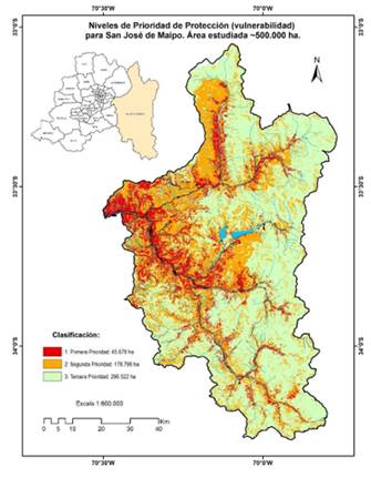
This analysis consisted of weighting three groups of territorial variables associated with fire risk (probability of occurrence based on a history of previous fires, their causes, the activities of the population and local infrastructure), hazard (potential fire behavior depending on the type and state of combustible vegetation), and territorial vulnerability (based on the potential damage that fire may cause in the event of future fires). All these variables and ranges (values) were constructed through successive rounds of consultations with local communities through participatory workshops, using methods of perception and transcription of information, for the assembly of the multi-criteria matrix (Table 1) that allowed the calculation of Protection Priorities, which translates into a colored map with three priority categories: low, medium and high, with a reclassification scale based on the spatial distribution of the data obtained.
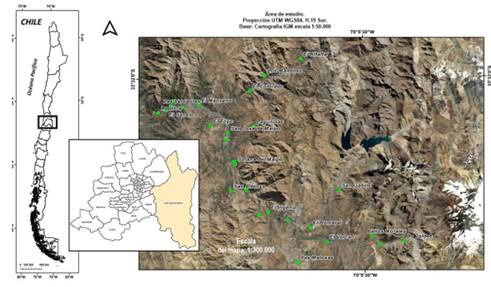
Table 1. - Variables used for the analysis of Determination of Protection Priorities
| General variables | Specific variables | Subvariables |
| Risk | Historical occurrence Potential ocurrence | Road network Isoleted houses Inhabited centers |
| Hazard | Characteristic of combustible vegetation Slope Accessibility | Potential for spread Resistance to control |
| Potential damage | Infraestructure Productive values Environmental Values | Isoleted houses Inhabited centers Taps, police units, others, farms and productive units, others Tourist and culture attractions Public and private wild areas |
At the same time, flight campaigns were conducted in the areas classified as urban-forest interface using drones (Phantom IV) in low altitude circuits, in order to form photographic mosaics that would allow a spectral separation process for the identification of dwellings. This result made it possible to characterize the precise content of the areas classified as first priority for protection. These two initial steps: the map and the cadastre of houses, made it possible to subsequently evaluate the exposure condition of various types of infrastructure, which were evaluated from the point of view of the construction standards currently in force in different legal bodies, including the General Ordinance of Urbanism and Construction (OGUC) and technical prescriptions, many of them of a local nature not necessarily normative or binding with other instruments, among them the building permit and delivery of works.
Three levels of geographic perception were established: the macro scale (1:600 000) that reviews the territorial aspects at the level of the entire commune (fuel continuity and level of protection priority), then the meso-scale (1:30 000) that deepens the effects of the project on the environment: 30 000) that delves into the effects of interface forest fires (proximity of groups of houses and infrastructure to wooded areas), and finally analyzes the regulatory situation of the houses installed in these areas and their structural and site characteristics (micro-scale, level 1:15 000 and smaller), emphasizing vulnerabilities (linked to the normative and regulatory).
The micro-scale level has been defined in the context of the wildfire assessment methodology defined by Castillo et al., (2013), who analyzed the Valparaiso port interface following these three levels of geographic perception. The micro-scale level has also been proposed based on the methodology of Garay et al., (2018) and considering both national and international regulations. For this study, a representative sample of 158 dwellings was established, considered in the areas over which the levels of vulnerability and exposure to fire were determined. The sample was selected in 9 of the 23 localities, considered the most relevant from the point of view of density and diversity of materiality conditions possible to identify and quantify. This sample is therefore considered representative for the entire Commune of San José de Maipo. In these residences, 8 construction typologies were established on which 37 indicators were defined that are directly linked to the level of fire defense. From these 5 typologies, a hierarchy of problems was built by means of a Pareto frequency diagram, considering in this selection the current normative instruments that allow covering the presented problem. In this way it was possible to establish 20 aspects or problems that need to be incorporated into existing regulations and also to consider the applicability of foreign standards (NFPA Standard of the United States), and technical references available at the Ministerio de Vivienda y Urbanismo 2009, Ministerio de Vivienda y Urbanismo 2014a, Ministerio de Vivienda y Urbanismo 2014b, Ministerio de Vivienda y Urbanismo 2016, Ministerio de Vivienda y Urbanismo 2017, adapted to solve the identified problem.
RESULTS AND DISCUSSION
The previous territorial evaluation based on the multi-criteria analysis showed that more than 45 thousand hectares present the highest values of exposure to fire, and that they compromise almost the entire area immediately surrounding the main localities of the commune.
The First Priority areas, i.e., those areas with the highest levels of exposure to the impact of forest fires, correspond to sectors associated with populated settlements and communication routes. The results derived from the GIS analysis are now complemented with the analysis of vulnerable zones previously studied by CONAF's Fire Management Unit in 2016 for this Commune, as a way of analyzing and validating the results of the Risk, Hazard and Potential Damage analyses described in Table 1.
Confronting the results of the cadastre of buildings in the interface areas overflown with drone and interpreted by satellite, the territory in question has 3 992 houses and isolated structures in wooded areas, of which 92 % of them are located in areas of First Priority of Protection. This indicates the high level of exposure to danger in which these structures are located, according to the multi-criteria analysis. At the general level, the total record for the commune indicates 6 926 dwellings according to official data from INE (2018), of which 5 132 are occupied with dwellers present, 432 with absent dwellers, 284 unoccupied due to sale, awaiting lease or abandoned, 1 002 correspond to seasonal private buildings and finally, 76 correspond to collective dwellings.
At the macro scale (1:600 000) and for the quadrant of data processed with the multicriteria analysis, there is a predominance of 46.4 % of the commune dominated by a high continuity of vegetation, with a predominance of dense native trees (species of the forest and sclerophyllous scrub of Central Chile in different degrees of coverage), of mixtures of plantations with exotic species and land located at the bottom of ravines with dense trees of different species and structures. This proportion is 84 % intercepted in areas of high forest fire danger, according to the analysis of the Determination of Protection Priorities (Figure 2). At this scale it is not possible to identify adequate road infrastructure connectivity. On the contrary, the main watersheds that supply services to the main population centers and show a greater danger condition associated with roads and watercourses stand out.
At the mesoscale (1:30 000), 28 groups of buildings were identified, of which 23 are associated with population centers at different densities of structures. Through satellite interpretation considering minimum distances established as criteria for the zoning of danger due to the heat emitted by fire in distance (radiation), it is evident that a group close to 50 % of the buildings are without any type of distance from the vegetation. In parallel, the occurrence of fires is evidenced, in this last example, in a large forest fire occurred in a sector called El Canelo, in December 2019, with an affected area of 419 hectares and whose perimeter was very close to isolated houses (Figure 3).
On this scale, it is observed in the field that the dominant vegetation intercepts 91 % of all localities, neighborhoods and isolated dwellings. There are natural areas that, due to their extension and conformation, do not have a greater possibility of spreading, including military zones and private properties that have a clearance area. However, the meso-scale perception details an almost absolute absence of a territorial framework that represents a level of organization and preparation for the possibilities of evacuation in the event of fire. This has been confirmed in the facts, by the serious fires that have occurred among the period 2017-2020 in various sectors qualified with high fire danger and the scarce connectivity by roads, which greatly hinders emergency attention.
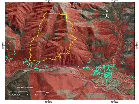 The highlighted points correspond to houses that do not comply with any minimum distance from the perimeter edge (direct contact with the vegetation). The areas highlighted in dark red correspond to the areas with the greatest vulnerability to fire.
Fig. 3. - Synoptic of the forest fire perimeter (Canelo Alto, in yellow border) in the upper part of the figure (419 hectares)
In the field, there is little concern for the management of the surrounding vegetation in terms of maintaining a defensible space. The accumulation of combustible vegetation in the surroundings sets of terraces, flammable roofs and wooden buildings, as well as the presence of hedges or bushes are key aspects in the ease of fire advance. At the meso-scale it is possible to quantify fire behavior parameters and define a range of recommended distances to delay the time of arrival of the fire from one burning end to the other without burning. This aspect is measured by means of mathematical expressions that make it possible to determine the amount of energy emitted mainly by radiation and to a lesser extent by convection, when the fires acquire greater size and perimeter of activity.
According to the expected radiant energy and the maximum threshold supported to have the possibility of combat, it was determined that the defensible space should consider aspects of distance to homes and power lines, easements and free circulation areas through which people and vehicles need to pass. On a regulatory level and at this scale, the content of the Communal Regulatory Plan and its relationship and influence on the scales of analysis were reviewed. The result of this review indicates that the commune does not have its own plan and is governed by the Intercommunal Regulatory Plan of Santiago elaborated in 1994. This condition and backwardness in this instrument is a factor highly incident in the problem and the associated vulnerabilities. Faced with this weakness, the municipality has created a municipal ordinance that includes aspects of fire mitigation measures but is not fully developed and established as a protocol for the 23 localities and communities that make up this commune. Among some of the measures contained in this ordinance is the responsibility of the electric companies to clear vegetation from the wiring, as well as the maintenance of the neighbors' own gardens, although there is not yet a significant level of supervision.
At the micro scale (1:15 000), the result of the survey of the 158 sampling points for the 9 localities resulted in a typification of the constructive typologies, considering the nomenclature coming from the Census Districts of Chile reported in INE (2018a and 2018b). This corresponds to a classification of 8 codes referring to the materiality and general characteristics of the structure (Table 2).
Table 2. - Description of construction typologies, based on the field survey
| Code | Description |
| A | House with reinforced concrete walls. Concrete slab roof. Clay, metal or cement roof tiles. Concrete floor, covered with ceramic tile or other material. With building permit and/or municipal reception |
| B | House of masonry walls (confined) in bricks made by hand or machine; concrete blocks or stone. Zinc or fiber cement roofing. Concrete floor, covered with ceramic tile or other material. With building permit and/or municipal reception. |
| C | House of stone masonry walls, not confined in a reinforced concrete structure. Zinc or fiber cement roofing. Concrete floor, covered with ceramic tile or other material. |
| D | With building permit and/or municipal reception. House of partition walls lined on both sides. Wood. Zinc or fiber cement roofing. Concrete floor, covered with ceramic tile or other material. With building permit and/or municipal reception. |
| House of partition walls lined on both sides. Steel. Zinc or fibers cement roofing. Concrete floor, covered with ceramic tile or other material. With building permit and/or municipal reception | |
| F | Partition walls without interior lining. Roofing of zinc or fiber cement sheets. Concrete floor, covered with ceramic tile or other material. Without building permit and/or municipal reception. |
| G | House of adobe, mud, quincha, pirca or other. Roof made of zinc or fiber cement sheets. Concrete or earth floor. Without building permit and/or municipal reception. |
| H | House of precarious materials (tin, cardboard, plastic, etc.). Without building permit. |
From this information (Table 2), the analysis of construction typologies was carried out. The evaluations carried out in the different localities of San José de Maipo showed that the houses present in the area correspond to classes B and D, where the first corresponds to houses with confined masonry walls and the second corresponds to houses with partition walls lined on both sides, structural material, wood. Thus, of a universe of 158 units evaluated, distributed in 9 localities of the commune (San José de Maipo, El Canelo, El Ingenio, El Manzano, Las Vertientes, El Melocotón, San Alfonso, San Gabriel and Los Maitenes) correspond to these two categories. The rest corresponds to houses with partition walls without interior lining, stone masonry, adobe, houses made of precarious materials, partition walls lined on both sides, steel and, finally, houses with reinforced concrete walls. From this first evaluation, classification codes were constructed for problem situations associated with classes B and D. 37 problem descriptors were identified (Table 3) which were hierarchized for the 9 localities (Figure 4), in order to identify the most frequent demands that could be considered for the current construction regulations, and the references that would allow supporting the improvement of the infrastructure as a whole.
Table 3. - Codes of problematic situations detected in the homes evaluated
| Code | Description of problem |
|---|---|
| ACDCE | Isolated construction with trees in direct contact with the electrical wiring. |
| ACVTE | Continuous facade with trees in contact with the dwelling and electrical wiring |
| BCC | Balconies or terraces have combustibles nearby |
| BI | Balconies or terraces are not covered by non-flammable material |
| BRF | Exterior cladding of low fire resistance |
| CACVL | Isolated construction in contact with woody vegetation |
| CBNC | Houses below street level |
| CC50 | Construction more than 50 % in contact with woody vegetation CCEC Construction in contact with debris |
| CCEC | Building in contact with combustible debris |
| CCVNV | Continuity of vegetative and/or non-vegetative fuel exists |
| CDC | House with a direct escape route to the roadway |
| CMCAE | Wooden building in contact with electrical supply |
| CMD | Deteriorated wooden house |
| CP20 | Construction on slope with more than 20 % inclination |
| CPCC | Protective fences in direct contact with combustible load |
| CPEBA | Construction with raised piles and open base |
| CPI | Protective fences are flammable CPV Construction with poor ventilation |
| CPV | Poorly ventilated construction |
| CRE | Construction surrounded by debris |
| CTE1 | Construction with power lines less than one meter from the street |
| CVEI | Construction with insufficient evacuation routes |
| DEM | Structural damage to walls |
| DV | The dwelling does not have ventilation ducts |
| IH | Housing with predominance of brass, cardboard or plastic. No building permit |
| LRM | Site located on the line of mass removal |
| MN | The house does not have thermal insulating materials acordinó to current regulations. |
| NPP | There is no evidence of pruning and if it is done, it is not adequate |
| SAA3 | Vertical spacing between shrubs and trees is less than 3 times the height of the shrub |
| SM05 | Very small site areas (confinement and immediate adjacency) |
| SV | Maximum percentage of glazed area exceeds what is allowed in the zone |
| TAA | Roofs with open eaves |
| TMCA | Timber roofing in contact with trees |
| TME | Roof complex in poor condition |
| TUB | Roof used as a warehouse |
| VEOD | Narrow, obstructed or difficult to pass through evacuation routes |
| VIB | Houses is inserted in the forest |
| VM | The windows are mostly made of monolithic glass |
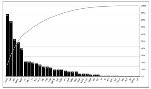
The diagram allows us to visualize the most frequent problem situations found in the commune, where 95 % of the problems are found within the 20 codes described in Table 4.
Table 4. - Problem situations, frequency and percentage of occurrence
| Indicators | José de Maipo | El Canelo | El Ingenio | El Manzano | Las Vertientes | El Melocotón | San Alfonso | San Gabriel | Los Maitenes | Outstanding Totals |
| SM05 | 62 | 3 | 18 | 16 | 9 | 7 | 10 | 10 | 5 | 140 |
| VM | 55 | 7 | 20 | 14 | 8 | 7 | 10 | 10 | 5 | 136 |
| NPP | 37 | 4 | 6 | 9 | 8 | 7 | 10 | 10 | 4 | 95 |
| CACVL | 34 | 4 | 15 | 8 | 7 | 7 | 9 | 9 | 4 | 97 |
| SAA3 | 28 | 3 | 5 | 7 | 8 | 7 | 8 | 8 | 4 | 78 |
| TMCS | 15 | 3 | 8 | 2 | 5 | 4 | 7 | 7 | 1 | 52 |
| DV | 15 | 1 | 2 | 7 | 3 | 3 | 7 | 7 | 2 | 47 |
| CPV | 14 | 3 | 4 | 7 | 7 | 7 | 7 | 6 | 5 | 61 |
| TAA | 13 | 1 | 4 | 6 | 5 | 7 | 6 | 6 | 4 | 52 |
| CPCC | 12 | 1 | 11 | 11 | 8 | 6 | 6 | 6 | 4 | 65 |
| BRF | 10 | 1 | 14 | 12 | 7 | 5 | 6 | 6 | 5 | 66 |
| CP20 | 10 | 0 | 0 | 0 | 2 | 2 | 6 | 6 | 3 | 29 |
| CC50 | 9 | 0 | 1 | 3 | 7 | 5 | 6 | 6 | 3 | 40 |
| VEOD | 7 | 3 | 0 | 1 | 1 | 4 | 5 | 5 | 2 | 28 |
| CMCAE | 7 | 1 | 2 | 3 | 2 | 1 | 6 | 6 | 2 | 30 |
| TME | 7 | 0 | 1 | 3 | 2 | 2 | 5 | 5 | 3 | 28 |
| CPI | 6 | 1 | 7 | 6 | 3 | 3 | 5 | 5 | 5 | 41 |
| CVEI | 5 | 2 | 0 | 2 | 1 | 4 | 3 | 5 | 2 | 22 |
| CMD | 5 | 1 | 1 | 2 | 1 | 0 | 2 | 2 | 1 | 15 |
| LRM | 5 | 0 | 0 | 0 | 2 | 0 | 3 | 3 | 4 | 17 |
Consequently, the problems mostly detected in the tour of the localities correspond to 140 houses with very little site area, promoting adjacency with other buildings (SM05), windows with monolithic glass (VM), building contact with woody vegetation (CACVL), absence of pruning (NPP), scarce vertical separation between trees and bushes (SAA3), fences in contact with combustible vegetation (CPCC), exterior siding with low fire resistance (BRF), poor construction ventilation (CPV), wood roofing in contact with tree branches (TMCA), open eaves exposed to vegetation (TAA) and absence of ventilation ducts (DV), among the problems mostly found in the 9 locations. This tree of problems found for the evaluation of construction typologies made it possible to establish a proposal of references for the proposed solution, based on the ideal normative instrument to favor this solution (Table 5).
Table 5. - Matrix of prioritized solutions
| Identified problem | Proposed solution | Origin suggestion/regulation |
| Regularization extension | Consult with an architect to verify the state of the house... After the review you can start with the procedures for the final reception. | OGUC |
| Improve the ventilation of your house | Add individual windows and ventilation ducts. Verify that the ducts are not obstructed in any way. | Housing Maintenance Manual (MINVU) |
| Improve thermal insulation of glazed surfaces | Change windows from monolithic glass to airtight double glazing, use black-out curtains or blinds. | Housing Maintenance Manual (MINVU) |
| Improve the thermal insulation of roofs | Avoid using the space between the roofs as a storage room. If you do so, avoid damaging or removing the thermal insulation. Avoid walking through the crawl space, as this could deteriorate the thermal insulation (mineral wool, glass wool or expanded polystyrene) generating a risk of condensation on the lower surface of the ceiling. If you do not have any of these thermal insulation materials, consider installing them as soon as possible in your home. Ensure that the crawl space has some form of natural ventilation independent of the ventilation in the rest of the house. | Housing Maintenance Manual (MINVU) |
| Improve the protection of the house against fire | You should prepare programs of order and cleanliness in addition to a rationalization of the quantity of stored combustible materials. Fire extinguishers must be kept with their respective seals and certifications, of the appropriate type for the combustible or flammable materials that exist in the environment or are handled, these must be located in easily accessible and clearly identified places. | Compilation of regulations Chilean Chamber of Construction. |
| Improve the ventilation of your home | Avoid or limit the use of kerosene (kerosene) or gas stoves, since as part of their combustion process they generate large amounts of water vapor, when they do not have pipes to the outside. If this cannot be avoided, ventilate the room at least every 2 hours or use half-open windows. | Housing Maintenance Manual (MINVU) |
| Forest fire preparedness plan | Study, prepare and carry out mitigation measures for vegetation, other fuels and the structure, including periodic maintenance associated with such measures. | NFPA 1444 (section4.1.2.2) |
| Prepare environment to survive a wildfire | Depending on the amount of square footage you own you should apply the measures for ZONE 1, ZONE 2, ZONE 3 and/or ZONE 4. | CONAF working document n°601 |
| Improve the fire resistance of your dwelling | Remember that all dwellings whose building surface is less than or equal to 140 m2 must comply with a fire resistance of at least F-15 in all its supporting elements and components. | OGUC |
| Decrease the quantity of fuel near of your dwelling | All biomass and construction waste within 9 meters of the building must be treated or disposed of before or immediately upon completion of construction. Storage of propane tanks and other combustible liquids must comply with NFPA 58. | NFPA 1144 (section 5.1.3.5) |
| Constructing an addition to or improving the fire protection of your home | Take care that the building material to be used does not ignite, burn, or support combustion, and does not release combustible vapors when subjected to heat. | NFPA 1144 (section 5.2.1.1) |
| Decrease vulnerability of gutters, eaves and roof connectors | Gutters, eaves and roof connectors shall be noncombustible or may be constructed of exterior fire-retardant treated wood or any ignition-resistant material and shall be covered. | NFPA 1144 (sections 5.3.2 and 5.3.4) |
| Protect vents or vent assemblies in your home | Vents or vent assemblies must resist intrusion of flames and embers, vents must be covered with noncombustible, corrosion-resistant wire mesh with a mesh opening not to exceed 3.1mm. | NFPA 1144 (section 5.3.3.1) |
| Construct balconies, decks or improve existing ones | Any overhanging projections such as balconies, patio covers, unenclosed roofs, etc. Must be constructed of heavy timber, non-combustible material, lag-treated lumber or ignition resistant materials. | NFPA 1144 (section 5.4) |
| Upgrade exterior doors or walls | Exterior doors should be solid wood, at least 45mm thick, constructed of non-combustible materials. Alternatively, they should have a fire protection rating of not less than 20 minutes ignition delay, as should exterior vertical walls. | NFPA 1144 (section 5.7.3) |
| Decrease vulnerability generated by vegetation near the dwelling | Ground fuels, including native vegetation and plants used for landscaping within defined landscaping zones, should be treated or removed. | CONAF working document n°601 |
| Protect the space immediately adjacent to the dwelling | Wet or dry biomass within 9 meters of the dwelling must be removed or treated to maintain the fuel modification area in accordance with the wildfire mitigation plan. | NFPA 1144 (section6.2.3) |
| Maintain trees and shrubs near your home | Live vegetation within the fuel modification area must be free of dead material, spaced and trimmed in accordance with the wildfire mitigation plan. | NFPA 1144 (section6.2.2) |
| Decrease the vulnerability generated by the slope of the nearest vegetation | In the event that the dwelling is located less than 9 meters from the slope with vegetation, it will be necessary to build a wall or barrier that is not combustible and where there is sufficient space available between the structure and the vegetation. | NFPA 1144 (Sections 5.1.3.3 and 5.1.3.5) |
Acronyms: OGUC = General Ordinance of Urbanism and Construction; MINVU = Ministry of Housing and Urbanism; CONAF = National Forestry Corporation of Chile; NFPA = North American Construction Standard
The recommendations for each of the typologies detected can be broken down from the general to the particular and according to the problems detected. At the macro-scale, the technical prescriptions focus on the treatment of vegetation at the landscape scale, tending to protect a defense area in those sectors where the first priority protection rating presents the highest values of propagation potential and less accessibility for terrestrial combat. Analyzing the meso-scale hazard, the most acute problem factor corresponds to hazard prevention, where self-protection systems are required in urban areas, since the increase in fire risk and danger at the interface is due to the presence of housing and activities in forest areas, which implies a greater implicit risk of ignition. The vulnerability of dwellings is an indicator of risk and/or danger in the face of fire (CONAF 2020). The threat of smoke to interface inhabitants is limiting should be taken into account, as well as accessibility routes and narrow and/or single escape routes are often characteristic of interface areas.
At the micro-scale level, it is important to emphasize the relevance of carrying out the procedures to obtain the final reception of the houses in the municipality, including their extensions, as well as the maintenance of the entire structure, taking into account its age. A relevant point, which is transversal to all typologies, is the location or environment of the housing, since in practically 100 % of the points evaluated there was a need to work on a pruning program for the urban trees in the sector, since in most of the sites the contact with the power lines was evident, suggesting a situation of imminent fire risk. For this reason, one of the recommendations is aimed at carrying out joint mitigation measures for vegetation, other fuels and the structure, including periodic maintenance associated with such measures, always working with the community and the municipality. It also includes the need to work to improve the ventilation conditions of the dwellings, since the lack of ventilation ducts in the different typologies was observed transversally. To this end, it is suggested to avoid or limit the use of kerosene or gas stoves, since as part of their combustion process they generate large amounts of water vapor, when they do not have pipes to the outside. If this is not avoided, the room should be ventilated at least every 2 hours or the windows should be half-open. Another worrying factor for all the typologies present in this area is the lack of insulating materials in the constructions, which leads to suggest the application to funds such as the thermal improvement subsidy for housing, or the government housing subsidy for the improvement of the environment, improvement and expansion of housing, or the establishment of emergency housing after disasters.
A very substantive advance in this regard has been the mechanical characterization of wood-based materials feasible to be used for emergency housing manufacturing (Garay et al., 2019), given that its contents expose constructive standards that could be applied to current building schemes in the study area. Further contributions on this subject are reported in González et al., (2016), who propose a practical guide for the construction of emergency housing, and whose content has references that aim to improve unfavorable conditions in the current construction typologies existing in the study area, and in general at the national level.
In the case of typology B, the problem lies in the age of its construction, not so much in its materiality. The location of these buildings, located in 91 % of areas in first priority for protection, implies a greater concern, since there are no mitigation works in case of landslides caused by landslides, nor protection in case of flooding in the parts closest to the river. In addition, there is a lack of access in areas immersed in the forest. In the case that the house is located less than 9 meters from the slope with vegetation, it will be necessary to build a wall or barrier that is not combustible where there is not enough space available between the structure and the undisturbed native vegetation or slopes, in addition to modifying the vegetation that will be in direct contact with the foundations, all this before starting construction if possible, in the case of houses already located, to perform such actions, as soon as possible.
In the case of typology D, the most common problems are the accumulation of fuel near the dwelling, whether of vegetable or non-vegetable origin. It is suggested to prepare programs of order and cleanliness in addition to a rationalization of the quantity of stored combustible materials, and it would be appropriate to maintain fire extinguishers with their respective seals and certifications, of the appropriate type for the combustible or flammable materials that exist in the environment or are handled, In addition, all biomass and construction waste within 9 meters of the building must be treated or disposed of before or immediately after the end of construction, in the event that it is produced by the maintenance or construction of constructive couplings.
Although the development of the territory depends in part on the improvement of the habitability and sanitation of housing, today the integrality of the factors identified as problems to be solved (according to the analysis carried out in this study) is what could ensure the functioning of the infrastructure, taking into account that the location areas exert their own pressures on the different buildings. Additionally, if population growth patterns, the impact of territorial planning are not considered, especially in terms of land use, the vegetation of the site area, the destination of the building and the basic services or equipment of the communities, it will not be possible to advance towards a community protected and prepared for natural or anthropogenic disasters.
A major weakness detected in the field visit to all the localities is that the houses are generally located in smaller spaces than those suggested for optimal vegetation management; therefore, the jurisdiction of each owner not only determines the safety of his own home, but also has repercussions on that of his adjoining neighbors. This leads us to think about the importance of joint work between individuals, neighborhood councils, various organizations and community authorities, since the work of keeping the community safe and prepared is a scale of responsibility from the individual to the territorial organization. This was made clear in the different instances of conversation with the community of San José de Maipo, where the participants belonging to neighborhood organizations, institutions such as firefighters and even municipal officials, made their points of view known and mentioned the need for training at different levels to face the emergency. Each of them wanted to contribute to the protection from their own sidewalk, which seems an excellent idea, however, it cannot be left aside, the explanation of how their contribution would work within an organizational hierarchy, a relevant issue at the moment of adding contributions in the emergency, because it is not possible to face the process in an optimal way, unless it is commanded with order and with predetermined roles.
The responsibility of firefighters, forest brigades, police, among others, in an emergency is publicly known, but the obligation of real estate companies, construction companies, and the responsibility of the municipality itself, in the management and obtaining of construction permits, in sites with unstable soils and high fuel load due to the vegetation itself, is minimized, but, no less important, is the responsibility of the individuals themselves, who, unaware of the risk, choose to use the territory without taking the necessary precautions to protect their own lives and those of their respective families, although sometimes the circumstances of poverty and precariousness make the territory accommodate people with no other housing option. Both situations generate an increase in the vulnerability to disasters, making it difficult to respond due to the precariousness of the infrastructure installed for the terrestrial mobilization of resources to fight forest fires.
The current approach applied not only in this area under study, but in practically all the communities where fire protection standards are applied, is the non-consideration of two dimensions: house inward and house outward. In both aspects, regulations are necessary to provide a basic and reasonable level of protection against the arrival of a fire. Consequently, it is currently possible to note that the same legal regulations are moving towards a greater protection of the infrastructure, however, it is still focused on how to protect it, when the fire starts inside the buildings (house inward approach), which is very important, but still leaves pending tasks for fire protection related to the propagation environment.
Following the classification of problems and solutions, a guide was made of typologies of critical buildings and infrastructure, according to the variables considered for the construction of the map of Protection Priorities, resulting in the main areas at risk of forest fires. This information becomes an instrument to support the preventive management of emergencies and with it the application of an integrated protocol of measures, being also a valuable support tool for the formulation of Regulatory Plans for the Commune. In fact, as a result of all the results presented here, it is possible to implement five operational guidelines described below, which have been widely exposed and discussed in community workshops with different neighborhood representatives and organizations belonging to this Commune:
Guideline 1: Diagnosis
With the information gathered by the project, there is an initial base of relevant information regarding priority protection areas and critical infrastructures that through the classified vulnerability information (Protection Priorities map). It establishes an initial frame of reference with respect to the state of security and vulnerability.
Guideline 2: Prospective analysis
The diagnosis will allow decision makers within the chain of roles and hierarchies in the Commune, to anticipate potential emergency conditions and the ability to identify and distinguish the possible mitigations that can be implemented, under the premise of compliance with the rules and protocols for these tasks.
Guideline 3: Preparedness and instrumentation
It represents a mode of operation, a continuous work, establishing priorities, with a balance between urgent and priority, trying to establish goals and deadlines to solve those aspects that were detected in the diagnosis.
Guideline 4: Execution
The Municipality may determine the organizational structure it considers most appropriate to implement an action plan that allows continuous monitoring of activities associated with prevention and/or mitigation related to the implementation of territorial planning in the commune. It should ensure the generation of a budget, within its possibilities, managing the permanent contact with the central government in relation to this issue, as well as with its community environment.
Guideline 5: Follow-up and Control
Monitoring the execution of preventive and corrective activities, if necessary, leads to correct decision-making in economic, administrative, social and environmental matters, and can create instruments that contribute to the gradual improvement of territorial planning and its relationship with disasters. The implementation of these measures is essential and necessary to adequately address the preventive plans to be incorporated into the Communal Regulatory Plan. The understanding of the risk factor and the hazards of the environment will therefore play a key role in individual and collective self-protection. This information constitutes an initial base, to which relevant information should be incorporated to be analyzed and monitored under a Disaster Risk Management (DRM) approach and that, through the already existing cartographic base, it is possible to add and adapt the preventive and operative plans according to an initial base of information.
CONCLUSIONS
San José de Maipo is a commune highly exposed to the danger of forest fires. This is confirmed by the 91 % of exposure for the highest levels of Protection Priority. The 23 localities identified are distributed in a network of infrastructure that is not in accordance with the level of demand for attention to eventual emergencies, not only derived from wildfires, but also from the risk of forest fires.
At the macro scale (1:600 000), 45 % of the entire surface area shows the highest levels of vulnerability. Within this area, two analyses were carried out: a meso-scale analysis (1:30 000) using over flights and satellite interpretation to determine the number and density of structures, their location within the landscape and degrees of adjacency, which supported the micro scale analysis (1:15 000), where 158 houses were sampled in 9 localities, selected for accessibility aspects and interviews with their inhabitants. In this last scale, 37 aspects associated with the characterization of housing and its construction typologies were determined. From this analysis, the technical problems classified as deficiencies in compliance with regulations to protect the structure against fire hazards were ranked and ordered.
The problem tree focuses mainly on the lack of management of combustible vegetation, although important progress has been made in the formation of neighborhood organizations to address the growth and excessive load of combustible vegetation near their homes and critical infrastructure.
Critical infrastructure as such was also studied and reviewed in terms of its standards, with emphasis on health centers, local police stations, educational establishments and fire stations. It was found that the immediate surroundings also do not meet the minimum requirements for a defensible space against the radiative effect of fire propagation.
The current municipal ordinance has been issued considering partial aspects of combustible vegetation management. However, in practice, the ordinance is not fully complied with, and activities are limited to local communities with the collaboration of technical personnel from the municipality, but in many cases they are far from complying with the ordinance. In fact, this same document needs to be revised again to incorporate the problem tree and its regulatory compliance, based on the background of this study.
This research constitutes a valid precedent for the formulation of hazard prevention strategies and the revision of regulations for the construction of new buildings in areas that are significantly vulnerable to the impact of new fires. Experience in recent years has shown that, although neighborhood organizations have adequate organizational schemes to deal with this type of emergency, they urgently request new regulatory provisions that are transversal for all activities and groups of localities that make up the Commune of San José de Maipo. In fact, the occurrence of forest fires and their severity levels have been increasing, which is why this study contributes to review the regulatory background that applies to hazard management in this Commune.
Acknowledgments
To the National Agency for Research and Development (ANID), through its FONDEF research fund, particularly to project it16i10003. Also to the Municipality of San José de Maipo for providing all the facilities in the field and for approaching the communities. Thanks also to the collaborating institutions of this project: Corporación Nacional Forestal Región Metropolitana, and ONEMI Región Metropolitana.
REFERENCIAS BIBLIOGRÁFICAS
GARAY, R., HERRERA, R. y MEJÍAS, C., 2019. Project shelter, Part 2: Structural Verification. Revista de la construcción [en línea], vol. 18, pp. 68-86. DOI 10.7764/RDLC.18.1.68. Disponible en: https://www.researchgate.net/publication/332689337_Project_shelter_Part_2_Structural_Verification. [ Links ]
GARAY, R.M., TAPIA ZARRICUETA, R., CASTILLO SOTO, M.E., FERNÁNDEZ, O. y VERGARA, J., 2018. Habitabilidad de edificaciones y ranking de discriminación basado en seguridad y sustentabilidad frente a eventuales desastres: estudio de caso: viviendas de madera. Revista de Estudios Latinoamericanos sobre Reducción del Riesgo de Desastres (REDER) [en línea], vol. 2, no. 2, pp. 28-45. [Consulta: 27/05/2021]. ISSN 0719-8477. Disponible en: Disponible en: http://repositorio.uchile.cl/handle/2250/177928 . [ Links ]
GONZÁLEZ, M., VÁSQUEZ, L. y HERNÁNDEZ, G., 2016. Guía práctica para la construcción de viviendas de madera con sistema plataforma [en línea]. S.l.: 185th Ed. Disponible en: http://biblioteca.infor.cl/DataFiles/26793.pdf. [ Links ]
INSTITUTO NACIONAL DE ESTADÍSTICAS (INE), 2018a. Base Cartográfica Censal. Definición limite urbano censal y definición distrito censal [en línea]. 2018a. S.l.: Departamento de Geografía. Disponible en: http://www.censo2017.cl. [ Links ]
INSTITUTO NACIONAL DE ESTADÍSTICAS (INE), 2018b. Información Resultados Censo de población y Vivienda 2017 [en línea]. 2018b. S.l.: INSTITUTO NACIONAL DE ESTADÍSTICAS (INE). Disponible en: https://redatamine.ine.cl. [ Links ]
JULIO ALVEAR, G., MOLINA MARTÍNEZ, J.R., CASTILLO SOTO, M. y RODRÍGUEZ Y SILVA, F., 2013. A territorial fire vulnerability model for Mediterranean ecosystems in South America. [en línea], [Consulta: 27/05/2021]. DOI 10.1016/j.ecoinf.2012.06.004. Disponible en: Disponible en: http://repositorio.uchile.cl/handle/2250/120377 . [ Links ]
MAY, N., GUENTHER, E. y HALLER, P., 2017. Environmental Indicators for the Evaluation of Wood Products in Consideration of Site-Dependent Aspects: A Review and Integrated Approach. Sustainability [en línea], vol. 9, pp. 1897. DOI 10.3390/su9101897. Disponible en: https://www.researchgate.net/publication/320562743_Environmental_Indicators_for_the_Evaluation_of_Wood_Products_in_Consideration_of_Site -Dependent_Aspects_A_Review_and_Integrated_Approach. [ Links ]
MIKKOLA, E. 2008. Forest fire impacts on buildings. Transactions on Ecology and the Environment (119): 237-243. Conference: FOREST FIRES 2008 .doi:10.2495/FIVA080241 [ Links ]
MINISTERIO DE LA VIVIENDA Y URBANISMO, 2009. Ordenanza General de Urbanismo y Construcciones. Chile: MINISTERIO DE LA VIVIENDA Y URBANISMO. [ Links ]
MINISTERIO DE LA VIVIENDA Y URBANISMO, 2014b. Edificaciones estratégicas y de servicio comunitario Ntm 003 [en línea]. 2014b. S.l.: MINISTERIO DE LA VIVIENDA Y URBANISMO. Disponible en: http://minvuhistorico.minvu.cl/. [ Links ]
MINISTERIO DE VIVIENDA Y URBANISMO, 2016. Estándares de construcción sustentable para viviendas de Chile Tomo I. Salud y bienestar. División Técnica. [en línea]. Chile: MINISTERIO DE VIVIENDA Y URBANISMO. Disponible en: https://csustentable.minvu.gob.cl/wp-content/uploads/2018/03/EST%C3%81NDARES-DE-CONSTRUCCI%C3%93N-SUSTENTABLE-PARA-VIVIENDAS-DE-CHILE-TOMO-I-SALUD-Y-BIENESTAR.pdf. [ Links ]
MINISTERIO DE VIVIENDA Y URBANISMO, 2017. Resumen de modificaciones y rectificaciones de la Ley General de Urbanismo y Construcciones. [en línea]. 125: MINISTERIO DE VIVIENDA Y URBANISMO. Disponible en: http://www.minvu.cl/. [ Links ]
MINISTERIO DE VIVIENDA Y URBANISMO, 2014a. Listado oficial de comportamiento al fuego de elementos y componentes de la construcción del Ministerio de Vivienda y Urbanismo. Minvu-Ditec, vol. 14, no. 1. [ Links ]
MOORE, H. 1981. Protecting residences from Wildfires: a guide for homeowners, lawmakers, and planners. General Technical Report PSW-5. Pacific Southwest Forest end Range Experiment Station. United States Department of Agriculture. 52p. [ Links ]
TAPIA, A., 2016. Iniciativa industrialización y prefabricación. S.l.: Construye2025. [ Links ]
Received: April 29, 2021; Accepted: July 06, 2021

