


Mi SciELO
 Servicios personalizados
Servicios Personalizados
Revista

Articulo
 texto en
  Inglés (pdf)
 Articulo en XML
 Referencias del artículo
 Enviar articulo por email
Indicadores
-
 Citado por SciELO
Links relacionados
-
 Similares en
SciELO
Similares en
SciELO
Compartir

 Permalink
Revista Cubana de Ciencias Forestales
versión On-line ISSN 2310-3469
Rev cubana ciencias forestales vol.9 no.3 Pinar del Río sept.-dic. 2021 Epub 03-Sep-2021
Original article
Methodological contributions for urban tree census in medium-sized cities. Case study: Pigüé, Argentina

1Universidad Nacional del Sur. Argentina.
Geographic Information Systems (GIS) are key methodological tools for land management and to have databases of urban trees that help to make better decisions about biodiversity in a built environment. The construction of urban models with quality information is of high scientific and management value for diagnosis, evaluation and decision making. The objective of the present work was to establish the steps for the realization, design and modeling of a GIS for the management of urban trees in the city of Pigüé s and to provide the basis for a computerized system to support decision making. The GIS was planned in order to have a model of reality, establishing the geographic model, the representation model and the storage model. A tree census was carried out and updated, surveying 9,518 spaces. It was found that there is a high diversity of tree species. Of the total number of spaces with species, 7424 are in good health. Pigüé's urban trees have a high percentage of trees that obstruct or interfere with the wiring of public services.
Keywords: Urban trees; Management; Planning; Geographic information systems.
INTRODUCTION
Geographic Information Technologies (GIT) are complements the different tools and methods to achieve adequate resource management. They allow the integration of relevant variables in order to achieve certain dynamism in decisions (Barragán, 2014). Geographic information is a fundamental component in territorial planning and management, with Geographic Information Systems (GIS), as part of GIT, being the basic and fundamental methodological tools for carrying out strategic plans and short, medium and long term decision making. The different administrative levels invest resources in the development and implementation of plans that provide information on what, where and when (Zurita Espinoza, 2011). One of the requirements in the elaboration of these plans is the simplification of the real world through the construction of models in GIS environments, which allow abstracting and modeling reality in a geo-referenced database through a system of geographic coordinates defined by the user (Geraldi, 2009; Geraldi et al., 2010; Buzai, 2011; Barragán, 2014; Fuenzalida et al., 2015; Olaya 2020).
The construction of urban models with quality information is of high scientific and management value for diagnosis, evaluation and decision making. Specifically, with regard to urban trees, the construction of models and censuses are of vital importance. Having geo-referenced information on species, sanitary status, health, among others, allows for efficient tree management at low cost. Within the city, trees are a vital element of the landscape and provide various environmental, aesthetic, landscape, recreational, social and economic benefits, which are used in various ways by the population, who enjoy their presence and make them an integral element of the urban landscape, to such an extent that they become one of the indicators of the vital and sociocultural aspects of cities (Tovar Corzo, 2007). Specifically, linear trees perform functions such as water and energy conservation, improve air quality and decrease storm runoff and flooding, reduce noise levels, and provide habitat for wildlife (Benedetti and Campo, 2007; Kowarik and Körner 2005; Duval and Benedetti, 2017). Optimization of tree-generated benefits is directly related to tree characteristics such as cover, composition, density, distribution, and their health status (Abell et al., 2008; James et al., 2009).
In spite of fulfilling all these functions, trees in a city develop in a hostile environment dominated by man, where constructions, cables and lighting poles, drainage, asphalt, garbage, among others, predominate (Núñez, 2001). This environment highlights the importance of working with geographic information systems essential for the rapid availability of information, to solve problems and answer questions immediately. Then, the maintenance and proper functioning of urban ecosystems is the basis for the sustainable development of cities, being trees one of the most important elements to achieve this good functioning (Apud and Commons, 2020), which is more efficient and effective having geo-referenced information available. The objective of this work was to establish the methodological steps for the realization of a database of urban trees, design and modeling in a GIS environment as a contribution to the management of medium-sized cities and to provide the basis for a computerized system to support decision making.
MATERIALS AND METHODS
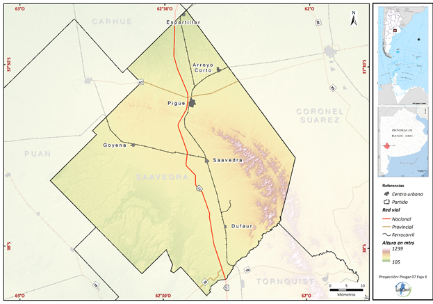
The case study was the town of Pigüé, located in the district of Saavedra, in the southwest of the province of Buenos Aires, at an altitude between 280 and 300 meters above sea level (Figure 1). This locality is a representative case of medium-sized cities, due to its population, functioning and structure. The area falls within the limit of the dry pampas, with a mean annual precipitation value of 702 mm and a mean annual temperature of 14°C (Benedetti et al., 2016). It is located within the pampean phytogeographic region represented mainly by grasslands, a region that is totally modified by man. Thus, the sectors of the plains where agricultural activity has not prospered are populated with species that make up the Pampean grassland, such as Cortaderia selloana, some grasses of the genus Festuca and different varieties of Stipa brachychaeta, Stipa neesiana, Paspalum quadrifarium, among others.
The implementation and design of a Geographic Information System (GIS) involves planning a series of strict steps to achieve a model of reality with quality information that can be extrapolated and even used by managers and decision makers. Olaya (2020) argues that a GIS must consist of three basic stages: A. the establishment of a geographic model; that is, a conceptual model of the geographic reality and its behavior, B. the establishment of a representation model; that is, a way of collecting the previous conceptual model and its own characteristics, reducing it to a finite series of elements and C. the establishment of a storage model; that is, a scheme of how to store the different elements of the representation model.
For the present work, a geographic model of discrete entities was used, which conceives of a geographic environment as an empty space in which different elements (entities) fill it. Each of these entities has its own characteristics, constant for all of them (Olaya, 2000).
The representation model was based on a vector model, which does not divide the space completely, but defines it by means of a series of geometric elements with associated values, the arrangement of which is not systematic (Olaya, 2000). The spatial component consists of a series of points with different degrees of complexity depending on the detail to be worked. This set of points is related to a series of values, which define the properties of the entity (Olaya, 2000).
The storage model used was the arc-node defined by two fundamental units, the nodes, which are points where several lines are connected; and the arcs, which are lines between two nodes (Olaya, 2000).
Once the models to be used were defined, the work was divided into different phases or stages.
Stage 1: Preparation
a. Systematic review of the available documentation oriented to the urban trees of the city and cartographic bases of the urban area. The consultation of both bibliography and cartography revealed some problems. Related to the first one, there were few census documents specified by individuals; and as for the cartographic base, digital parceling with spatial geo-referencing of the parcels was necessary.
b. Interview with local agents: In this interview the immediate needs of the municipality were defined. The need for infrastructure information was expressed, such as enclosure sidewalks, cables in relation to the tree, enclosures. Given that the objective of an urban tree census is to determine the current state of the trees in a locality and this implies answering two basic questions: what species are there and where are they located, it was decided to incorporate variables that respond to these needs.
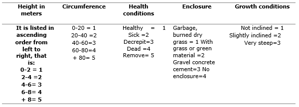
c. Preparation of the survey form: Municipal inventories of urban trees should include information on the number of trees, species or varieties, dimensions, approximate age, health status and location of the trees with reference to specific elements of the urban space. Given the municipal requirements, a form was prepared with the data to be collected and defined with the following data: scientific and common name, height in meters (0-2, 2-4, 4-6, 6-8 or more than 8 meters), DBH (diameter at breast height), health conditions (good, diseased, decrepit and dead). It was also noted whether it should be removed directly because of its condition. The condition of the enclosures or pots was reported, specifically taking into account their size and whether they had garbage, dry grass or debris. Another item in the survey was linked to the conditions of growth in terms of its inclination and other observations of the urban environment such as interference of cables, damage to sidewalks, interference in lighting fixtures, interference in roofs or walls, among others (Benedetti et al., 2014).
d. Standardization of data for inclusion in the geo-database. Setting up a geographic database is a complex task, even more so if the data to be loaded come from different sources or from surveys in which several people participate. For this reason, when designing and implementing a GIS it is extremely necessary to establish guidelines to complete the attribute tables, that is, to standardize the geographic information. The most common problems are the modifiable spatial units, which consists of having different results depending on how the spatial units used to collect information are defined, especially when working with non-natural delimitations. It is well known that GIS attribute tables are alphanumeric and sensitive to alterations, which, when incorrectly loaded, lead to failures in the model. Thus, for example, a period, a comma, a space, and the use of upper or lower case letters are considered as different attributes. For this reason, it was decided that each census taker should carry out the survey with numerical codes as shown in Table 1 (Table 1).
e. Workshop: The survey of trees should be carried out by trained people, since one of the steps is to recognize the species to be surveyed, or to correctly establish the health conditions of the species. It is also necessary to hold small diagnostic workshops. The purpose of these workshops is to agree on how to complete the forms and carry out the survey. It was agreed in this workshop to survey all the addresses even if there are no trees and to survey the condition of the sidewalks. It was also agreed on how to define the state of health of the species surveyed.
f. Field work: As with all field work, prior planning is required. On the one hand, it is necessary to coordinate the form of data collection and the role of each member. In this sense, each census taker was assigned certain blocks. The survey was carried out from the central blocks to the periphery. On the other hand, it is essential for the GIS specialist to be informed about who took the census in each block. The first tree survey was carried out among all the census takers to avoid errors. At the end of each day, a meeting was held to discuss the problems encountered.
g. Design phase of the logic model: 1. Cadastre (provided by the municipality and based on photogrammetric flights of the National Geographic Institute). For the design of the logic model it is necessary to have the spatial base, in this case the geo-referenced cadastre. Since most of the cadastres are in CAD format, it was necessary to convert DraWinG (dwg), which is a computerized drawing file format, to Shape (shp), which is a computerized spatial data file format. Then, it was then necessary to define the projection and the coordinate system, which in this case was the World Geodetic System 84 (WGS84). The trees were worked on the basis of a layer of points associated with the cadastre. (Table 2) 2. The construction of the attributes is a complex task, even more so if there are several agents carrying out the census. Each agent completed the table following the protocol designed by the GIS specialist. The latter assigned an identifying code to each person and the metadata was completed. It was necessary to define the fields and task in charge of the GIS specialist.

RESULTS AND DISCUSSION
Geographic information systems are theoretical-methodological tools that allow thinking, acting and making decisions spatially. The possibility of combining information is substantial in land management. Decision-making about it requires having a model, with standardized and quality geographic information, that adapts to the needs of the territory and management purposes (Barragán et al., 2019).
From the tree census, 9581 spaces were surveyed, of which 1417 corresponded to empty spaces, i.e., there are no trees and the enclosures are present, but empty, or the sidewalks of the plots do not have enclosures. The number of trees and shrubs amounts to 7000 trees and shrubs (individuals) (Benedetti et al., 2014). Of the 1417 vacant spaces recorded (Figure 2) 439 are located in the northern sector, 483 in the southern sector and the rest in the city center. The town has two perpendicular avenues that are the structuring axes of the city, Mitre and Casey avenues. Both avenues have individuals on the boulevard and on the sidewalks, however, towards the ends of both avenues there are more empty spaces, mainly at the end of Mitre Avenue towards the south (Figure 2). It should be noted that the planned neighborhood in the eastern sector has very few empty spaces and the species are young. The spaces without species could be easily occupied since many of them have enclosures made and are empty. The planting of individuals in these spaces would lead to a more functional urban architecture and would help to break the monotony of the urban landscape, especially in the planned neighborhoods.

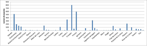
Figure 3 shows the number of tree species in Pigüé. The species that dominate the local tree population are Robinia pseudoacacia L., Fraxinus americana L. and Lagerstroemia indica. The Lagerstroemia indica has a total of 800 individuals, followed by Fraxinus americana L (559) and Robinia pseudoacacia L (520). Although, these are the species that dominate the woodland, it presents an important specific diversity (Figure. 3) (Benedetti et al., 2014), with different types of acacias, walnut trees, willows, lindens, among others. Table 3 presents the representative genera of the alignment woodland. It is highlighted that most of the species have deep roots and are horizontally anchored, which is why sidewalk breaks do not reach a significant percentage.
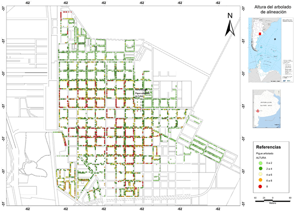
The height of the trees and their diameter are indicators of the age of the species. In general, it is a locality with young trees. Forty-nine percent of the species are between 0 and 4 meters in height with diameters of less than 60 cm. Twenty-six percent of the species are older and have a height of 8 meters or more (Figure 4). Of the total dominant Lagerstroemia indica, 518 are 0 to 2-meter species (Figure 5), i.e. the youngest species which are found in the north. There are 580 individuals from 2 to 4 meters that are located south of Casey Ave. 173 species are from 4 to 6 meters and 112 from 6 to 8 meters. The latter are located mainly in the center of the city and coincide with the historical sectors. In tree management, it is important to control adult species between 6 and 8 meters, as these require intensive care, for example, pruning to avoid weakening their structure.
Table 3. - Most representative genera of the alignment tres
| Genera | ||||
|---|---|---|---|---|
| Abelia | Cercis | Gingko | Morus | Broom |
| Acacia | Chorisia | Hebe | Nerium | Rhus |
| Acer | Cutter | Hibiscus | Olea | Robinia |
| Ailanthus | Crataeus | Jacaranda | Phitolacca | Rosa |
| Araucaria | Cupressuss | Juglans | Phitosporum | Salix |
| Bauhinia | Eriobotrya | Lagerstroemia | Photinia | Schinus |
| Betula | Erythrina | Lavandula | Pinus | Sofora |
| Brachychiton | Eucalyptus | Ligustrum | Platanus | Syringa |
| Buxus | Ficus | Liquidambar | Populus | Thuya |
| Callistemon | Firmiana | Manihot | Prunus | Tilia |
| Catalpa | Fraxinus | Melia | Querqus | Ulmus |
| Viburnum | ||||
| Yucca |

The state of health of the tree is a key to management. The also called phytosanitary status of the tree refers to the presence or absence of pests, diseases and the state of vigor.
Of the total number of areas with species, 7424 are in good health, that is, free of pests and diseases, and most of them have good vigor. However, 224 are sick and 123 are in a decrepit state. Ants, eaten leaves, aphids, fungi and others have been observed. These individuals do not have a specific distribution pattern (Figure 6). However, it is observed that there are several continuous individuals with some type of affection, which would indicate situations of infection. In this regard, it is important to note that there are 88 individuals that should be removed due to poor sanitary conditions or danger of falling. It should also be noted that there are 6 dead individuals, which, although they are not in danger of falling, do not fulfill any function.
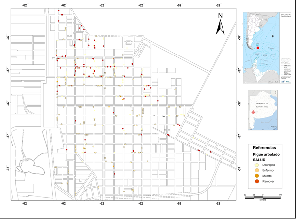
Monitoring, maintenance and pruning of the species must be on the agendas of the municipalities. The lack of planning and management in these matters could lead to serious consequences, such as accidents or death of specimens. It should not be forgotten that pruning is an aggression to the tree, which produces wounds in the bark tissues and leads to greater vulnerability to the presence of pests or weeds. Pruning, if necessary, should be carried out by technical specialists, since if it is done incorrectly, the individual will decay from the branches involved to the trunk and thus, an irreversible process that leads to the death of the specimen.
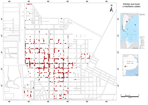
Pruning should be limited to what is strictly necessary and without altering in any way, except in cases that is needed, the characteristic shape of the plants. In other words, the morphology of the tree should be maintained in order to maintain a balance between the root system and the aerial part of the plant at the moment of its implantation, to adapt the crown to vehicular and walker traffic, overhead wiring, street lighting, and to maintain the shape and health of the tree (Núñez, 2001). Pigüé's urban trees have a high percentage of trees that obstruct or interfere with the wiring of public services. Figure 7 shows that most of them are located south of Casey Avenue, which corresponds to the historic center of the town.
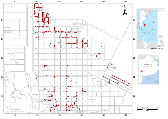
In the urban fabric, the condition of the sidewalks is a fundamental element for the management and planning of trees. According to the survey carried out, 23% of the town's sidewalks are made of clay. Most of these sidewalks are located in three distinct sectors of the city, the first with the largest number is to the north (Figure 8), and area with planned housing that is no more than 20 years old. The other sector is located to the south of the town (Figure 8). It is towards this area where occupation has occurred in recent years. The third sector is located to the east and, as in the previous case, is an area of planned housing, being an expansion zone of the city.
CONCLUSIONS
Urban tree management plans are fundamental in the management of public spaces. Having a census that helps to identify characteristics of diversity, health, height and others allows decision makers to manage them efficiently. The urban tree census carried out in the town of Pigüé made it possible to establish the state of the vegetation in terms of health and conservation, and to determine the places where it should be replaced, as well as the selection of the necessary species. The database obtained from the census and systematized in the GIS will allow the corresponding authorities to make decisions according to the needs of the trees. The town of Pigüé has a high diversity of tree species. In general, the state of health is good, and a continuous management plan is proposed that will allow appropriate decisions to be made, for example, to remove species in poor condition, replace individuals, manage empty spaces and, mainly, a pruning plan for the specimens.
The good management of trees will allow obtaining key benefits for the locality achieving a configuration and management of public spaces that allow improving the landscape beautification, regulating temperatures, improving air quality, enhancing properties, and increasing cultural contributions, among others.
REFERENCIAS BIBLIOGRÁFICAS
ABELL, R., THIEME, M.L., REVENGA, C., BRYER, M., KOTTELAT, M., BOGUTSKAYA, N., COAD, B., MANDRAK, N., BALDERAS, S.C., BUSSING, W., STIASSNY, M.L.J., SKELTON, P., ALLEN, G.R., UNMACK, P., NASEKA, A., NG, R., SINDORF, N., ROBERTSON, J., ARMIJO, E., HIGGINS, J. V., HEIBEL, T.J., WIKRAMANAYAKE, E., OLSON, D., LÓPEZ, H.L., REIS, R.E., LUNDBERG, J.G., SABAJ PÉREZ, M.H. y PETRY, P., 2008. Freshwater ecoregions of the wrld: A new map of biogeographic units for freshwater biodiversity conservation. BioScience, vol. 58, no. 5, pp. 403-414. ISSN 0006-3568. DOI 10.1641/B580507. [ Links ]
APUD, A., ISABEL, D. y COMMONS, C., 2020. Evaluación de la diversidad clásica y funcional del arbolado urbano de la ciudad de La Rioja, Argentina. Universidad Nacional de Quilmes, RIDAA. Maestría en Ambiente y Desarrollo Sustentable. https://ridaa.unq.edu.ar/handle/20.500.11807/2580?show=full [ Links ]
BARRAGÁN, F., LAFFEUILLADE, L., ARIAS, J., PALMEYRO, L., VIDAL QUINI, N.E., GERALDI, A. y ANGELES, G., 2019. Documento para la consecución de una red vial de calidad para estudios geográficos según los parámetros IDESoB. XIII Jornadas de IDERA. Argentina [en línea].: s.n., pp. 201-218. Disponible en: https://www.researchgate.net/publication/343776045_Documento_para_la_consecucion_de_una_red_vial_de_calidad_para_estudios_geograficos_segun_los_parametros_IDESoB. [ Links ]
BARRAGÁN, F.G., 2014. Factibilidad geográfica para la implementación de cultivos no tradicionales en el Partido de Coronel Rosáles, Buenos Aires. Una aproximación a través del uso de Geotecnologías [en línea]. S.l.: Universidad Nacional del Sur. Departamento de Geografía y Turismo. [Consulta: 21/05/2021]. Disponible en: Disponible en: http://repositoriodigital.uns.edu.ar/handle/123456789/3255 . [ Links ]
BENEDETTI, G. y CAMPO, A., 2007. Arbolado de alineación: El mapa verde de un barrio en la ciudad de Bahía Blanca. Argentina. Papeles de Geografía. 45-46 ; pp. 27-38. Disponible en: https://www.redalyc.org/articulo.oa?id=40704602 [ Links ]
BENEDETTI, G., GERALDI, A. y DUVAL, V.S., 2014. Arbolado urbano de la localidad de Pigüé, partido de Saavedra. Planificación y gestión del espacio verde público. Congreso II Jornadas Nacionales de Medio Ambiente Tandil, Agentina: UNICEN, [en línea]., pp. 205. [Consulta: 21/05/2021]. Disponible en: Disponible en: https://www.conicet.gov.ar/new_scp/detalle.php?keywords=&id=45186&congresos=yes&detalles=yes&congr_id=7973749 . [ Links ]
BENEDETTI, G.M., DUVAL, V.S. y CAMPO, A.M., 2016. Propuesta para el análisis de cobertura del arbolado urbano. Caso de estudio: Pigüé, provincia de Buenos Aires. Proyecciones. 10:244-258. ISSN 1852-0006. https://www.researchgate.net/publication/324918669_Propuesta_para_el_analisis_de_cobertura_del_arbolado_urbano_Caso_de_estudio_Pigue_provincia_de_Buenos_Aires [ Links ]
BUZAI, G.D., 2011. Modelos de localización-asignación aplicados a servicios públicos urbanos: análisis espacial de Centros de Atención Primaria de Salud (caps) en la ciudad de Luján, Argentina. Cuadernos de Geografía: Revista Colombiana de Geografía, vol. 20, no. 2, pp. 111-123. ISSN 0121-215X. DOI 10.15446/rcdg.v20n2.27184. [ Links ]
DUVAL, V. y BENEDETTI, G., 2017. Diagnóstico del arbolado público del entorno de la Universidad Nacional del Sur, Bahía Blanca. Libro de la Junta de Geografía 2017 [en línea]. S.l.: Junta de Geografía de la Provincia de Corrientes., pp. 5-17. ISBN 978-987-46760-0-9. Disponible en: https://www.researchgate.net/publication/324223505_Diagnostico_del_arbolado_publico_del_entorno_de_la_Universidad_Nacional_del_Sur_Bahia_Blanca. [ Links ]
FUENZALIDA, M., BUZAI, G.D. y GARCÍA DE LEÓN, A., 2015. Geografía, Geotecnología y Análisis Espacial: Tendencias, métodos y aplicaciones. S.l.: s.n. ISBN 9789569539015. [ Links ]
GERALDI, A., PICCOLO, C. y PERILLO, G., 2010. Delimitación y estudio de cuencas hidrográficas con modelos hidrológicos. Investigaciones Geográficas. vol. 16, no. 30, pp. 215-225. ISSN 2011-2742. DOI 10.4067/S0718-09342002005100014. [ Links ]
GERALDI, A.M., 2009. Estudio geoambiental de la cuenca lagunar las encadenadas del oeste. S.l.: Tesis doctoral. Universidad Nacional del Sur. https://repositoriodigital.uns.edu.ar/handle/123456789/2233 [ Links ]
JAMES, P., TZOULAS, K., ADAMS, M.D., BARBER, A., BOX, J., BREUSTE, J., ELMQVIST, T., FRITH, M., GORDON, C., GREENING, K.L., HANDLEY, J., HAWORTH, S., KAZMIERCZAK, A.E., JOHNSTON, M., KORPELA, K., MORETTI, M., NIEMELÄ, J., PAULEIT, S., ROE, M.H., SADLER, J.P. y WARD THOMPSON, C., 2009. Towards an integrated understanding of green space in the European built environment. Urban Forestry and Urban Greening. vol. 8, no. 2, pp. 65-75. [Consulta: 21/05/2021]. ISSN 1618-8667. DOI 10.1016/j.ufug.2009.02.001. Disponible en: Disponible en: https://www.sciencedirect.com/science/article/pii/S1618866709000144 . [ Links ]
KOWARIK, I. y KÖRNER, S., 2005. Wild urban woodlands: New perspectives for urban forestry. Springer ISBN: 978-3-540-26859-8 no. January 2005, pp. 1-299. DOI 10.1007/b138211. [ Links ]
NÚÑEZ, C.O., 2001. El arbolado público urbano: Consideraciones básicas para su gestión. Voces de la Universidad, vol. 5, no. 24, pp. 21-23. ISSN 1515-1042. [ Links ]
OLAYA, V., 2020. Sistemas de Informacion Geografica. S.l.: s.n. ISBN 9788578110796. Silviculturae Mendelianae Brunensis (Vol. 53, Número 9). http://publications.lib.chalmers.se/records/fulltext/245180/245180.pdf%0A, http://dx.doi.org/10.1016/j.jsames.2011.03.003%0A, https://doi.org/10.1016/j.gr.2017.08.001%0Ahttp://dx.doi.org/10.1016/j.precamres.2014.12 [ Links ]
TOVAR CORZO, G., 2007. Manejo del arbolado urbano en Bogotá. Territorios [en línea], no. 16-17, pp. 149-174. ISSN 0123-8418. Disponible en: https://www.researchgate.net/publication/28313178_Manejo_del_arbolado_urbano_en_Bogota. [ Links ]
ZURITA ESPINOZA, L., 2011. La Gestión del Conocimiento Territorial - Grupo Editorial RA-MA [en línea]. España: RaMa. [Consulta: 21/05/2021]. Disponible en: Disponible en: https://www.ra-ma.es/libro/la-gestion-del-conocimiento-territorial_48640/ , Disponible en: https://www.ra-ma.es/libro/la-gestion-del-conocimiento-territorial_48640/ . [ Links ]
Received: February 18, 2021; Accepted: October 07, 2021
 Este es un artículo publicado en acceso abierto bajo una licencia Creative Commons
