


Mi SciELO
 Servicios personalizados
Servicios Personalizados
Revista

Articulo
 texto en
  Inglés (pdf)
 Articulo en XML
 Referencias del artículo
 Enviar articulo por email
Indicadores
-
 Citado por SciELO
Links relacionados
-
 Similares en
SciELO
Similares en
SciELO
Compartir

 Permalink
Revista Cubana de Ciencias Forestales
versión On-line ISSN 2310-3469
Rev cubana ciencias forestales vol.9 no.3 Pinar del Río sept.-dic. 2021 Epub 08-Sep-2021
Original article
The urban wasteland as alternative to create green areas in Texcoco, Mexico

1Posgrado en Ciencias Forestales, Colegio de Postgraduados. México.
2División de Ciencias Forestales, Universidad Autónoma Chapingo. México.
The creation of urban green areas is affected by rapid population growth and the consequent change in land use, despite the fact that green areas are fundamental for providing ecosystem services. The objective of this study was to analyze the conversion of urban wasteland spaces into green areas. The surface of green area per inhabitant (m2 AV h-1) existing in the city of Texcoco was estimated and wasteland spaces were identified through satellite images. Some soil properties were analyzed to determine the feasibility of establishing vegetation, and a survey was applied to a representative sample of the population to know the social perception of urban green areas. It was found that the city of Texcoco has 0,649 m2 AV h-1. Eighty-four wasteland spaces with potential for conversion into green areas were located, with a total area of 778,601.91 m2, which corresponds to 13.42 % of the city. The proposed conversion would achieve 7.38 m2 AV h-1. In general, the surveyed population shares the idea of creating more green spaces in the city of Texcoco, however, economic and political factors should be considered in the future.
Keywords: Planning; Environmental design; Urban spaces; Vegetation; Urban greening.
INTRODUCTION
Urban green areas (UAVs) have been a constant element in cities; at the beginning they responded to the interest of offering outdoor recreational services for the inhabitants, being spaces with different types of vegetation. Nowaday, the implementation of these spaces is part of a comprehensive approach that includes social, environmental and economic aspects. In addition, the emergence of new urban development models during the 19th century, based on the conservation and protection of nature, laid the foundations for sustainable urban planning (Martínez-Valdés et al., 2020). Under this approach, the indicator of 9 m2 AV h-1 arises, a reference value in various technical and scientific texts (Pérez-Medina and López-Falfán, 2015).
UAVs contribute significantly to urban sustainability by providing ecosystem services; however, they present unfavorable conditions for their establishment and conservation within a city (Twerd and Banaszak-Cibicka, 2019). Rapid urbanization, lack of urban planning and weak public policies have resulted in fragmented and inadequately sized UAVs that are unable to provide ecosystem services in quantity and quality, and in some cases become a risk for the population (Krajter-Ostoic et al., 2017). During the urbanization process, the emergence of underutilized elements is observed, such as urban wasteland spaces (EOU) (Brun et al., 2018). Such spaces are dynamic in space and time and are originated by anthropogenic actions such as construction or demolition of infrastructure, variable economic factors of one or more sectors of the population, as well as changes and adaptations in the design of the urban fabric (Twerd and Banaszak-Cibicka, 2019).
EOUs have common characteristics within cities; for example, they are often crime hotspots, are used as garbage dumps, are meeting points for adolescents, or a refuge for local fauna; when they are not altered by human action, they are sometimes recognized as places with ecological importance because they are home to a great diversity of plants and insects (Nejman et al., 2018). EOUs, when influenced by anthropogenic factors, are considered urban land (Guilland et al., 2018) and, regardless of their alteration, represent an alternative use for the creation of UAVs.
The general objective of this research was to analyze the conversion of urban wasteland spaces into urban green areas in Texcoco´s city, for which the following specific objectives were considered: a) to locate and prioritize the wasteland spaces in the city of Texcoco; b) to evaluate the physical and chemical characteristics of urban soil in wasteland spaces, as a fundamental factor in the establishment of vegetation; c) to estimate the green area per inhabitant for the city of Texcoco; and d) to establish the perception and social participation of the population on the UAVs. The hypothesis is that the EOU present diverse physicalchemical characteristics in the soil that allow the establishment of vegetation, likewise, the use of the EOU, makes it possible to increase the green area in the city of Texcoco, since the people who visit the AVUs in the city, show an interest in making use of the EOU as AVU, being a key piece in their management and maintenance.
MATERIALS AND METHODS
In the present study, a quantitative approach was contemplated through various spatial analysis techniques and the use of statistical analysis.
Location of the study area
The city of Texcoco is located 23 km east of Mexico City (Figure 1) and is part of the 9 Cuautitlán-Texcoco Valley in the State of Mexico, Mexico.

The city of Texcoco is located between the geographic coordinates 19°30'48.28''N and 13 98°52'53.58''W, and is composed of 19 sectors with an approximate area of 580 ha; it has 14 a population as of 2020 of 35,491 inhabitants according to the National Institute of 15 Statistics and Geography, INEGI (www.inegi.gob.mx). The city has an average altitude of 16 2,246 m; it has a semi-dry temperate climate with an average annual temperature of 15.9 17 °C and an average annual rainfall of 686 mm; the soil is mostly Vertisol with predominantly 18 urban use (Gutiérrez and Ortiz, 1999). The urban core has an AVU area of 75 097 m2 as of 19 2015 according to the H. Ayuntamiento.
Delimitation of wasteland spaces
The city of Texcoco was delimited with the help of Arc Gis 10.2® software from information provided by the H. Ayuntamiento; a layer was generated in KML (Keyhole Markup Language) format and visualized jointly and correctly geo-positioned with the satellite images (SI) provided by Google Earth® (GE) software. With the help of GE's "image history" module, IS between 2001 and 2015 within the study area were reviewed and spaces with no apparent use (EOU) were located. Finally, a database was generated with information corresponding to identification, location and surface area (Freire, 2011).
The Analytic Hierarchy Process (AHP) method (Saaty, 1994) was used to evaluate the feasibility of converting EOUs into UAVs. Based on information from five criteria taken from the literature review on the use of urban spaces for the creation of UAVs: area of influence (VI); access to space (VA); property for sale (VP); municipal property (VM) and school property (VE); a hierarchy of "potential use" was established with four levels (priority, high, medium and low). The criteria were evaluated on a scale of 0 to 3 points, whereby an EOU with a high PT presents a better potential for conversion to AVU under the aforementioned criteria (Handley et al., 2003).
Urban soil condition
Soil sampling sites were selected based on accessibility to the EOUs (ability to sample without physical restrictions) and some of the existing AVUs were considered to complement the study (January 2015 to March 2015). Samples were placed in a properly labeled bag and immediately taken to the laboratory. On par with the above sampling, a composite sample (MC) [2 kg] was taken from the collection of 10 random sub-samples, which were taken at a depth between 0 and 25 cm; the MCs were dried at room temperature to a constant weight and sieved with a 2 mm mesh.
The bulk density (Dap) of the samples was determined using the waxed clod method. Texture was determined by the touch test; pH was determined in triplicate using a Beckman@ potentiometer in a soil-solution ratio of 1:2, in 0.01 M CaCl2, with a pH of 5.8. Electrical conductivity (EC) was evaluated with a conductivity meter, at a soil-solution ratio of 1:2, measured from the soil extract (dS m-1) (Segura et al., 2000). Organic matter (OM) was also determined through the Walkley and Black method (Eyherabide et al., 2014). Finally, and at a later date (April 2015), the infiltration capacity (mm h-1) was evaluated at each sampling site through the double ring infiltrometer method, the Kostiakov equation was applied and the model parameters were adjusted with the Least Squares method.
Green area per inhabitant
To estimate the square meters of green area per inhabitant (m2 AV h-1), the modified Maleki et al., (2012) method was used, which consists of evaluating four criteria: a) average area necessary for the growth of a healthy tree; b) average temperature of the city; c) environmental quality; and d) population density in the study area. The average area necessary (item a) represents an area of 7m2 considered optimal for the growth and development of a healthy tree, while criteria b), c) and d), were evaluated through the review of information in scientific articles on the study area, thus assigning a value to each criterion and proceeding to estimate the m2 AV h-1.
Population and survey
A projection of the inhabitants of the city of Texcoco to the year 2015 was made through censuses and housing population counts from 1990 to 2010 with data from INEGI (www.inegi.gob.mx). With the projected population, the minimum size of the population to be surveyed was estimated using a simple random sampling design with a reliability of 95 %, through the methodology used by Sosa-Martínez et al., (2020). The survey was of a personal type considering "Adolescents", "Youth", "Adults" and "Older adults", in an age range of 15 to 74 years.
The survey was structured with 14 items in three sections: the first one characterizes the sociodemographic information (gender, age, occupation, among others); the second one focuses on the use of UAVs by the population (number of visits, time of visits, purposes of visits, among others); and the third one inquires about the perception and social participation in the creation of UAVs (donations, contributions, labor force, among others).
The survey was applied randomly with homogeneous distribution, so it included green areas, residential areas and city streets; in a schedule from 9 a.m. to 6 p.m. from Monday to Sunday (Brun et al., 2018). It is worth mentioning that through the study area people from surrounding regions arrive to transit daily, so the origin of the respondents did not always coincide with a residence in the city, however, these are part of the AVU users in the city.
Data analysis
An exploratory and descriptive analysis through frequencies and percentages was carried out with the EOU. Soil properties were studied taking into account their cardinal position; when the variables met the assumptions (normality and homogeneity), an analysis of variance (ANOVA) was carried out and the means were compared with Tukey's DSH test. When the assumptions were not met, the variables were transformed using the Box-Cox method. Finally, the survey information was studied with correspondence analysis (CA) using R software (R Core Team, 2019).
RESULTS AND DISCUSSION
Delimitation of urban wasteland spaces
There were 84 EOUs with a total area of 778,601.91 m2, representing 13.42 % of the study area. Of these, 17 sites have a "priority" conversion potential, with a total area of 86 834.73 m2 (1.49 %); 28 sites have a "high" conversion potential, with a total area of 622 945.27 m2 (10.74 %); 32 sites have a "medium" conversion potential and a total area of 60 985.23 m2 (1.05 %) and finally, 7 sites belong to the "low" potential with a total area of 7 836.68 m2 (0.14 %) (Figure 2A).
A large part of the EOUs found in the study area can be used as green spaces, since they have characteristics that are favorable for their conversion into AVUs; however, public policies and the way the city's budget is allocated limit their implementation.
It was observed that the EOU tend to be located in the periphery of the study area (Figure 2A), possibly due to a loss in the cadastral value and therefore, they tend to fall into disuse outside the area with greater economic activity (downtown area), consequently, they are the lands away from the urbanization process. This condition favors their use and conversion into UAVs, which cushions the expansion of the urban specks (Krajter-Ostoic et al., 2017).
Of the 84 EOUs ranked, 63 were found in property for sale (VP), 19 in municipal property (VM) and 2 in school property (VE) (Figure 2B). It is worth mentioning that "property for sale" indicates the possibility of acquiring the EOUs through a sales contract and not that they are for sale. It should be noted that green spaces provide environmental benefits mainly when they have an area larger than 10 ha (Gámez, 2005), in this case, only two properties exceed 10 ha, however, it is an opportunity to promote the creation of UAVs and avoid urban agglomeration.
Physical-chemical condition of urban soil
Soil samples were collected at 14 sites, with their respective infiltration tests; the sampled areas presented a homogeneous distribution within the study area (Figure 2A).
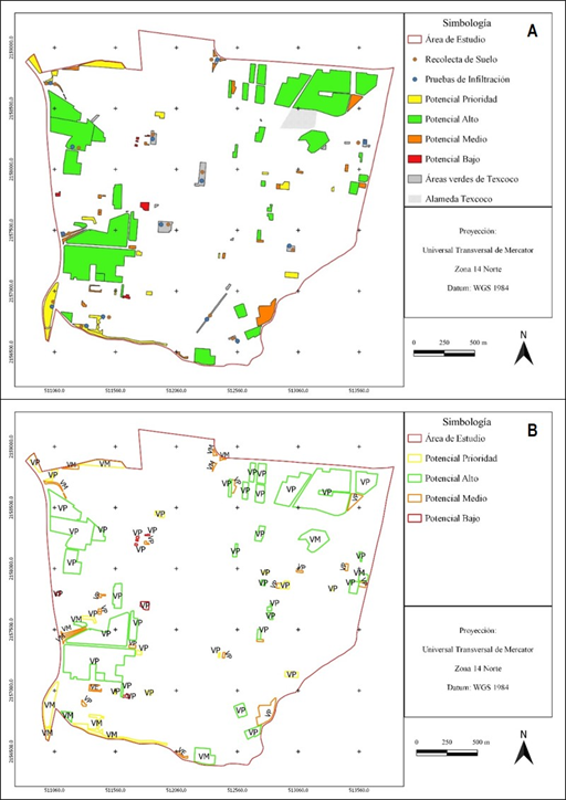
Fig. 2. - EOU hierarchy (A) and EOU land ownership (B), where VP indicates "Property for sale", VM indicates "Municipal property" and VE indicates "School property"
Statistical differences (P < 0.05) were found in the Dap, the values were located in a range of 1.26 Mg m-3 in its highest value and 1.05 Mg m-3 in its lowest value (Figure 3A). The soils with the highest Dap were located in the cardinal point "east" of the study area, despite these conditions; there is no significant restriction to root growth. The United States Department of Agriculture (USDA) indicates that only densities greater than 1.47 Mg m-3 cause a restriction in the growth of the root system, affecting plant development.
The variation in the Dap between cardinal points may be due to the fact that there are areas of the city with greater movement of people, although in general, the low intensive use (pedestrian traffic or machinery) of the EOUs has ensured that they maintain an acceptable Dap, which allows the adequate establishment of vegetation according to the USDA.
Studies on soil compaction due to the use of pack animals (Bubalus bubalis) on forest roads and heavy machinery in agricultural fields have shown an average Dap of 1.07 Mg m-3 and 1.5 Mg m-3 respectively, making it evident that the use of machinery is one of the factors that could contribute to a greater extent to soil compaction and not always with the passage of people or pack animals (Villalobos-Barquero and Meza-Montoya, 2019).
Soil texture did not show a significant difference, with a predominance of clay texture in the study area. Soil pH showed statistical significance (P < 0.05), the highest value was located in the cardinal point "west" with a value of 8.4 (Figure 3B); it should be noted that the former Lake Texcoco is located in this direction, whose soils have saline-sodic characteristics, being classified as "moderately alkaline", which can be a limiting factor in urban greening plans (Gutiérrez and Ortiz, 1999).
Statistical difference (P < 0.05) was found in the EC, the highest value was in the cardinal point "west" (ex Lake Texcoco) with 3.25 dS m-1(Figure 3C), where some of the EOU and surrounding areas presented strongly developed aggregates and crusts indicating high salt concentration, which prevents vegetation growth (characteristics of the soil of lacustrine origin) (Segura et al., 2000). Values between 0 and 0.8 dS m-1 are acceptable for vegetation growth, mainly in agricultural crops as indicated by the USDA; however, it is a good reference for the establishment of other types of vegetation.
The excess of salts in the soil inhibits plant growth, this is mainly due to two situations, the first is through a lower water potential in the soil solution, affecting the availability of water (water stress); the second produces ionic stress which can cause toxicity. There are alternatives for the establishment of vegetation under salinity conditions such as those found in the cardinal point "west", and they are: Distichlis spicata, Suaeda nigra, Kochia scoparia and Tamarix chinensis and Tamarix aphylla(Segura et al., 2000).
On the other hand, the MO showed significant differences between sites (P < 0.05), the highest value was presented in the cardinal point "south-east" with 6.80 %, being almost twice as high as in the cardinal point "north" with 3.87 %; while the lowest value of MO was found in the "west", with a value of 0.75 % (Figure 3D).

The bars indicate the standard deviation. Equal letters mean statistically equal means
Fig. 3. - Physical and chemical properties of the soil, analyzed in different cardinal points of the city of Texcoco
Infiltration was not significant (P > 0.05), given the type of clay soil, the range of water infiltration should be between 1 mm h-1 and 5.1 mm h-1, however, values related to loam soils (5.1 to 10.2 mm h-1), and sandy and silty soils (10.2 to 20.3 mm h-1) according to the USDA were found (Figure 3E).
It was observed that in the cardinal point "north", there are water infiltration problems, which could be a limiting factor for the establishment and development of vegetation. The infiltration capacity of a soil is affected by its physical, chemical and biological characteristics; therefore, infiltration is altered by the development of roots, earthworm excavations, soil aggregation, as well as by the increase of stable organic matter. Given that the areas where infiltration was evaluated have not presented any kind of management over time (±10 years), water infiltration is only affected by the intrinsic condition of each EOU.
Green area in the city of Texcoco
The evaluation of the four criteria revealed that the city of Texcoco should have 14m2 AV h-1(Maleki et al., 2012), however, the surface of 75 097 m2 of green areas and a population calculated as of 2015 of 115 755 inhabitants, indicates that it has 0.649 m2 AV h-1, being a value far below that suggested in publications on the subject. The green area per inhabitant has been determined in several cities around the world with the objective of reaching or exceeding the standard value of 9 m2 AV h-1, under a sustainable development approach. In some European Union countries, values vary between 4 and 200 m2 AV h-1. Contrary to this, in some Latin American countries, for example, in the city of Córdoba, Veracruz, Mexico, a value of 4.02 m2 AV h-1 was found (González-Kuk et al., 2019), while the metropolitan area of Santiago de Chile (South America), presented an average of 3.2 m2 AV h-1, with the characteristic that areas of low economic resources reached 0.4 m2 AV h-1; despite this, there are outstanding examples such as the city of Curitiba in Brazil (Reyes and Figueroa, 2010).
The use of the EOU identified in this work represents an option to achieve a higher UVA value in the city, which will allow, to the extent possible, to cushion the effect of urban sprawl and the associated environmental effects. Considering the above, the use of the EOU of the "priority" group would represent a contribution of 0.75m2 AV h-1, the "high" group would contribute 5.38m2 AV h-1, the "medium" group would offer 0.53m2 AV h-1 and finally, the "low" group would only contribute 0.07m2 AV h-1, reaching up to 7.38m2 AV h-1.
The standard value of green area is a starting point towards urban greening; however, the creation of AVU must consider factors related to the environment (carbon sequestration, oxygen supply, regulating infiltration processes, among others), the tastes and preferences of the population (social demand), as well as benefit-cost aspects (economic). The above, will define a typology of AVU and will allow establishing green surface standards in an integral and inclusive way that are universal, stable and practical (Gámez, 2005; Flores Xolocotzi, 2017).
Population and survey
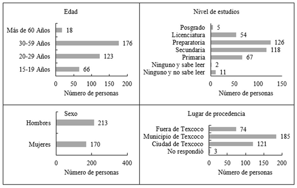
The main characteristics of the population are shown in Figure 4. A total of 383 respondents were obtained (56 % male and 44 % female), finding that 17.2 % were located in the "Adolescents" group, 32.1 % in the "Youth" group, 45.9 % in "Adults" and 4.6 % in the "Older Adults" group. It was observed that 48 % of the respondents live somewhere within the municipality of Texcoco (in one of the 19 sectors and 60 localities), while only 32 % live in the city of Texcoco.
On the other hand, the correspondence analysis (CA) showed the trend of the responses of the surveyed population (Figure 5). Within the first section of the survey (characterization of the population), it was identified that the group of "Adults" was related to residences outside the city of Texcoco and basic education. The responses of the "Young people" indicated that they have mostly high school and higher education, and the "Older adults" were characterized by being associated with low income (Figure 5F).
In the second section (use of urban green areas), it was found that respondents make use of green areas in the company of family members (46 %), to take a break or recreation (38 %), without a defined schedule. It was observed that "Adolescents" were related to play and socialization activities (visiting with friends), with a moderate length of stay in the AVU, while "Young people" presented a tendency to intensive use of the green space (recreation, socialization, leisure), with stays that can reach 60 minutes, with a weekly frequency and in an evening visit schedule.
1 As for the "Adults" group, it was located near the reading and resting activity with a low 2 frequency of weekly visits in the morning. Finally, "Older adults" were related to a daily 3 visit frequency, being above the other groups in terms of visits to the AVUs, however, they 4 have a short duration permanence (Figure 5G). Finally, it was identified that respondents 5 spend only a few minutes in the green areas at night, this may be due to security-related 6 situations.
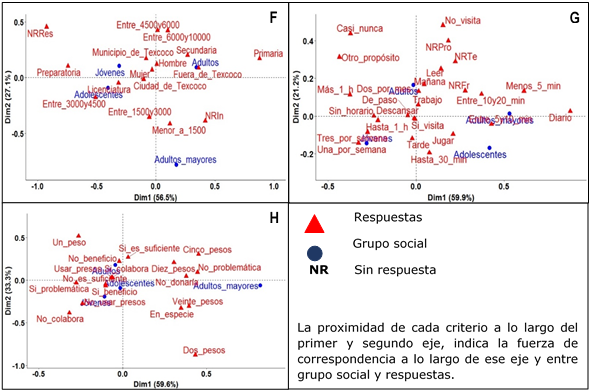
Fig. 5. - Projection of the responses of the surveyed population: Section "Characterization of statistical-social information" (F), Section "Use of UAVs by the population" (G) and Section "Perception and social participation in the creation of UAVs" (H)
The third section (perception of the respondents on AVUs), showed that "Adolescents and Youth" are aware of the benefits that vegetation offers to the urban environment, however, they consider that this is insufficient in the city. The tendency of the responses was towards participation in activities related to the creation of AVUs. The above, opens a window of citizen participation where the inclusion of diverse groups of society will allow homologating and generalizing tastes, preferences and needs, considering social, economic, geographical and environmental differences of cities and their inhabitants, collaborating in an integral way in urban greening projects (Flores-Xolocotzi, 2017).
Regarding the group of "Adults", they indicated that they perceive the amount of green areas in the city as sufficient; their answers were related to not knowing the benefits offered by the AVU and presented a tendency to collaborate in the development of green.
spaces. Finally, the responses of the "Older adults" group showed that they were unaware of the problem of the lack of vegetation in the city and to a greater extent were unaware of the AVU issue, as well as showing no interest in increasing these spaces (Figure 5H).
CONCLUSIONS
It was possible to locate and prioritize 84 EOUs that could be converted into AVUs, with a total area of 778,601.91 m2 and it was identified that the condition of the urban land is not a limiting factor in the establishment of vegetation.
The green surface of the city of Texcoco reaches a value of 0.649 m2 AV h-1 (2015); the conversion of the EOU into AVU, allows reaching a value of 7.38 m2 AV h-1.
From the social point of view, the population considers that the AVUs are necessary and more are needed to serve in "recreational" activities. There is a positive opinion towards the creation of AVUs, which implies an opportunity to take advantage of citizen participation.
An important limitation in the creation of UAVs is the economic resources and the lack of public policies that allow for the fluidity of their management, aspects not addressed in this study but which are relevant in the implementation of UAVs.
ACKNOWLEDGMENTS
The authors would like to thank the Municipality of the city of Texcoco for allowing this work to be carried out. We would also like to thank the personnel working in the soil physics and fertility laboratory of the Soil Department and the Central Laboratory, both at the Universidad Autónoma Chapingo, for their support with the soil analyses.
REFERENCIAS BIBLIOGRÁFICAS
BRUN, M., DI PIETRO, F. y BONTHOUX, S., 2018. Residents' perceptions and valuations of urban wastelands are influenced by vegetation structure. Urban Forestry & Urban Greening [en línea], vol. 29, pp. 393-403. [Consulta: 30/06/2021]. ISSN 1618-8667. DOI 10.1016/j.ufug.2017.01.005. Disponible en: Disponible en: https://www.sciencedirect.com/science/article/pii/S161886671630351X . [ Links ]
EYHERABIDE, M., et al. 2014. Comparison of methods for determining soil organic carbon. Ciencia del Suelo, [en línea] vol. 32, no. 1, pp. 13-19. [Consulta 12/12/2020] ISSN 0326-3169. Disponible en: Disponible en: https://www.cabdirect.org/cabdirect/abstract/20153031211 [ Links ]
FLORES-XOLOCOTZI, R., 2017. Una reflexión teórica sobre estándares de áreas verdes empleados en la planeación urbana. Economía, sociedad y territorio [en línea], vol. 17, no. 54, pp. 491-522. [Consulta: 30/06/2021]. ISSN 1405-8421. DOI 10.22136/est002017682. Disponible en: Disponible en: http://www.scielo.org.mx/scielo.php?script=sci_abstract&pid=S1405-84212017000200491&lng=es&nrm=iso&tlng=es . [ Links ]
FREIRE, T.S. 2011. Los "vacíos urbanos". Causas de su existencia en el suelo urbano de la primera periferia de Madrid. Revista Territorios en Formación [en línea], vol. 1, pp. 61-478. [Consulta: 20/09/2020]. ISSN 2174-8659. Disponible en: Disponible en: http://polired.upm.es/index.php/territoriosenformacion/article/view/1287 [ Links ]
GÁMEZ, B.V. 2005. Sobre sistemas, tipologías y estándares de áreas verdes en el planteamiento urbano. Revista Electrónica DU&P [en línea], vol. 2, no. 6, pp. 1-22. [Consulta 25/01/2021]. ISSN 0717-9758. Disponible en: Disponible en: http://dup.ucentral.cl/pdf/000002.pdf [ Links ]
GONZÁLEZ-KUK, G., MUÑOZ-MÁRQUEZ TRUJILLO, R.A., GARCÍA-ALBARADO, J.C. y GÓMEZ-MERINO, F.C., 2019. Áreas verdes urbanas en Córdoba, Veracruz, cantidad, ubicación y acceso: un análisis ortogonal. Revista mexicana de ciencias agrícolas [en línea], vol. 10, no. 7, pp. 1565-1578. [Consulta: 30/06/2021]. ISSN 2007-0934. DOI 10.29312/remexca.v10i7.1907. Disponible en: Disponible en: http://www.scielo.org.mx/scielo.php?script=sci_abstract&pid=S2007-09342019000701565&lng=es&nrm=iso&tlng=es . [ Links ]
GUILLAND, C., MARON, P.A., DAMAS, O. y RANJARD, L., 2018. Biodiversity of urban soils for sustainable cities. Environmental Chemistry Letters [en línea], vol. 16, no. 4, pp. 1267-1282. [Consulta: 30/06/2021]. ISSN 1610-3661. DOI 10.1007/s10311-018-0751-6. Disponible en: Disponible en: https://doi.org/10.1007/s10311-018-0751-6 . [ Links ]
GUTIÉRREZ C., M.C. y ORTIZ S., C.A. 1999. Origen y evolución de los suelos en el ex lago de Texcoco, México. Agrociencia [en línea], vol. 33, no. 2, pp. 199-208.[Consulta: 10/05/2021]. ISSN 1405-3195. Disponible en: Disponible en: https://agrociencia-colpos.mx/index.php/agrociencia/article/view/1601 [ Links ]
HANDLEY, J., PAULEIT, S., SLINN, P., LINDLEY, S., BAKER, A. y JONES, C., 2003. Providing accessible natural green space in towns and cities. English Nature [en línea], vol. 1, pp. 1-6. Disponible en: http://publications.naturalengland.org.uk/file/78003. [ Links ]
KRAJTER-OSTOIÆ, S., KONIJNENDIJK VAN DEN BOSCH, C., VULETIÆ, D., STEVANOV, M., ŽIVOJINOVIÆ, I., BEÆIROVIÆ, S., LAZAREVIC, J., STOJANOVA, B., BLAGOJEVIC, D., STOJANOVSKA, M., NEVENIC, R. y PEZDEVŠEK MALOVRH, Š. 2017. Citizens' perception of and satisfaction with urban forests and green space: Results from selected Southeast European cities. Urban Forestry & Urban Greening [en línea], vol. 23, pp. 93-103. DOI 10.1016/j.ufug.2017.02.005. Disponible en: https://www.researchgate.net/publication/313554544_Citizens%27_perception_of_and_satisfaction_with_urban_forests_and_green_space_Results_from_selected_Southeast_European_cities. [ Links ]
MALEKI, S., REZAEE, A.A., HATAMI, D. y JADIDOLESLAM, M., 2012. Investigation analysis and proposed per capita for urban Green space (case study) Darab city, Iran. Indian Journal of Innovations and Developments [en línea], vol. 1, no. 12, pp. 803-810. Disponible en: https://www.researchgate.net/publication/342638292_Investigation_analysis_and_proposed_per_capita_for_urban_green_space_case_study. [ Links ]
MARTÍNEZ-VALDÉS, V., SILVA RIVERA, E., GONZÁLEZ GAUDIANO, E.J., MARTÍNEZ-VALDÉS, V., SILVA RIVERA, E. y GONZÁLEZ GAUDIANO, E.J., 2020. Parques urbanos: un enfoque para su estudio como espacio público. Intersticios sociales [en línea], no. 19, pp. 67-86. [Consulta: 30/06/2021]. ISSN 2007-4964. Disponible en: Disponible en: http://www.scielo.org.mx/scielo.php?script=sci_abstract&pid=S2007-49642020000100067&lng=es&nrm=iso&tlng=es . [ Links ]
NEJMAN, R., £EPKOWSKI, M., WILCZYÑSKA, A. y GAWRYSZEWSKA, B., 2018. The right to wild. Green urban wasteland in the context of urban planning. Urban Development Issues [en línea], vol. 59, pp. 43-53. DOI 10.2478/udi-2018-0027. Disponible en: https://www.researchgate.net/publication/328339608_The_right_to_wild_Green_urban_wasteland_in_the_context_of_urban_planning. [ Links ]
PÉREZ-MEDINA, S. y LÓPEZ-FALFÁN, I., 2015. Áreas verdes y arbolado en Mérida, Yucatán. Hacia una sostenibilidad urbana. Economía, sociedad y territorio [en línea], vol. 15, no. 47, pp. 01-33. [Consulta: 30/06/2021]. ISSN 1405-8421. Disponible en: Disponible en: http://www.scielo.org.mx/scielo.php?script=sci_abstract&pid=S1405-84212015000100002&lng=es&nrm=iso&tlng=es . [ Links ]
R CORE TEAM, 2019. R: a language and environment for statistical computing. [en línea]. Vienna, Austria: R Foundation for Statistical Computing. [Consulta: 30/06/2021]. Disponible en: Disponible en: https://www.gbif.org/es/tool/81287/r-a-language-and-environment-for-statistical-computing . [ Links ]
REYES, P.S. y FIGUEROA A., I.M. 2010. Distribución, superficie y accesibilidad de las áreas verdes en Santiago de Chile. Revista Latinoamericana de Estudios Urbano Regionales [en línea] vol. 36, no. 109, pp. 89-110. [Consulta: 18/03/2021]. Disponible en: Disponible en: http://www.eure.cl/index.php/eure/article/view/82 [ Links ]
SAATY, T.L., 1994. Fundamentals of Decision Making and Priority Theory with the Analytic Hierarchy Process [en línea]. S.l.: RWS Publications. ISBN 978-0-9620317-6-2. Disponible en: https://books.google.com.cu/books/about/Fundamentals_of_Decision_Making_and_Prio.html?id=nmtaAAAAYAAJ&redir_esc=y. [ Links ]
SEGURA C, M.A., GUTIÉRREZ C., M.C., ORTIZ S., C.A. y GÓMEZ D., D.J. 2000. Suelos arcillosos de la zona oriente del Estado de México. Terra Latinoamericana [en línea] vol 18, no.1. pp. 35-44. [Consulta: 24/04/2021] Disponible en: Disponible en: https://www.researchgate.net/publication/293555744_Suelos_arcillosos_de_la_zona_oriente_del_Estado_de_Mexico [ Links ]
SOSA-MARTÍNEZ, A., NARCHI, N., ROSA, I., LEAL-BAUTISTA, M., FRAUSTO-MARTÍNEZ, O. y CASAS, D., 2020. Percepción y uso del agua de lluvia por usuarios en una comunidad del Caribe mexicano Perception and Forms of Rainwater Management by Users in a Mexican Caribbean Community. Sociedad y Ambiente [en línea], pp. 1-27. DOI 10.31840/sya.vi23.2166. Disponible en: https://www.researchgate.net/publication/344243955_Percepcion_y_uso_del_agua_de_lluvia_por_usuarios_en_una_comunidad_del_Caribe_mexicano_Perception_and_Forms_ of_Rainwater_Management_by_Users_in_a_Mexican_Caribbean_Community. [ Links ]
TWERD, L. y BANASZAK-CIBICKA, W., 2019. Wastelands: their attractiveness and importance for preserving the diversity of wild bees in urban areas. Journal of Insect Conservation [en línea], vol. 23. DOI 10.1007/s10841-019-00148-8. Disponible en: https://www.researchgate.net/publication/332099287_Wastelands_their_attractiveness_and_importance_for_preserving_the_diversity_of_wild_bees_in_urban_areas. [ Links ]
VILLALOBOS-BARQUERO, V y MEZA-MONTOYA, A. 2019. Impacto en la densidad aparente del suelo provocado por el tránsito de búfalos (Bubalus bubalis) en arrastre de madera. Tropical Journal of Environmental Science [en línea] vol. 53, no. 2, pp. 147-155. DOI: 10.15359/rca.53-2.8. Disponible en: https://www.scielo.sa.cr/scielo.php?script=sci_arttext&pid=S2215-38962019000200147 [ Links ]
Received: June 25, 2021; Accepted: October 18, 2021
 Este es un artículo publicado en acceso abierto bajo una licencia Creative Commons
