


My SciELO
 Custom services
Services on Demand
Journal

Article
 text in
  English (pdf)
 Article in xml format
 Article references
 Send this article by e-mail
Indicators
-
 Cited by SciELO
Related links
-
 Similars in
SciELO
Similars in
SciELO
Share

 Permalink
Revista Cubana de Ciencias Forestales
On-line version ISSN 2310-3469
Rev cubana ciencias forestales vol.10 no.1 Pinar del Río Jan.-Apr. 2022 Epub Apr 04, 2022
Original article
Dynamics of land use change in the Guangras sector of Sangay National Park, Ecuador
1
*
 http://orcid.org/0000-0003-4344-5600
2
http://orcid.org/0000-0002-8313-9176
3
http://orcid.org/0000-0003-2878-9130
4
http://orcid.org/0000-0002-6870-3787
1Universidad de Pinar del Río "Hermanos Saíz Montes de Oca". Facultad de Ciencias Forestales y Agropecuarias. Pinar del Río, Cuba.
2Facultad de Recursos Naturales, Instituto de Investigaciones, Proyecto MARERUS, Escuela Superior Politécnica de Chimborazo. Ecuador.
3Universidad Técnica de Cotopaxi. Ecuador.
4Escuela Superior Politécnica de Chimborazo. Ecuador.
5Centro de Trabajo Centro de Producción Forestal San Andrés. CEPORFSA. Pinar del Río, Cuba.
Land use change studies are very important tools because they evaluate the speed of deforestation/reforestation, determine its geographic extension and comprehend the social and economic causes of the changes at global, regional and local scales. The objective of this work was to analyze land use changes in the Guangras sector, in an area of 1 609.48 ha focused on to the recovery of ecosystem services and biodiversity conservation in the southern zone of the eastern Andean Cordillera within Sangay National Park. A spatio-temporal study was carried out through satellite images, where Landsat images were pre-processed and classified using ArcGis 10.1 software to determine the change in land use and the analysis of the transition matrix. As a result of this geospatial study, five land uses were identified: moorland, agricultural crops, forest, grassland and water bodies, as well as a change dynamic from 1991 to 2016, in relation to the forest, a decrease of 2.47 %, of moorland 0.76 %, of water bodies 0.28 %, while grassland increased by 3.07 %, and agricultural crops by 1.88 %.
Keywords: Satellite images; Vegetation cover; Spatio-temporal study; Degradation; Fragmentation.
INTRODUCTION
Land use change studies are tools of great importance as they assess the speed of deforestation/reforestation, determine its geographic extent and understand what the social and economic causes of the changes, at global, regional and local scales are (Ruiz, Savé and Herrera, 2014).
The use of satellite images and their application in multi-temporal studies using GIS have made it possible to quantify the anthropic changes that have occurred in a given space and in a defined period of time. Thanks to this type of tool, changes in land use and land cover have received greater attention in recent years; these types of studies provide valuable information for environmental decision-making and are of great help as tools for monitoring and quantifying the changes that have occurred in an area of interest over an established period of time (Pimiento, 2019).
This topic has increased interest at present, with the work of Escobar and Castillo, (2021) who analyze the trajectories of land cover and land use change in three watersheds in the Soconusco region, Chiapas, Mexico over a period of 25 years; Sandoval et al., (2021) in a micro-watershed in the Mixteca Alta Oaxaqueña, Mexico during the period from 1995 to 2016; Pérez et al., (2021) in ecosystems of the municipality of San Pablo Cuatro Venados, Zaachila, Oaxaca in the period from 1998 to 2000.
Bonilla-Moheno et al., (2012) point out that research on land cover and land use change at the local level provides appropriate information on the main factors of these modifications; in addition to, incorporating into the analysis details of productive activities at the household level, as well as in the historical and social context.
That is why, counting with an outdated Sangay National Park management plan, which dates back to 1998, brings consequently that the changes that the area has experienced by anthropogenic activities, which have been intense according to Vistín (2018) are not known. This work has the following objective: to analyze the changes in land use of the Guangras sector within Sangay National Park (PNS).
MATERIALS AND METHODS
The study area is located in the forest of the community of Guangras in the Achupallas Parish within the micro-watershed of the Santiago River, located in the province of Chimborazo within the boundaries of Sangay National Park, Ecuador, which is bordered to the north by the Ozogoche micro-watershed, to the south by the province of Azuay, to the east by the province of Morona Santiago, and to the west by the province of Cañar. The projected geographic coordinates UTM Zone 17S, DATUM WGS 84 are Latitude South 765693 and Longitude East 9726656 (Figure 1).

For the classification of land use and the changes that occurred during the period 1991-2016, two Landsat 5 images obtained in 2016 during the dry season with a cloud cover of 10 % (path/row: 10/62), remote sensing techniques, and the use of Geographic Information Systems (GIS) were used. The following land uses were determined: Forest, Water bodies, Crops, Grassland, Plantations and Moorlands in the dates January and 1991 November of 2016.
The satellite images for the selected dates were obtained from the United States Geological Survey (USGS) website. Earlier dates were selected because of the scarcity of images without cloud cover, a recurrent problem in the study area. The images were geo-referenced using coordinates in the Universal Transverse Mercator map projection (WGS Zone 8417S), for integration within the GIS environment with a spatial resolution (30x30m).
This process was carried out in ArcGis GIS ver. 10.1 the images had the same geo-reference, then proceeded to radiometric corrections involving the restoration of lost lines or pixels, by Surface Reflectance, combination of bands, and atmospheric correction that was performed with mathematical models that integrate the recorded value of gray levels with the real existing values of the object on the ground (calibration process) using LEDAPS (NASA software), atmospheric correction that was performed with mathematical models that integrate the recorded value of gray levels with the real existing values of the object on the ground (calibration process) using LEDAPS (NASA software), and geometric correction that modifies the geometry of the pixels adjusting them to a geometric system, process that was performed using geo-referenced images 17S UTM Datum WGS.
Radiometric corrections are essential for proper interpretation of satellite images, as contrasts in illumination and geometry must be minimized in multi-temporal studies by using constant values or correction coefficients for factors such as the distance between the Earth and the Sun (Alexakis et al., 2014).
The correction consisted of using standard equations to convert digital numbers (ND) to radiance and reflectance units perceived by the satellite sensor. The equations and calibration data were obtained from Chander et al., (2009). After conversion to radiance, each image was converted to surface reflectance considering the atmospheric correction.
An alternative to determine the atmospheric influence and reduce its effects within the calibration process was through the image information itself, for which the dark object subtraction (DOS) method proposed by Chavez (1996) was used.
The procedure was performed by means of a supervised classification, using the maximum likelihood classifier, since it is one of the most commonly used algorithms in remote sensing and is considered one of the most efficient discrimination procedures where training fields representative of each category of vegetation cover and land use were established in the image based on which each category was statistically characterized. Subsequently, a full multidimensional probability function was evaluated, in which each pixel is assigned to the class with the highest probability of membership (Eastman 2010). It is important to note that this approach is based only on the spectral information of the image and does not consider elements such as texture, shape and object arrangement (Berlanga et al., 2010).
For the analysis of vegetation cover, in 2016 the procedure involved the selection of training areas, where representative areas of the different categories are delimited; subsequently, the parameters that characterize the distribution of the spectral data of the areas defined as samples were calculated, the analysis of the areas was made and finally the classification to obtain in the form of polygons the surfaces of the different categories. Based on the radiometric, geometric and atmospheric correction of the 2016 Landsat 8 satellite image and its subsequent supervised classification with the maximum likelihood algorithm, the land use map was generated.
RESULTS
When the supervised classification module was applied for the analysis of each land use or land cover, new layers were generated, each according to the radiance value of the pixels (Figure 2).

Subsequently, with the use of the Spatial Analyst tools (Multivariate) (Maximum Likelihood) of Arc Gis 10.1, and the combination of bands four, three, two for natural color, five, four, three for infrared, five, six, two for healthy vegetation in addition to the panchromatic band number eight achieved a better resolution (15 m) being able to determine the loss of vegetation cover (Figure 3).
The 1991 images correspond to clippings provided by the USGS. These cuttings are part of the significant area for the study of vegetation cover change in the Santiago River micro-basin, PNS.
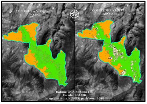
Based on the radiometric, geometric and atmospheric correction of the 1991 Landsat 5 satellite images and their subsequent supervised classification with the maximum likelihood algorithm, the land use map is generated, resulting in five land uses and coverage (moor, crop, forest, grassland and water bodies) with the following quantitative land use values: moor zone 4 146.06 ha representing 35.28 %, crops 1 990.17 ha 16.93 %, forest 4 332.89 ha with 36.87 %, grassland 1 251.83 ha 10.65 %, water bodies 32.40 ha with 0.28 %, with a total study area of 11 753.35 ha.
The analysis of vegetation cover in 2016 resulted in the same five land uses and coverage as in the 1991 analysis quantitatively the following land use values: moor zone 3 431.14 ha representing 29.19 %, crops 3 200.53 ha 27.23 %, forest 2 355.95 ha with 20.04 %, grassland 2 735.53 ha 23.27 %, water bodies 30.20 ha with 0.26 %, with a total study area of 11 753.35 ha.
Land cover change
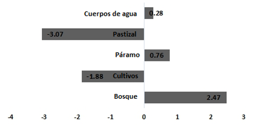
Figure 4, shows the changes in land use of the study area, in 1991 the forested area had an area of 4 332.89 ha however, by 2016 this decreased to 1 976.94 ha with a deforestation rate of 2.47 %, similarly the moor area had an area of 4 146,06 ha reducing by 2016 by 714 ha with a loss rate of 0.76 % the water bodies had an area of 32.4 ha which decreased by 2.2 ha thus the rate of change was 0.28 %, meanwhile for grasslands the initial area was 1 251.83 ha which increased by 3.07 %, likewise the crop area was recorded 1 990.17 ha increased by 1.88 % (Figure 4).
For the analysis of land use change patterns, an evolution matrix was generated in terms of surface area and percentage, which clearly explains the changes that occurred in each category over a 25 year period (Table 1).
Between 1991 and 2016, 1 976.94 ha of forest areas, 714.92 ha of moor, 2.2 ha of water bodies have been lost (Table 1), therefore, it is represented with negative values indicating that these three categories were gradually losing area in 25 years.
Meanwhile, 1,210.36 ha belonging to crops and 1,483.7 ha of grassland represent sites that, presumably, could have contributed to the advance of the agricultural border while grassland areas have been increasing due to the implementation of cattle-raising.
It is possible to speculate that, due to the above-mentioned causes, this forest area has been fragmented and degraded over the past 25 years, in addition to the slash-and-burn activities carried out by the site's inhabitants, causing a loss not only of plant species but also of the forest's diversity, despite the fact that it is located within a protected area.
Table 1. - Evolution of land use in area and percentage between 1991 and 2016
| N° | Categories | 1991 (ha) | % | 2016 (ha) | % | Change in surface area (ha) |
| 1 | forest | 4 332,89 | 36,87 | 2 355,95 | 20,04 | -1 976,94 |
| 2 | cultivation | 1 990,17 | 16,93 | 3 200,53 | 27,23 | 1210,36 |
| 3 | moorland | 4 146,06 | 35,28 | 3 431,14 | 29,19 | -714,92 |
| 4 | grassland | 1 251,83 | 10,65 | 2 735,53 | 23,27 | 1 483,70 |
| 5 | body of water | 32,40 | 0,28 | 30,20 | 0,26 | -2,20 |
| Total | 11 753,35 | 100 | 11 753,35 | 100 |
The dynamics of land use change are presented in Table 2.
The sum of the persistence values (indicated on the diagonal) establishes that a total of 9,059.29 ha maintained their occupancy category, which represents 77.08% of the total forest area of the Guangras community.
The results of gains and losses indicate notable losses of 1 689.65 ha of forest and a tiny gain of just 0.35 ha, crops had a loss of 2.3 ha and a gain of 1 403.44 ha, moorland loss was 788.67 ha with a gain of 3.35 ha, grasslands had 213.24 ha of loss and 1 286.92 ha of gain, and water bodies lost 0.2 ha with a gain of zero (Table 2).
Table 2. - Transition matrix by cross-tabulation of 1991 and 2016 land uses
| Stable (9059.29) | forest | cultivation | wasteland | grasssland | body of water | Total (1991) | Losses | Total change |
| bosque | 2 355,95 | 723,14 | 0,36 | 966,15 | 0 | 4 045,60 | 1 689,65 | 1 690,00 |
| cultivo | 0 | 1 990,17 | 2,30 | 0 | 0 | 1 992,47 | 2,30 | 1 405,74 |
| páramo | 0 | 468,10 | 3 431,14 | 320,57 | 0 | 4 219,81 | 788,67 | 792,02 |
| pastizal | 0,35 | 212,20 | 0,69 | 1 251,83 | 0 | 1 465,07 | 213,24 | 1 500,16 |
| cuerpos de agua | 0 | 0 | 0 | 0,20 | 30,20 | 30,40 | 0,20 | 0,20 |
| Total (2016) | 2 356,30 | 3 393,61 | 3 434,49 | 2 538,75 | 30,20 | 11 753,35 | ||
| Ganancias | 0,35 | 1 403,44 | 3,35 | 1 286,92 | 0 |
The result of the present study provides a characterization of land use change in the Santiago River micro-watershed during the period 1991-2016, by using the maximum likelihood procedure (Figure 5).

The most representative changes in surface area are the forest, which has lost 16.83 %, while crops increased by 10.3 %, while the moor zone has lost 6.09 %; however, the grassland zone increased in area by 12.62 %, and water bodies decreased by 0.02 %.
Between 1991 and 2016, more than 2 694.35 ha of natural vegetation were lost. The situation is especially critical in the case of forests, which contribute 36.87 % of the total area. Land dedicated to livestock (pasture) increased its area by 1 483.7 ha due to the expansion of agricultural areas and livestock.
DISCUSSION
The evaluation of thematic reliability in the five land uses: forest, crop, moor, grassland, pasture, water body, is in agreement with those obtained by (Champo, Valderrama and Spain 2012; Pimiento 2019; Camacho, Jara and González, 2022).
In relation to land use changes, we agree with Damian et al., (2018) in the Jubal River micro-watershed (MCJ), Southwest of Sangay National Park, Achupallas parish, Alausí canton, Chimborazo province, where the analysis of land cover and land use changes showed in from 1991 to 2011 there was a decrease in the moor area and an increase in crop and pasture areas results attributed to an increase in livestock and agricultural production. In fact, these are the most important livelihood activities in the eastern part of the micro-watershed.
It also coincides with the results reported by Cargua et al., (2018) in Ceja Andina forest in the southwest of the PNS where there was from 2001 to 2014 forest decrease of 18 888.72 ha, with a loss of 1 931.60 ha as a consequence according to forest harvesting to then use the land for agriculture.
The land use changes occurring in the area according to Vistin (2018) are as a consequence of the indigenous communities changing their economy, carrying out activities such as cattle ranching, cultivation of Solanum quitoense Lam and timber exploitation through inadequate practices deteriorating the natural resources and the environment of the interior and buffer zone of the SNP.
Most of the communities in the park's highlands are traditionally settled Quichua Indians who have obtained their lands through the recognition of communal territories by the extinct Ecuadorian Institute of Agrarian Reform and Colonization (Instituto Ecuatoriano de Reforma Agraria y Colonización). The time of settlement, the available land and the pressures of the internal market are the reasons why their main form of work has been the clearing of the forest, extending the agricultural frontier through the introduction of crops and livestock.
Farmer communities are oriented towards basic subsistence production combined with a few crops for commercialization in the domestic market. These communities have also been displaced to lands unsuitable for agricultural and livestock uses, resulting in a progressive depletion of the resource that substantially reduces yields and triggers erosion processes, which goes against the park's conservationist goals. Grazing is an activity that has intensified in the last decade, especially in the moorlands. Because of the climatic conditions and especially because of the frequent frosts, agriculture is not practiced at altitudes of 3,400 m. This is why all the families are dedicated to grazing. For this reason, all the families are dedicated to livestock farming, mainly sheep (Gómez et al., 1998).
Downer (1996) states that from 1991-1993 in the Culebrillas sector (including areas inside the park) there were among 300 to 1,000 head of cattle, which cause several problems, including soil erosion. The dynamics of change is also triggered and controlled by demographic factors and the resulting productive activities; most of the population living in the park's surrounding areas has agricultural activities as their main occupation: 33.9 % in Pondoa, 50 % of the men in Osogoche, 43.6 % in San Vicente and 54 % in Colonia Tarqui. Although women are considered to be dedicated to domestic chores, there are references that women also contribute to and participate in agricultural work and animal grazing (Gómez et al., 1998).
The conservation status of the forest resource presents fragments of natural habitat, under strong pressure as a result of anthropogenic factors (MARENA, 2004). Fragmentation of the native forest occurs due to the replacement of large areas by other ecosystems, leaving patches (or islands) separated from the forest and from each other Dzieszko (2014). In the area this is evident in the different sizes and shapes of the fragments that reflect the different landscape coverage. The degree of intervention in the area results in excessive fragmentation of the forest.
Human modifications are the most determinant in the fragmentation of ecosystems, accelerating habitat loss and the reduction of biological diversity. The change from native forest to grassland and agricultural areas in the area makes the landscape more fragmented and the edge effect more abrupt (Ruiz, Savé and Herrera 2013).
The results corroborate estimates on the proportion of areas of certain coverage and their changes, exposed in other research works within the micro-watershed of the Blanco River, Cayambe, Ecuador, such as the work of Valencia (2014), who determined that 19 % of the forest has been converted to pasture, while in this study the result was 20.04 %. There was also coincidence with the results of Lozano, Delgado and Aguirre (2003), who determined that the main causes of deforestation in Bosques Montanos, located in the Podocarpus National Park have been caused by the growth of agricultural activities at the expense of the existing vegetation cover.
This also coincides with the loss of vegetation cover in other spatiotemporal studies such as those reported by Nájera et al., (2010) in 1995 and 2005 in the state of Nayarit, Mexico, by Hernández et al., (2015) from 1995 and 2008 on the coast of Tabasco, Mexico, by Fragoso (2017) from 2003 to 2014 in the municipality Acaxochitlán, in the state of Hidalgo, Mexico, Sepúlveda, Saavedra and Esse (2019) in a hydrographic sub-basin, in the region of La Araucanía, Chile, from 1994-2007, as well as in protected areas such as those reported by Ruiz, Save and Herrera (2014) in the Protected Landscape Miraflor Moropotente, Nicaragua from 1993-2011.
CONCLUSIONS
Land use and land cover in the Santiago micro-basin changed considerably from 1991 to 2016, forest, moorland, and water bodies exhibited a reduction in area due to anthropogenic activity of 2.47 %, 0.76 %, 0.28 % respectively. The main driving force of use and cover changes in the Santiago River micro-watershed are cattle ranching and agriculture. The results of this work are useful for future land management plans and in the planning of strategies for the conservation of natural resources in the Santiago River micro-watershed belonging to Sangay National Park.
REFERENCIAS BIBLIOGRÁFICAS
ALEXAKIS, D.D., AGAPIOU, A., HADJIMITSIS, D.G. y RETALIS, A., 2012. Optimizing statistical classification accuracy of satellite remotely sensed imagery for supporting fast flood hydrological analysis. Acta Geophysica [en línea], vol. 60, no. 3, pp. 959-984. [Consulta: 03/02/2022]. ISSN 1895-7455. DOI 10.2478/s11600-012-0025-9. Disponible en: Disponible en: https://doi.org/10.2478/s11600-012-0025-9 . [ Links ]
BERLANGA ROBLES, C.A., GARCÍA CAMPOS, R.R., LÓPEZ BLANCO, J. y RUIZ LUNA, A., 2010. Patrones de cambio de coberturas y usos del suelo en la región costa norte de Nayarit (1973-2000). Investigaciones geográficas [en línea], no. 72, pp. 7-22. [Consulta: 03/02/2022]. ISSN 0188-4611. Disponible en: Disponible en: http://www.scielo.org.mx/scielo.php?script=sci_abstract&pid=S0188-46112010000200002&lng=es&nrm=iso&tlng=es . [ Links ]
BONILLA-MOHENO, M., AIDE, T.M. y CLARK, M.L., 2012. The influence of socioeconomic, environmental, and demographic factors on municipality-scale land-cover change in Mexico. Regional Environmental Change [en línea], vol. 12, no. 3, pp. 543-557. [Consulta: 03/02/2022]. ISSN 1436-378X. DOI 10.1007/s10113-011-0268-z. Disponible en: Disponible en: https://doi.org/10.1007/s10113-011-0268-z . [ Links ]
CAMACHO-LÓPEZ, C.O., JARA-FRANCO, N.E. y GONZÁLEZ-RIVADENEIRA, J.L., 2022. Análisis multitemporal de la deforestación y cambio de la cobertura del suelo en Morona Santiago. Polo del Conocimiento [en línea], vol. 7, no. 1, pp. 797. [Consulta: 03/02/2022]. ISSN 2550-682X. DOI 10.23857/pc.v7i1.3511. Disponible en: Disponible en: https://polodelconocimiento.com/ojs/index.php/es/article/view/3511 . [ Links ]
ESCOBAR FLORES, ROSA ELENA y CASTILLO SANTIAGO, MIGUEL ÁNGEL. 2021. Cambios en la cobertura y uso del suelo en la región del Soconusco, Chiapas. Revista mexicana de ciencias forestales [en línea], 2021. vol. 12, no. 66, pp. 46-69. [Consulta: 03/02/2022]. ISSN 2007-1132. DOI 10.29298/rmcf.v12i66.755. Disponible en: Disponible en: http://www.scielo.org.mx/scielo.php?script=sci_abstract&pid=S2007-11322021000400046&lng=es&tlng=es&nrm=iso . [ Links ]
CARGUA, F.E., RODRÍGUEZ, M.V., ROMERO, B. y SANTILLÁN, P., 2018. Evaluación del estado de conservación del bosque de ceja andina sur occidental del Parque Nacional Sangay (Ecuador), para una mejor gestión del recurso forestal. Revista espacios [en línea], vol. 39, no. 45, pp. 29-41. [Consulta: 03/02/2022]. Disponible en: Disponible en: https://www.semanticscholar.org/paper/Evaluaci%C3%B3n-del-estado-de-conservaci%C3%B3n-del-bosque-de-Cargua-Rodr%C3%ADguez/4fb4e936b2df5787adfeececde3045a456fce2ef . [ Links ]
CHAMPO-JIMÉNEZ, O., VALDERRAMA-LANDEROS, L. y ESPAÑA-BOQUERA, M.L., 2012. Pérdida de cobertura forestal en la reserva de la biosfera Mariposa Monarca, Michoacán, México (2006-2010). Revista Chapingo serie ciencias forestales y del ambiente [en línea], vol. 18, no. 2, pp. 143-157. [Consulta: 03/02/2022]. ISSN 2007-4018. DOI 10.5154/r.rchscfa.2010.09.074. Disponible en: Disponible en: http://www.scielo.org.mx/scielo.php?script=sci_abstract&pid=S2007-40182012000200002&lng=es&nrm=iso&tlng=es . [ Links ]
CHAVEZ, J., 1996. Image-Based Atmospheric Corrections - Revisited and Improved. Photogrammetric Engineering and Remote Sensing [en línea], vol. 62, pp. 1025-1036. Disponible en: https://www.researchgate.net/publication/236769129_Image-Based_Atmospheric_Corrections_-_Revisited_and_Improved. [ Links ]
DAMIAN, D.A., MÁRQUEZ, C.O., GARCÍA, V.J., RODRÍGUEZ, M.V. y RECALDE, C.G., 2018. Transiciones sistemáticas en el uso y la cobertura del suelo en una microcuenca alto andina, Ecuador 1991-2011. Revista Espacios [en línea], vol. 39, no. 32. [Consulta: 03/02/2022]. Disponible en: https://www.semanticscholar.org/paper/Transiciones-sistem%C3%A1ticas-en-el-uso-y-la-cobertura-Damian-M%C3%A1rquez/bd57211ce31ee6a9c848e4da9739e2b1beb6a0bf . [ Links ]
DZIESZKO, P., 2014. Land-cover modelling using corine land cover data and multi-layer perceptron. Quaestiones Geographicae [en línea], vol. 33, no. 1. DOI 10.2478/quageo-2014-0004. Disponible en: https://www.researchgate.net/publication/272537119_Land-cover_modelling_using_corine_land_cover_data_and_multi-layer_perceptron. [ Links ]
LOZANO, P., DELGADO, T. y AGUIRRE, Z., 2003. Estado actual de la flora endémica exclusiva y su distribución en el occidente del Parque Nacional Podocarpus [en línea]. Loja: Fundación ecuatoriana para la Investigación y Desarrollo de la Botánica. ISBN 978-9978-09-027-5. Disponible en: http://biblioteca.udet.edu.ec/cgi-bin/koha/opac-detail.pl?biblionumber=1130&shelfbrowse_itemnumber=1266.581.9866/L925 [ Links ]
MARENA, 2004. Plan De Manejo Del Paisaje Terrestre Protegido Miraflor Moropotente. Ministerio de Ambiente y Recursos Naturales. Managua. 2004. S.l.: MARENA. [ Links ]
NÁJERA-GONZÁLEZ, O., BOJÓRQUEZ-SERRANO, J.I., CIFUENTES-LEMUS, J.L. y MARCELEÑO-FLORES, S., 2010. Cambio de cobertura y uso del suelo en la cuenca del río Mololoa, Nayarit. Revista Bio Ciencias [en línea], vol. 1, no. 1. [Consulta: 03/02/2022]. ISSN 2007-3380. DOI 10.15741/revbio.01.01.03. Disponible en: Disponible en: http://revista.uan.mx/index.php/BIOCIENCIAS/article/view/8 . [ Links ]
ORTEGA, J.G., ÁLVAREZ, V. y RIVADENEIRA, D., 1998. Plan de manejo estratégico del Parque Nacional Sangay [en línea]. S.l.: Ecuador. Dirección Nacional de Areas Naturales y Vida Silvestre, Instituto Ecuatoriano Forestal y de Areas Naturales y Vida Silvestre. Disponible en: https://books.google.com.cu/books/about/Plan_de_manejo_estrat%C3%A9gico_del_Parque_N.html?id=1qvOPgAACAAJ&redir_esc=y. [ Links ]
PÉREZ HERNÁNDEZ, M.J., HERNÁNDEZ ACOSTA, E., SÁNCHEZ JIMÉNEZ, R., GONZÁLEZ GERVACIO, C., MADRIGAL REYES, S., PÉREZ HERNÁNDEZ, M.J., HERNÁNDEZ ACOSTA, E., SÁNCHEZ JIMÉNEZ, R., GONZÁLEZ GERVACIO, C. y MADRIGAL REYES, S., 2021. Dinámica de cambios de uso de suelo y vegetación por actividades antropogénicas en Zaachila, Oaxaca. Revista mexicana de ciencias forestales [en línea], vol. 12, no. 66, pp. 26-45. [Consulta: 03/02/2022]. ISSN 2007-1132. DOI 10.29298/rmcf.v12i66.894. Disponible en: http://www.scielo.org.mx/scielo.php?script=sci_abstract&pid=S2007-11322021000400026&lng=es&nrm=iso&tlng=es . [ Links ]
RUIZ, V., SAVÉ, R. y HERRERA, A., 2013. Análisis multitemporal del cambio de uso del suelo, en el Paisaje Terrestre Protegido Miraflor Moropotente Nicaragua, 1993-2011. En: Accepted: 2014-01-10T11:07:50Z, Revista Científica de FAREM-Estelí. Medio ambiente, tecnología y desarrollo humano [en línea], vol. 11, no. 3. [Consulta: 03/ 02/2022]. ISSN 1697-2473. DOI 10.7818/ECOS.2013.22-3.16. Disponible en: Disponible en: http://rua.ua.es/dspace/handle/10045/34856 . [ Links ]
SANDOVAL-GARCÍA, R., GONZÁLEZ CUBAS, R., JIMÉNEZ PÉREZ, J., SANDOVAL-GARCÍA, R., GONZÁLEZ CUBAS, R. y JIMÉNEZ PÉREZ, J., 2021. Análisis multitemporal del cambio en la cobertura del suelo en la Mixteca Alta Oaxaqueña. Revista mexicana de ciencias forestales [en línea], vol. 12, no. 66, pp. 96-121. [Consulta: 03/02/2022]. ISSN 2007-1132. DOI 10.29298/rmcf.v12i66.816. Disponible en: Disponible en: http://www.scielo.org.mx/scielo.php?script=sci_abstract&pid=S2007-11322021000400096&lng=es&nrm=iso&tlng=es . [ Links ]
SEPÚLVEDA-VARAS, A., SAAVEDRA-BRIONES, P., ESSE, C., SEPÚLVEDA-VARAS, A., SAAVEDRA-BRIONES, P. y ESSE, C., 2019. Análisis de cambio de cobertura y uso de suelo en una subcuenca preandina chilena. Herramienta para la sustentabilidad productiva de un territorio. Revista de geografía Norte Grande [en línea], no. 72, pp. 9-25. [Consulta: 03/02/2022]. ISSN 0718-3402. DOI 10.4067/S0718-34022019000100009. Disponible enDisponible en: http://www.scielo.cl/scielo.php?script=sci_abstract&pid=S0718-34022019000100009&lng=es&nrm=iso&tlng=es . [ Links ]
Received: July 03, 2021; Accepted: February 02, 2022
 Este es un artículo publicado en acceso abierto bajo una licencia Creative Commons
