<?xml version="1.0" encoding="ISO-8859-1"?><article xmlns:mml="http://www.w3.org/1998/Math/MathML" xmlns:xlink="http://www.w3.org/1999/xlink" xmlns:xsi="http://www.w3.org/2001/XMLSchema-instance">
<front>
<journal-meta>
<journal-id>1993-8012</journal-id>
<journal-title><![CDATA[Minería y Geología]]></journal-title>
<abbrev-journal-title><![CDATA[Min. Geol.]]></abbrev-journal-title>
<issn>1993-8012</issn>
<publisher>
<publisher-name><![CDATA[EDUM. Universidad de Moa]]></publisher-name>
</publisher>
</journal-meta>
<article-meta>
<article-id>S1993-80122017000200008</article-id>
<title-group>
<article-title xml:lang="en"><![CDATA[Metal accumulation in surface sediment of the urban and industrial coastal area of the municipality of Moa (Cuba): distribution and pollution assessment]]></article-title>
<article-title xml:lang="es"><![CDATA[Acumulación de metales en sedimentos superficiales de la zona costera urbana e industrial del municipio de Moa (Cuba): distribución y evaluación de la contaminación]]></article-title>
</title-group>
<contrib-group>
<contrib contrib-type="author">
<name>
<surname><![CDATA[Cervantes Guerra]]></surname>
<given-names><![CDATA[Yosbanis]]></given-names>
</name>
<xref ref-type="aff" rid="A01"/>
</contrib>
<contrib contrib-type="author">
<name>
<surname><![CDATA[Pierra Conde]]></surname>
<given-names><![CDATA[Allan]]></given-names>
</name>
<xref ref-type="aff" rid="A02"/>
</contrib>
<contrib contrib-type="author">
<name>
<surname><![CDATA[Rodríguez Infante]]></surname>
<given-names><![CDATA[Alina]]></given-names>
</name>
<xref ref-type="aff" rid="A01"/>
</contrib>
<contrib contrib-type="author">
<name>
<surname><![CDATA[Almaguer Carmenates]]></surname>
<given-names><![CDATA[Yuri]]></given-names>
</name>
<xref ref-type="aff" rid="A03"/>
</contrib>
<contrib contrib-type="author">
<name>
<surname><![CDATA[Jürgen Gursky]]></surname>
<given-names><![CDATA[Hans]]></given-names>
</name>
<xref ref-type="aff" rid="A04"/>
</contrib>
<contrib contrib-type="author">
<name>
<surname><![CDATA[Van Caneghem]]></surname>
<given-names><![CDATA[Jo]]></given-names>
</name>
<xref ref-type="aff" rid="A05"/>
</contrib>
<contrib contrib-type="author">
<name>
<surname><![CDATA[Vandecasteele]]></surname>
<given-names><![CDATA[Carlo]]></given-names>
</name>
<xref ref-type="aff" rid="A05"/>
</contrib>
</contrib-group>
<aff id="A01">
<institution><![CDATA[,Mining and Metallurgist Institute of Moa  ]]></institution>
<addr-line><![CDATA[ Holguin]]></addr-line>
<country>Cuba</country>
</aff>
<aff id="A02">
<institution><![CDATA[,University of Computer Science  ]]></institution>
<addr-line><![CDATA[ La Habana]]></addr-line>
<country>Cuba</country>
</aff>
<aff id="A03">
<institution><![CDATA[,Autonomous University of Coahuila  ]]></institution>
<addr-line><![CDATA[ ]]></addr-line>
<country>Mexico</country>
</aff>
<aff id="A04">
<institution><![CDATA[,Technical University of Clausthal  ]]></institution>
<addr-line><![CDATA[ ]]></addr-line>
<country>Germany</country>
</aff>
<aff id="A05">
<institution><![CDATA[,Catholic University of Leuven  ]]></institution>
<addr-line><![CDATA[ ]]></addr-line>
<country>Belgium</country>
</aff>
<pub-date pub-type="pub">
<day>00</day>
<month>06</month>
<year>2017</year>
</pub-date>
<pub-date pub-type="epub">
<day>00</day>
<month>06</month>
<year>2017</year>
</pub-date>
<volume>33</volume>
<numero>2</numero>
<fpage>235</fpage>
<lpage>250</lpage>
<copyright-statement/>
<copyright-year/>
<self-uri xlink:href="http://scielo.sld.cu/scielo.php?script=sci_arttext&amp;pid=S1993-80122017000200008&amp;lng=en&amp;nrm=iso"></self-uri><self-uri xlink:href="http://scielo.sld.cu/scielo.php?script=sci_abstract&amp;pid=S1993-80122017000200008&amp;lng=en&amp;nrm=iso"></self-uri><self-uri xlink:href="http://scielo.sld.cu/scielo.php?script=sci_pdf&amp;pid=S1993-80122017000200008&amp;lng=en&amp;nrm=iso"></self-uri><abstract abstract-type="short" xml:lang="en"><p><![CDATA[The investigation is to evaluate the accumulation of ten elements (Al, Cr, Fe, Mn, Ni, Co, As, Cu, Pb and Zn) in surface sediments from the urban and industrial coastal area of Moa. Human activity has influenced the region, which has been developing in one of the most important mining regions of Cuba since the middle of the past century. Two methods were used to assess the contamination of the sediments: the estimation of metal enrichment by calculating the index of geo-accumulation (Igeo) and the interpretation of the data obtained based on quality criteria. The overall range of concentrations is 15,7 - 83,5 mg g-1 for aluminum, 1,4 - 17,9 mg g-1 for chromium, 22,8 - 379,5 mg g-1 for iron, 1,5 - 56,2 mg g-1 for manganese, 0,9 - 6,2 mg g-1 for nickel, 56 - 1094 µg g-1 for cobalt, 6 - 126 µg g-1 for arsenic, 17 to 146 µg g-1 for copper, 6 - 66 µg g-1 for lead, and 64 - 576 µg g-1 for zinc. The results obtained from the studied coastal zone show a high level of pollution in surface sediments. The spatial distribution of the elements varied according to the analyzed elements: Al, Cr, Fe and Ni showed high levels of concentration throughout the studied zone; Mn, Co, Cu, As and Zn are in a higher proportion in Moa Bay Cay. In the case of As and Pb, higher concentrations were located at the deltas of Moa and Cayo Guam rivers and also in some areas in the west of the bay.]]></p></abstract>
<abstract abstract-type="short" xml:lang="es"><p><![CDATA[La investigación consiste en evaluar la acumulación de diez elementos (Al, Cr, Fe, Mn, Ni, Co, As, Cu, Pb y Zn) en los sedimentos superficiales de la zona costera urbana e industrial de Moa. La actividad humana ha influido en la región, que se está desarrollando en una de las zonas mineras más importantes de Cuba desde mediados del siglo pasado. Se utilizaron dos métodos para evaluar la contaminación de los sedimentos: la estimación del enriquecimiento de metales mediante el cálculo del índice de geoacumulación (Igeo) y la interpretación de los datos obtenidos en base a criterios de calidad. El rango general de concentraciones es de 15,7-83,5 mg g-1 para el aluminio, 1,4-17,9 mg g-1 para el cromo, 22,8-379,5 mg g-1 para el hierro, 1,5-56,2 mg g-1 para el manganeso, 0,9-6,2 mg g-1 para el níquel, 56-1 094 &#956;g g-1 para el cobalto, 6-126 &#956;g g-1 para el arsénico, 17 a 146 &#956;g g-1 para el cobre, 6-66 &#956;g g-1 para el plomo y 64-576 &#956;g g-1 para el zinc. Los resultados obtenidos de la zona costera estudiada muestran un alto nivel de contaminación en los sedimentos superficiales. La distribución espacial de los elementos varió según los elementos analizados: Al, Cr, Fe y Ni mostraron altos niveles de concentración en toda la zona estudiada; Mn, Co, Cu, As y Zn están en una proporción más alta en Bahía de Cayo Moa. En el caso de As y Pb, las concentraciones más altas se localizaron en los deltas de los ríos Moa y Cayo Guam y también en algunas áreas en el oeste de la bahía.]]></p></abstract>
<kwd-group>
<kwd lng="en"><![CDATA[Moa Bay Cay]]></kwd>
<kwd lng="en"><![CDATA[geoaccumulation index]]></kwd>
<kwd lng="en"><![CDATA[contamination in marine sediments]]></kwd>
<kwd lng="en"><![CDATA[mining impacts]]></kwd>
<kwd lng="en"><![CDATA[geoenvironmental study]]></kwd>
<kwd lng="es"><![CDATA[Bahía de Cayo Moa]]></kwd>
<kwd lng="es"><![CDATA[índice de geoacumulación]]></kwd>
<kwd lng="es"><![CDATA[contaminación en sedimentos marinos]]></kwd>
<kwd lng="es"><![CDATA[impactos mineros]]></kwd>
<kwd lng="es"><![CDATA[estudio geoambiental]]></kwd>
</kwd-group>
</article-meta>
</front><body><![CDATA[  	    <p align="right"><font face="verdana" size="2"><b>ART&Iacute;CULO ORIGINAL</b></font></p> 	    <p align="right">&nbsp;</p> 	    <p align="right">&nbsp;</p> 	    <p align="left"><font face="verdana" size="4"><b>Metal accumulation in surface sediment of the urban and industrial coastal area of the municipality of Moa (Cuba): distribution and pollution assessment</b></font></p> 	    <p align="left">&nbsp;</p> 	    <p align="left">&nbsp;</p> 	    <p align="left"><b><font face="verdana" size="3">Acumulaci&oacute;n de metales en sedimentos superficiales de la zona costera urbana e industrial del municipio de Moa (Cuba): distribuci&oacute;n y evaluaci&oacute;n de la contaminaci&oacute;n</font></b><font face="verdana" size="2"></font></p> 	    <p align="left">&nbsp;</p> 	    <p align="left">&nbsp;</p>     ]]></body>
<body><![CDATA[<p align="left">&nbsp;</p>  	    <p align="left"><font face="verdana" size="2"><b>Yosbanis Cervantes Guerra</b><sup>1</sup>, <b>Allan Pierra Conde</b><sup>2</sup>, <b>Alina Rodr&iacute;guez Infante</b><sup>1</sup>,</font> <font face="verdana" size="2"><b>Yuri Almaguer Carmenates</b><sup>3,</sup> <b>Hans J&uuml;rgen Gursky</b><sup>4</sup>, <b>Jo Van Caneghem</b><sup>5</sup>,</font> <font face="verdana" size="2"><b>Carlo Vandecasteele</b><sup>5</sup></font></p>  	    <p align="left"><font face="verdana" size="2">&nbsp;</font></p>  	    <p><font face="verdana" size="2"><sup>1</sup>Mining and Metallurgist Institute of Moa, Holguin, Cuba <a href="mailto:ycervantes@ismm.edu.cu">ycervantes@ismm.edu.cu     <br> 	</a><sup>2</sup>University of Computer Science, La Habana, Cuba <a href="mailto:apierra@mes.gob.cu">apierra@mes.gob.cu</a></font>    <br> 	<font face="verdana" size="2"><sup>3</sup>Autonomous University of Coahuila, Mexico <a href="mailto:yalmaguer97@gmail.com">yalmaguer97@gmail.com</a></font>    <br> 	<font face="verdana" size="2"><sup>4</sup>Technical University of Clausthal, Germany <a href="mailto:gursky@geologie.tu&#45;clausthal.de">gursky@geologie.tu&#45;clausthal.de</a></font>    <br> 	<font face="verdana" size="2"><sup>5</sup>Catholic University of Leuven, Belgium <a href="mailto:jo%20vancaneghem@kuleuven.be">jo vancaneghem@kuleuven.be</a></font>    <br> 	</p> 	    <p>&nbsp;</p> 	    ]]></body>
<body><![CDATA[<p>&nbsp;</p>     <hr> 	    <p><font face="verdana" size="2"><b>RESUMEN</b></font></p>  	    <p align="justify"><font face="verdana" size="2">The investigation is to evaluate the accumulation of ten elements (Al, Cr, Fe, Mn, Ni, Co, As, Cu, Pb and Zn) in surface sediments from the urban and industrial coastal area of Moa. Human activity has influenced the region, which has been developing in one of the most important mining regions of Cuba since the middle of the past century. Two methods were used to assess the contamination of the sediments: the estimation of metal enrichment by calculating the index of geo&#45;accumulation (Igeo) and the interpretation of the data obtained based on quality criteria. The overall range of concentrations is 15,7 &#150; 83,5 mg g<sup>&#45;1</sup> for aluminum, 1,4 &#150; 17,9 mg g<sup>&#45;1</sup> for chromium, 22,8 &#150; 379,5 mg g<sup>&#45;1</sup> for iron, 1,5 &#150; 56,2 mg g<sup>&#45;1</sup> for manganese, 0,9 &#150; 6,2 mg g<sup>&#45;1</sup> for nickel, 56 &#45; 1094 &#181;g g<sup>&#45;1</sup> for cobalt, 6 &#45; 126 &#181;g g<sup>&#45;1</sup> for arsenic, 17 to 146 &#181;g g<sup>&#45;1</sup> for copper, 6 &#45; 66 &#181;g g<sup>&#45;1</sup> for lead, and &nbsp;64 &#45; 576 &#181;g g<sup>&#45;1</sup> for zinc. The results obtained from the studied coastal zone show a high level of pollution in surface sediments. The spatial distribution of the elements varied according to the analyzed elements: Al, Cr, Fe and Ni showed high levels of concentration throughout the studied zone; Mn, Co, Cu, As and Zn are in a higher proportion in Moa Bay Cay. In the case of As and Pb, higher concentrations were located at the deltas of Moa and Cayo Guam rivers and also in some areas in the west of the bay.</font></p>  	    <p align="justify"><b><font face="verdana" size="2">Palabras clave</font></b><font face="verdana" size="2">: Moa Bay Cay; geoaccumulation index; contamination in marine sediments; mining impacts; geoenvironmental study.</font></p>     <p align="justify">&nbsp;</p>     <hr>  	    <p align="justify"><b>ABSTRACT</b></p>  	    <p align="justify"><font face="verdana" size="2">La investigaci&oacute;n consiste en evaluar la acumulaci&oacute;n de diez elementos (Al, Cr, Fe, Mn, Ni, Co, As, Cu, Pb y Zn) en los sedimentos superficiales de la zona costera urbana e industrial de Moa. La actividad humana ha influido en la regi&oacute;n, que se est&aacute; desarrollando en una de las zonas mineras m&aacute;s importantes de Cuba desde mediados del siglo pasado. Se utilizaron dos m&eacute;todos para evaluar la contaminaci&oacute;n de los sedimentos: la estimaci&oacute;n del enriquecimiento de metales mediante el c&aacute;lculo del &iacute;ndice de geoacumulaci&oacute;n (Igeo) y la interpretaci&oacute;n de los datos obtenidos en base a criterios de calidad. El rango general de concentraciones es de 15,7&#45;83,5 mg g<sup>&#45;1</sup> para el aluminio, 1,4&#45;17,9 mg g<sup>&#45;1</sup> para el cromo, 22,8&#45;379,5 mg g<sup>&#45;1</sup> para el hierro, 1,5&#45;56,2 mg g<sup>&#45;1</sup> para el manganeso, 0,9&#45;6,2 mg g<sup>&#45;1</sup> para el n&iacute;quel, 56&#150;1 094 &#956;g g<sup>&#45;1</sup> para el cobalto, 6&#45;126 &#956;g g<sup>&#45;1</sup> para el ars&eacute;nico, 17 a 146 &#956;g g<sup>&#45;1</sup> para el cobre, 6&#45;66 &#956;g g<sup>&#45;1</sup> para el plomo y 64&#45;576 &#956;g g<sup>&#45;1</sup> para el zinc. Los resultados obtenidos de la zona costera estudiada muestran un alto nivel de contaminaci&oacute;n en los sedimentos superficiales. La distribuci&oacute;n espacial de los elementos vari&oacute; seg&uacute;n los elementos analizados: Al, Cr, Fe y Ni mostraron altos niveles de concentraci&oacute;n en toda la zona estudiada; Mn, Co, Cu, As y Zn est&aacute;n en una proporci&oacute;n m&aacute;s alta en Bah&iacute;a de Cayo Moa. En el caso de As y Pb, las concentraciones m&aacute;s altas se localizaron en los deltas de los r&iacute;os Moa y Cayo Guam y tambi&eacute;n en algunas &aacute;reas en el oeste de la bah&iacute;a.</font><font face="verdana" size="2"><b>&nbsp;</b></font></p>  	    <p><font face="verdana" size="2"><b>Keywords: </b>Bah&iacute;a de Cayo Moa; &iacute;ndice de geoacumulaci&oacute;n; contaminaci&oacute;n en sedimentos marinos; impactos mineros; estudio geoambiental.</font></p>  	    <p>&nbsp;</p>  	    <p><b><font face="verdana" size="2">1.&nbsp;INTRODUCTION</font></b></p>  	    ]]></body>
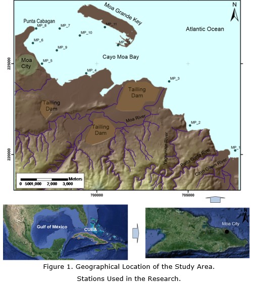
<body><![CDATA[<p align="justify"><font face="verdana" size="2">Studies about toxic elements in surface sediments are considered to be relevant for geochemical investigations on seacoasts as these elements &nbsp;&nbsp;may dissolve and be incorporated in the ecosystem, turning them into environmental risk areas (<a href="#ref17">Zhu <i>et al</i>. 2012</a>; <a href="#ref9">Herrera <i>et al.</i> 2013</a>; <a href="#ref8">Gupta <i>et al</i>. 2014</a>; <a href="#ref7">Gang <i>et al</i>. 2016</a>).</font></p>  	    <p align="justify"><font face="verdana" size="2">The mobility of metals is generally considered very low: they accumulate on the first centimeters of the sediment and only very small quantities reach the subsurface. Therefore, a high concentration on the surface horizon is a good diagnostic criterion for anthropogenic pollution. The coastline of the Moa Bay Cay located to the northeast of the province of Holgu&iacute;n, Cuba has suffered a great deterioration due to mining and metallurgical activities (<a href="#ref3">Cervantes <i>et al</i>. 2011</a>).</font></p>  	    <p align="justify"><font face="verdana" size="2">The municipality of Moa is the most important mining town of Cuba, with an average production of more than 60 thousand tons of nickel and cobalt on a yearly basis (National Bureau of Statistics and Information <a href="#ref14">(ONEI) 2014</a>). Moa with a population of 75 101 inhabitants (<a href="#ref14">ONEI 2014</a>) has two mine &#45; metallurgical plants in operation, one port and an airport.</font></p>  	    <p align="justify"><font face="verdana" size="2">The main impacts produced by mining operations in Moa are the disappearance of extensive areas of forests, the construction of geological exploration trails and of mining roads, and the formation of large deposits of industrial tailings. This has led to increased erosion of the land surface resulting from more than 10<sup>6</sup> m<sup>3</sup>/year of sediments being carried by surface streams and deposited in the Moa Bay Cay (<a href="#ref6">Fern&aacute;ndez 2009</a>).</font></p>  	    <p align="justify"><font face="verdana" size="2">The coast of Moa is 50,1 km long (<a href="#ref14">ONEI 2014</a>), of which 13,9 kms (28 %) were studied. It is bordered on the north by the Atlantic Ocean, on the south by the coastal portion that covers Punta Cabagan to the mouth of the Cayo Guam River. The limits of the land in the coastal area include the city of Moa, the urban settlement of Punta Gorda, the industrial facilities and areas affected by mining operations (<a href="#F1">Figure 1</a>).</font></p>  	    <p align="center"><font face="verdana" size="2"><img src="/img/revistas/mg/v33n2/f0108217.jpg" alt="1" name="F1" id="F1" border="0"></font></p>  	    <p align="justify"><font face="verdana" size="2">The studied area has a substrate formed by serpentinized ultrabasic rocks with a high degree of alteration, which was subjected to an intense tectonic activity. The degree of serpentinization in the region varies. Laterite soils lie on the serpentinized substrate, spatially located along the coast or near. Cr, Fe, Mn, Ni, Co, Cu, and Zn occur in various proportions in different profiles of the laterite soils.</font></p>  	    <p align="justify"><font face="verdana" size="2">At the bottom of the bay, friable quaternary clastic sediments and terrigenous biodentritical prevail. The lithology is represented by four horizons (from the bottom up): calcareous grit, carbonated sandy silt, carbonated silty and terrigenous silt (<a href="ref12">Men&eacute;ndez 2001</a>).</font></p>  	    <p align="justify"><font face="verdana" size="2">The stream pattern in the Moa Bay Cay is ruled by the effect of tides, showing a net water movement in the western direction during high tides and less intense in the east direction during low tides (<a href="#ref12">Men&eacute;ndez 2001</a>). This implies that most waste and movement sediments carried over by the Cayo Guam, Punta Gorda, Yagrumaje and Moa rivers reach the bay and are being deposited along the coast.</font></p>  	    <p><font face="verdana" size="2"><b>2.&nbsp;MATERIALS AND METHODS</b></font></p>  	    ]]></body>
<body><![CDATA[<p align="justify"><font face="verdana" size="2">For geoaccumulation analysis, sediment samples were taken in three periods from 2009 through 2011. Twelve sampling locations were selected. These were sampled on a yearly basis for three consecutive years. Ten elements (Al, Cr, Fe, Mn, Ni, Co, As, Cu, Pb, and Zn) were determined. The average value will be used for subsequent calcullations.</font></p>  	    <p align="justify"><font face="verdana" size="2">Samples were collected by scuba diving. A collector tube inserted into the mud allowed 50 cm of sediment to be extracted. All samples were stored in a plastic bag of about one kilogram capacity.</font></p>  	    <p align="justify"><font face="verdana" size="2">The evaluated area was divided into two areas of work:</font></p>  	    <p align="justify"><font face="verdana" size="2"><i>Deltaic zone</i>: In this zone, the mouth of Moa, Yagrumaje, and Cayo Guam rivers were monitored. These are the main ways through which pollutants get into the marine area; therefore, the pollution of the area is caused by sediments recently accumulated in the delta. MP 1, MP 2 and MP 3 stations were located in the deltaic zone (Figure 1).</font></p>  	    <p align="justify"><font face="verdana" size="2"><i>Industrial and urban, coastal zone:</i> This includes the lagoon of the Moa Bay Cay that is bordered on the south by the coastline of Moa city and on the north by the southern coast of the Moa Grande Cay. It extends from Punta Cabagan in the west to Moa River in the east. Stations MP 5, MP 6, MP 7, MP 8 MP 9 MP 10, MP 11 and MP 12 where located in Moa Bay Cay (Figure 1).</font></p>  	    <p align="justify"><font face="verdana" size="2">The samples were dried at 60 &#176;C for 24 hours and later sieved. The fraction &#706; 63 microns were extracted for analysis. A portion of dry sediment (0.5 g) was digested with the following mix of Suprapur&#174; quality acid: 5 ml of HNO<sub>3</sub> (concentrated), 10 ml of HF (concentrated) and 7 ml of HClO<sub>4</sub> (concentrated) and evaporated to dryness. The residue was dissolved in 10 ml of HCl (concentrated) tranferred to a Teflon flask and adjusted to 25 ml with pure deionized water of 18.2 M&#937;cm<sup>&#45;1</sup>. Determinations were carried out by using a Varian Vista MPX Axial ICP &#45; AES spectrometer.</font></p>  	    <p align="justify"><font face="verdana" size="2">The accuracy of the analytical procedure used was checked by repeatedly analyzing reference samples (IAEA&#45;365), and comparing the obtained values with the expected values. The quality control samples represented 10 % of the total analytical load. Precision was over 50 % and the results for the references samples were between 93 % and 105 % compared to the certified value.</font></p>  	    <p align="justify"><font face="verdana" size="2">The index value of geoaccumulation defined by <a href="#ref13">M&uuml;ller (1969)</a> was used for assessing the contamination caused by sediments. This index has been used in several investigations and is proven to be a useful pollution geoindicator (Amat <i>et al</i>. 2002; <a href="#ref15">Ong <i>et al</i>. 2013</a>), (See Supporting Information SI.I).</font></p>  	    <p align="justify"><font face="verdana" size="2">The limits proposed by <a href="#ref10">Long <i>et al</i>. (1995)</a> were used (See Supporting Information SI.II) in order to interpret the information based on ecotoxicological criteria.</font></p>  	    <p><b><font face="verdana" size="2">3.&nbsp;RESULTS AND DISCUSSIN</font></b></p>  	    ]]></body>
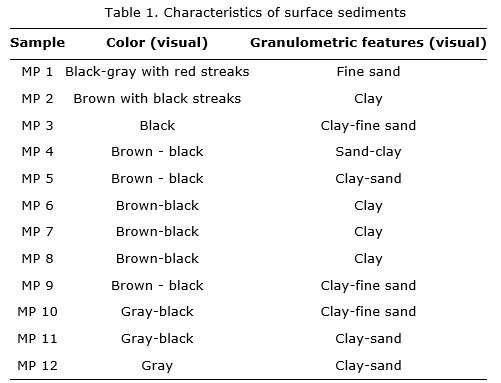
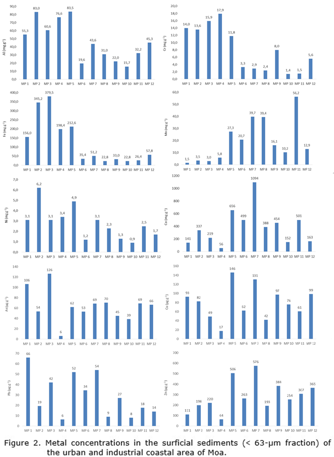
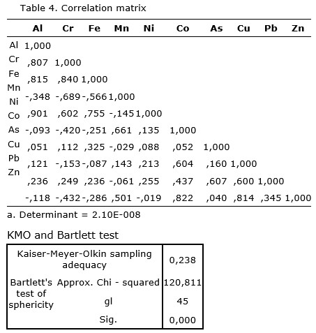
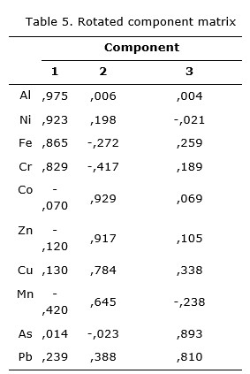
<body><![CDATA[<p align="justify"><b><font face="verdana" size="2">3.1. Sediment characterization</font></b></p>  	    <p align="justify"><font face="verdana" size="2">The color of the sediment obtained in the studied coastal area ranged between black and brown&#45;red. The sediments most affected by suspended materials penetrating into the marine environment through Yagrumaje and Cayo Guam rivers are reddish, which is caused by laterite sediments.</font></p>  	    <p align="justify"><font face="verdana" size="2">However, sediments obtained from the delta of Moa River (MP 3) have a black coloration very similar to the tailings deposited near the mouth of the Moa Rive. This waste is carried over to the coast due to erosion during periods of heavy rains.</font></p>  	    <p align="justify"><font face="verdana" size="2">Granulometry, in most stations, shows the presence of clay or a mixture of clay with different types of sand (<a href="#t1">Table 1</a>).</font></p>  	    <p align="center"><img src="/img/revistas/mg/v33n2/t0108217.jpg" name="t1" id="t1">	</p> 	    <p align="justify"><font face="verdana" size="2">Factor analysis showed that the elements determined are in three groups: there is a high correlation between, Al, Cr, Ni and Fe (first group); a second group shows a high correlation between Mn, Co, Cu and Zn, and finally, a third group is formed by As and Pb (See Supporting Information SI.III).</font></p>  	    <p><b><font face="verdana" size="2">3.2. Distribution of the elements studied</font></b></p>  	    <p><font face="verdana" size="2"><i>Aluminum</i></font></p>  	    <p align="justify"><font face="verdana" size="2">The area with the highest concentrations of Al covers the coastline from the west of Moa (MP 5) to the mouth of Cayo Guam River (MP 1) (Figure 2). At the MP 5 and MP 2 stations, concentrations above 80 mg g<sup>&#45;1</sup> were recorded. MP 5 is located in one of the areas receiving the largest quantities of sediments from the emerged areas and is situated on the southern shore of the Moa Bay Cay. Removal of silty sediments is high in this area, mainly caused by shallowness and the impact of climatic factors as well as dredging activity on the bay.</font></p>  	    <p align="center"><font face="verdana" size="2"><img src="/img/revistas/mg/v33n2/f0208217.png" name="F2" id="F2" border="0"></font></p>  	    ]]></body>
<body><![CDATA[<p align="justify"><font face="verdana" size="2"><a href="#f2">Figure 2</a>. Metal concentrations in the surficial sediments (&#706; 63&#45;&#181;m fraction) of the urban and industrial coastal area of Moa.</font></p>  	    <p align="justify"><font face="verdana" size="2">The delta of Yagrumaje River (MP 2) is an area where large volumes of eroded laterite sediments coming from various affected areas by the mining activity converge. Another reason explaining a high concentration of Al in this location is erosion of soil profiles in the presence of medium and low&#45;grade bauxite in the northernmost section of the river (<a href="#ref2">Bergues 2006</a>). MP 3 and MP 4 are also close to the dumping area of liquid wastes coming from the industry with contents of Al between 4 000 and 5 000 mg /l (<a href="#ref5">Cueto, Rond&oacute;n y Fuentes 2003</a>).</font></p>  	    <p><font face="verdana" size="2"><i>Chromium</i></font></p>  	    <p align="justify"><font face="verdana" size="2">Two zones that show differences in the chromium accumulation can be distinguished. The highest concentrations of Cr (1,18 to 17,9 mg g<sup>&#45;1</sup>) are found in the coastal area from Moa city (MP 5) to the mouth of the river Cayo Guam (MP 1) and lower concentrations (1,4 to 5,6 mg g<sup>&#45;1</sup>) are found to the west of Moa Bay Cay.</font></p>  	    <p align="justify"><font face="verdana" size="2">Chromium is a common element in the soils of the region; and the industrial wastes are another source of Cr going to the coast.</font></p>  	    <p><font face="verdana" size="2"><i>Iron</i></font></p>  	    <p align="justify"><font face="verdana" size="2">The studied region is one of the largest iron reserves around the world. Fe is concentrated in the tailings discharged by the existing mining industries which are stored behind dams located along the coast, for future use. In general, the concentration values are high. The concentrations of Fe exceed 150 mg g<sup>&#45;1</sup> in five stations. Maximum concentration values were found in MP 3 (379,5 mg g<sup>&#45;1</sup>) and MP 2 (345,2 mg g<sup>&#45;1</sup>) stations, located in the deltas of Moa and Yagrumaje rivers.</font></p>  	    <p align="justify"><font face="verdana" size="2">Lower contents were found to the northwest of the area, where the mayority of the monitored stations are located, except for MP 5 (212,6 mg g<sup>&#45;1</sup>) and MP 4 (198,4 mg g<sup>&#45;1</sup>). In the remaining stations, concentrations were all below 150 mg g<sup>&#45;1</sup> (<a href="#f2">Figure 2</a>).</font></p>  	    <p><font face="verdana" size="2"><i>Manganese</i></font></p>  	    <p align="justify"><font face="verdana" size="2">Manganese is a metal associated to laterite soils and it is essentially found as oxides (MnO). In soil profiles, manganese oxides are phase mineral carriers of cobalt and nickel (<a href="#ref16">Rojas, R&oacute;mulo y Orozco 2012</a>). The highest concentration values were found in the industrial and urban coastal areas. The highest value is found in MP 11 (56,2 mg g<sup>&#45;1</sup>). High concentration values of Mn are also found in MP 7 (39,7 mg g<sup>&#45;1</sup>) and MP 8 (39,4 mg g<sup>&#45;1</sup>). This is because the area of the lagoon is a basin receiving sediments, which carries Mn from the areas affected by erosion.</font></p>  	    ]]></body>
<body><![CDATA[<p><font face="verdana" size="2"><i>Nickel</i></font></p>  	    <p align="justify"><font face="verdana" size="2">Nickel is an essential element exploited by mining companies in the region. Its content in the ore ranges from 0,5 mg g<sup>&#45;1</sup> and 30 mg g<sup>&#45;1</sup> and the average in the surface sediments from the seabed is 2,8 mg g<sup>&#45;1</sup> (Figure 2). Maximum levels were found in MP 2 station (6,2 mg g<sup>&#45;1</sup>) and MP 5 (4,9 mg g<sup>&#45;1</sup>). Minimum contents were found in the lagoon, specifically in MP 10, MP 6 and MP 9 stations with values lower than 2 mg g<sup>&#45;1</sup>.</font></p>  	    <p align="justify"><font face="verdana" size="2">The elements of Al, Cr, Fe and Ni show a similar accumulation pattern.&nbsp; Higher values are found in the deltaic zone (MP 1, MP 2 and MP 3) as well as in MP 4 and MP 5 stations located in the coastal zone. This behavior is due to these elements entering the coast by the Moa, Yagrumaje and Cayo Guam rivers and due to the ocean. Currents are carried over to the lagoon.</font></p>  	    <p><font face="verdana" size="2"><i>Cobalt</i></font></p>  	    <p align="justify"><font face="verdana" size="2">Cobalt is an element under exploitation by the local mining industry. Co occurs in laterite soils in smaller quantities than Ni. Its concentration in laterite profiles of the region ranges from 0,3 mg g<sup>&#45;1</sup> to 17,1 mg g<sup>&#45;1</sup>. In urban and industrial coastal areas of Moa, the highest concentrations were found to the west of the lagoon. The highest values were found in MP 7 station with 1 094 &#181;g g<sup>&#45;1</sup>. Other significant values exceeding 500 &#181;g g<sup>&#45;1</sup> were found in MP 5 and MP 11 stations. The lowest concentrations were found in stations MP 1, MP 4, MP 10 and MP 12 (Figure 2).</font></p>  	    <p><font face="verdana" size="2"><i>Arsenic</i></font></p>  	    <p align="justify"><font face="verdana" size="2">Arsenic is an element that has never been reported to be found in surface sediments on the coast of Moa. The concentrations found here range from 6 to 126 &#181;g g<sup>&#45;1</sup> (Figure 2). The highest concentrations were found at the mouths of the Moa River (MP 3) with 126 &#181;g g<sup>&#45;1</sup> and Cayo Guam River (MP 1) with 106 &#181;g g<sup>&#45;1</sup>; on the coastline of Moa the highest value was found in MP 8 and MP 11. The concentration decreases to the northwest of the lagoon.</font></p>  	    <p align="justify"><font face="verdana" size="2">Arsenic is an element dissociated from the local geology, which indicates that it reaches the bay because of human activity.</font></p>  	    <p><font face="verdana" size="2"><i>Copper</i></font></p>  	    <p align="justify"><font face="verdana" size="2">The concentration of Cu ranges from 17 to 146 &#181;g g<sup>&#45;1</sup>, with an average value of 79 &#181;g g<sup>&#45;1</sup>. The maximum values are distributed in the lagoon. The best examples are found in MP 5 (146 &#181;g g<sup>&#45;1</sup>) and MP 7 (130 &#181;g g<sup>&#45;1</sup>), and the highest values in the delta zone were associated with MP 1 (92 &#181;g g<sup>&#45;1</sup>) and MP 2 (82 &#181;g g<sup>&#45;1</sup>). As copper is not a common metal occurring in the laterite crust, its origin is presumed to be urban and mining &#45; metallurgical activities in the coastline zone (Figure 2).</font></p>  	    ]]></body>
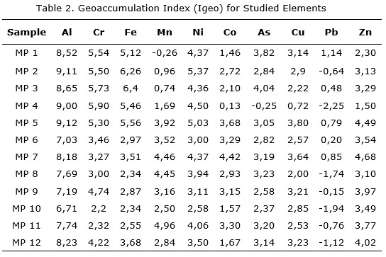
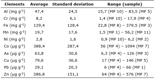
<body><![CDATA[<p><font face="verdana" size="2"><i>Lead</i></font></p>  	    <p align="justify"><font face="verdana" size="2">The concentration of lead ranges from 6 to 66 &#181;g g&#45;1. The highest concentrations are found in the mouth of Cayo Guam River (MP 1) and in the western portion of the Moa Bay Cay in MP 7 and MP 5 stations. Minimum values (below 10 &#181;g g<sup>&#45;1</sup>) were found in MP 4, MP 10 and MP 8 (Figure 2). There is no report of Pb being found in laterites so it is assumed that its origin is associated with the industrial and urban activity.</font></p>  	    <p><font face="verdana" size="2"><i>Zinc</i></font></p>  	    <p align="justify"><font face="verdana" size="2">Laterite soils contain large amounts of iron oxides, which are known to have strong zinc&#45;binding capacity (<a href="#ref11">Mandal <i>et al</i>. 1992</a>). In surface marine sediments, the concentration ranges from 64 to 576 &#181;g g<sup>&#45;1</sup>, with an average value of 286 &#181;g g<sup>&#45;1</sup> (Figure 2). The highest concentrations were found in the western portion of the Moa Bay Cay (MP 5, MP 7 and MP 9) and south of Moa Grande Cay in MP 12.</font></p>  	    <p align="justify"><font face="verdana" size="2">The accumulation of Zn, Cu and Co shows a pattern: the highest values are located in Moa Bay Cay specifically in MP 5 and MP 7 stations. The highest disposals of terrigenous sediments in this zone and the influence of dumping urban and industrial wastes on the coast is the major cause of this behavior.</font></p>  	    <p align="justify"><font face="verdana" size="2">Average, standard deviations and ranges for all samples analysed are in the supporting information (See Supporting Information SI. IV).</font></p>  	    <p><b><font face="verdana" size="2">3.3. Geoaccumulation index</font></b></p>  	    <p align="justify"><font face="verdana" size="2">Calculation results of the geoaccumulation index are shown in <a href="#t2">Table 2</a>. According to the ranges established by <a href="#ref13">M&uuml;ller (1969)</a> for the evaluation, the analysis reveals significant pollution values for Al, Cr, Fe, Ni and Zn in each station.</font></p>  	    <p align="center"><img src="/img/revistas/mg/v33n2/t0208217.jpg" name="t2" id="t2">	</p> 	    <p align="justify"><font face="verdana" size="2">A significant pollution in surface sediments in the entire region is observed by calculating the Igeo. Al is the element of greader accumulation in samples with a maximum Igeo value of 9,12 (MP 5) and a minimum value of 6,71 (MP 10). Cr, Fe and Ni are also metals with a high geoaccumulation. In general, the most contaminatedsamples were found in MP 5, MP 7, MP 2 and MP 3, indicating a significant level of pollution throughout the analyzed coastal sector.</font></p>  	    ]]></body>
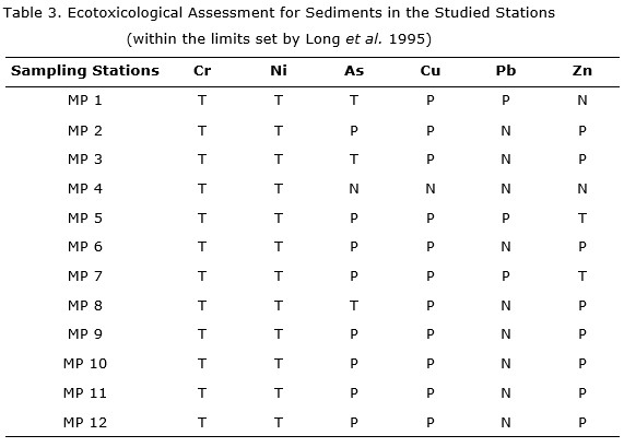
<body><![CDATA[<p align="justify"><font face="verdana" size="2">The Mn geoaccumulation was not significant in the delta zone; however, the values increase within the lagoon and reach a maximun value in the MP 11 station. Co, As and Cu are observed as recurrent contaminants in all stations, except in MP 4.</font></p>  	    <p align="justify"><font face="verdana" size="2">Of all analyzed elements, Pb had the lowest geoaccumulation because only a low degree of contamination was observed in MP 1. Negative Igeo values for Mn, As and Pb in some stations indicate that the sediments are not contaminated by these metals.</font></p>  	    <p><font face="verdana" size="2"><strong>3.4. Data interpretation based on ecotoxicological criteria</strong></font></p>  	    <p align="justify"><font face="verdana" size="2">According to the comparison between the obtained concentrations and the ecotoxicological criteria proposed by <a href="#ref10">Long <i>et al</i>. 1995</a>, the impact of pollution in the studied area is shown in <a href="#t3">Table 3</a>.</font></p>  	    <p align="center"><img src="/img/revistas/mg/v33n2/t0308217.jpg" name="t3" id="t3">	</p> 	    <p><font face="verdana" size="2">T: Toxic environment; P: Polluted environment; N: Nontoxic (see explanation in the supporting information SI.II)</font></p>  	    <p align="justify"><font face="verdana" size="2">Potentially toxic levels characterize all samples, whereas the concentrations of Cr, Ni, As, Cu, Pb, and Zn in the deltaic and coastal zone sediments express a risk for the biota. The MP 5 and MP 7 stations appear to pose the highest potential biological risk throughout the coastal zone because all the elements analyzed show a potential toxicity. All samples from the deltaic zone are toxic for Cr, Ni, As and Cu. The MP 1 is potentially toxic for Pb and two samples for Zn (stations MP 2 and MP 3).</font></p>  	    <p><font face="verdana" size="2"><b>4. CONCLUSIONS</b></font></p>  	    <p align="justify"><font face="verdana" size="2">&#183; Surface sediments from the Moa Bay Cay are characterized by having concentrations of elements that are typical of aquatic environments located in industrial and densely populated areas. This largely reflects a relation with major impact sources, which explains the role of local industrial activities in chemically altering the quality of sediments.</font></p>  	    <p align="justify"><font face="verdana" size="2">&#183; According to the Geo&#45;accumulation Index calculated for the elements, the degree of pollution ranged from unpolluted to very strongly polluted. The results revealed the following tendencies in their order of geo&#45;accumulation in the sediments: Pb &lt; Mn &lt; Co &lt; Cu &lt; As &lt; Zn &lt; N i&lt; Fe &lt; Cr &lt;Al. The Igeo for Al was the highest value while it was the lowest value for Pb. The ecotoxicological risks of sediments in Moa Bay Cay is very high, and more than 80 % of the samples pose a toxic risk for marine environments and its development.</font></p>  	    ]]></body>
<body><![CDATA[<p align="justify"><font face="verdana" size="2">&#183; Even though there is no area that can be classified to be unpolluted based on the calculated Igeo, four stations MP 5 and MP 7 in the coastal zone and MP 3 and MP 2 in the deltaic zone have been identified as critical locations of contamination. The levels of Cr, Ni, Co, As and Cu shall be strictly monitored in the future because they appear to be associated with a potential biological risk.</font></p>  	    <p align="justify"><font face="verdana" size="2">&#183; This research clearly highlights the pressing need to make great efforts to control industrial disposals in the coastal area. It also indicates that immediate measures are to be taken to minimize contamination and to prevent future pollution issues.</font></p>  	    <p align="justify"><font face="verdana" size="2">&#183; The investigation results have been considered in the definition of a specific set of geoindicators for assessing and monitoring the condition of the coastal environment and can be of great help for developing an Integrated Coastal Zone Management.</font></p>  	    <p><font face="verdana" size="2"><b>5.&nbsp; ACKNOWLEDGMENTS</b></font></p>  	    <p align="justify"><font face="verdana" size="2">The financial support from the Technical University of Clausthal, VLIR&#45;UOS, and the Program of Belgian Cooperation for the Development is highly appreciated. We would also like to take this opportunity to express our gratitude to the anonymous reviewers for their insightful comments.</font></p>  	    <p><b><font face="verdana" size="2">6. REFERENCES</font></b></p>  	    <p><font size="2" face="verdana" id="ref1">Amat, D.; Pierra, A.; Casals, I. y V&aacute;zquez, D. 2002: Estudio de la&nbsp; contaminaci&oacute;n por metales pesados en sedimentos y ostiones de la bah&iacute;a de Manzanillo, Cuba. <i>Journal of the Mexican Chemical Society</i> 46(4): 357&#45;361.</font></p>  	    <p><font size="2" face="verdana" id="ref2">Bergues, P. 2006: Presencia de perfiles later&iacute;ticos con intercalaciones at&iacute;picas y bauxitas en el sector septentrional del r&iacute;o Yagrumaje, Moa. <i>Miner&iacute;a y Geolog&iacute;a</i> 22(1): 1&#45;8.</font></p>  	    <p><font size="2" face="verdana" id="ref3">Cervantes, Y.; Almaguer, Y.; Pierra, A.; Orozco, G. y Gursky, H. 2011: Metales traza en sedimentos de la bah&iacute;a de Cayo Moa (Cuba): evaluaci&oacute;n preliminar de la contaminaci&oacute;n. <i>Miner&iacute;a y Geolog&iacute;a</i> 27(4): 1&#45;19.</font></p>  	    <p><font size="2" face="verdana" id="ref4">Cesigma.1997: Report on complete oceanographic study of the reef lagoon of Cayo Moa Bay. Prepared by CESIGMA &#150; Divisi&oacute;n Am&eacute;rica and GENECAR S.A., Report, 105 p. Unpublished.</font></p>  	    ]]></body>
<body><![CDATA[<p><font size="2" face="verdana" id="ref5">Cueto, F.; Rond&oacute;n, E. y Fuentes, R. 2003: Efluente l&iacute;quido (wl) de la tecnolog&iacute;a de lixiviaci&oacute;n &aacute;cida: alternativas de tratamiento. <i>Miner&iacute;a y Geolog&iacute;a</i> 19<i>(</i>3&#45;4): 79&#150;84.</font></p>  	    <!-- ref --><p><font size="2" face="verdana" id="ref6">Fern&aacute;ndez, Z.2009: <i>Plan de MIZC para minimizar el azolvamiento en la bah&iacute;a de Cayo Moa.</i> Master Thesis. Universidad de Oriente. Santiago de Cuba, Cuba. 106 p.    </font></p>  	    <p><font size="2" face="verdana" id="ref7">Gang, X.; Jian, L.; Shaofeng, P.; Gang, H. y Xianghuai, K. 2016: Sources and geochemical background of potentially toxic metals in surface sediments from the Zhejiang coastal mud area of the East China Sea. <i>Journal of Geochemical Exploration</i> 168: 26&#45;35.</font></p>  	    <p><font size="2" face="verdana" id="ref8">Gupta, S.; Jena, V.; Matic, N.; Kapralova, V. y Solanki, J. 2014: Assessment of geo&#45;accumulation index of heavy metal and source of contamination by multivariate factor analysis. <i>International Journal of Hazardous Materials</i> 2(2): 18&#45;22.</font></p>  	    <p><font size="2" face="verdana" id="ref9">Herrera, J; Rodr&iacute;guez, J; Coto, J; Salgado, V y Borb&oacute;n, H. 2013: Evaluaci&oacute;n de metales pesados en los sedimentos superficiales del r&iacute;o Pirro. <i>Tecnolog&iacute;a en Marcha</i> 26(1): 27&#45;36.</font></p>  	    <p><font size="2" face="verdana" id="ref10">Long, E.; Macdonald, D.; Smith, S. y Calder, F. 1995: Incidence of adverse biological effects within ranges of chemical concentrations in marine and estuarine sediments. <i>Environmental Management</i> 19(1): 81&#45;97.</font></p>  	    <p><font size="2" face="verdana" id="ref11">Mandal, B.; Chatterjee, J.; Hazra, G. y Mandal, L. 1992: Effect of preflooding on transformation of applied zinc and its uptake by rice in lateritic soils. <i>Soil Science</i> 153(3): 250&#45;257.</font></p>  	    <!-- ref --><p><font size="2" face="verdana" id="ref12">Men&eacute;ndez, M. 2001: <i>Explotaci&oacute;n racional del yacimiento de Cienos Carbonatados en la Bah&iacute;a de Cayo Moa</i>. Guardado, R. (Tutor). Master Thesis. Instituto Superior Minero Metal&uacute;rgico de Moa, Cuba. 78 p.    </font></p>  	    ]]></body>
<body><![CDATA[<p><font size="2" face="verdana" id="ref13">M&uuml;ller, G.1969: Index of geoaccumulation in sediments of the Rhine River. <i>Geology Journal</i> 2(3): 108&#150;118.</font></p>  	    <!-- ref --><p><font size="2" face="verdana" id="ref14">ONEI. 2014: Anuario estad&iacute;stico de Moa 2013. Report, Moa, Cuba.     Unpublished.</font></p>  	    <p><font size="2" face="verdana" id="ref15">Ong, M.; Menier, D.; Shazili, N. y Kamaruzzaman, B. 2013: Geochemical Characteristics of Heavy Metals Concentration in Sediments of Quiberon Bay Waters, South Brittany, France. <i>Oriental Journal of Chemistry</i> 29(1): 39&#45;45.</font></p>  	    <p><font size="2" face="verdana" id="ref16">Rojas, A.; R&oacute;mulo, S. y Orozco, G. 2012: Identificaci&oacute;n mineral&oacute;gica de los &oacute;xidos de manganeso del yacimiento later&iacute;tico Punta Gorda, Moa, Cuba. <i>Miner&iacute;a y Geolog&iacute;a</i> 28(1): 1&#45;26.</font></p>  	    <p><font size="2" face="verdana" id="ref17">Zhu, H.; Zeng, G.; Jiang, M.; Liang, J.; Zhang, C.; Yin, J.; Huang, H.; Liu, Z. y Jiang, H. 2012: Ecological risk assessment of heavy metals in sediments of Xiawan Port based on modified potential ecological risk index. <i>Trans. Nonferrous Met. Soc. China</i> 22: 1470&#45;1477.</font></p>  	    <p align="justify"><font face="verdana" size="2"><b>7. Supporting information I</b></font></p>  	    <p><font face="verdana" size="2"><b>SI. 1&#45; Assessing the degree of pollution</b></font></p>  	    <p align="justify"><font face="verdana" size="2">The index value of geoaccumulation defined by M&uuml;ller (1969) and used in several researches because of its importance as geoindicator of pollution (<a href="#ref1">Amat <i>et al</i>. 2002</a>; <a href="#ref15">ONG <i>et al</i>. 2013</a>) was used to assess sediment contamination.</font></p>  	    <p align="justify"><font face="verdana" size="2">The geoaccumulation index is defined by:</font></p>  	    ]]></body>
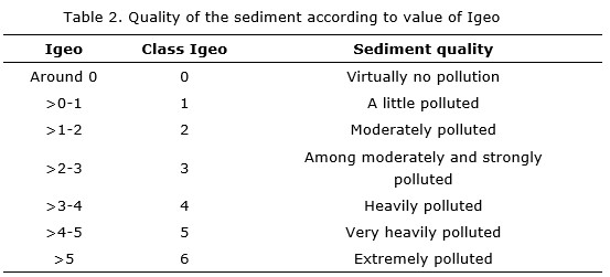
<body><![CDATA[<p align="justify"><font face="verdana" size="2">Igeo = log 2 (Cn / 1.5 Bn)</font></p>  	    <p align="justify"><font face="verdana" size="2">Where:</font></p>  	    <p align="justify"><font face="verdana" size="2">Cn = concentration of metal;</font></p>  	    <p align="justify"><font face="verdana" size="2">Bn = geochemical background value.</font></p>  	    <p align="justify"><font face="verdana" size="2">A company specialized in geographic and environmental solutions &#150; <a href="#ref4">CESIGMA &#45; (1997)</a> established the background values for Moa Bay Cay. They used as a reference by the same consultant in 2002 (<a href="#t4">Table 1</a>).</font></p>  	    <p align="center"><img src="/img/revistas/mg/v33n2/t0408217.jpg" name="t4" id="t4">	</p> 	    <p><font face="verdana" size="2">*(Salomons y F&ouml;rstener (1984))</font></p>  	    <p align="justify"><font face="verdana" size="2">In the case of arsenic the background value has not been identified in previous studies, so the value given as a world average in shallow water sediment, by Salomons y F&ouml;rstener (1984), is reported.</font></p>  	    <p align="justify"><font face="verdana" size="2">According to <a href="#ref13">M&uuml;ller (1969)</a>, the value of Igeo allows to classify sediments according to the degree of pollution, as shown in Table 2.</font></p>  	    <p align="center"><img src="/img/revistas/mg/v33n2/t0508217.jpg" name="t5" id="t5">	</p> 	    ]]></body>
<body><![CDATA[<p><font face="verdana" size="2">Source: <a href="#ref13">M&uuml;ller (1969)</a></font></p>  	    <p><font face="verdana" size="2"><b>References</b></font></p>  	    <p><font face="verdana" size="2">Amat, D.; Pierra, A.; Casals, I. y V&aacute;zquez, D. 2002: Estudio de la contaminaci&oacute;n por metales pesados en sedimentos y ostiones de la bah&iacute;a de Manzanillo, Cuba. <i>Journal of the Mexican Chemical Society</i>46(4): 357&#45;361.</font></p>  	    <p><font face="verdana" size="2">Cesigma. 1997: Report on complete oceanographic study of the reef lagoon of Cayo Moa Bay. Prepared by CESIGMA &#150; Divisi&oacute;n Am&eacute;rica and GENECAR S.A., Report, 105 p. Unpublished.</font></p>  	    <p><font face="verdana" size="2">M&uuml;ller, G. 1969: Index of geoaccumulation in sediments of the Rhine River. <i>Geology Journal</i> 2(3): 108&#150;118.</font></p>  	    <p><font face="verdana" size="2">Ong, M.; Menier, D.; Shazili, N. y Kamaruzzaman, B. 2013: Geochemical Characteristics of Heavy Metals Concentration in Sediments of Quiberon Bay Waters, South Brittany, France. <i>Oriental Journal of Chemistry</i> 29(1): 39&#45;45.</font></p>  	    <p><font face="verdana" size="2">Salomons, W. y F&ouml;rstner, U. 1984: <i>Metals in the Hydrocycle.</i> Springer&#45;Verlag, Berlin, Germany. 352 p. ISBN: 978&#45;3642693274.</font>	</p> 	    <p><font face="verdana" size="2"><b>8. Supporting information II</b></font></p>  	    <p><font face="verdana" size="2"><b>SI. II &#45;</b> <b>Data analysis based on quality criteria</b></font></p>  	    <p align="justify"><font face="verdana" size="2">In order to interpret the information based on ecotoxicological criteria the limits proposed by <a href="#ref10">Long <i>et al</i>. (1995)</a> were used. Two reference values for the concentration of metals in sediment are considered: the lowest concentration that may have adverse effects on living beings (ERL) and the maximum tolerable level (ERM). Concentrations exceeding the latter values are considered very toxic (Accornero, Gnerre y Manfra 2008).</font></p>  	    ]]></body>
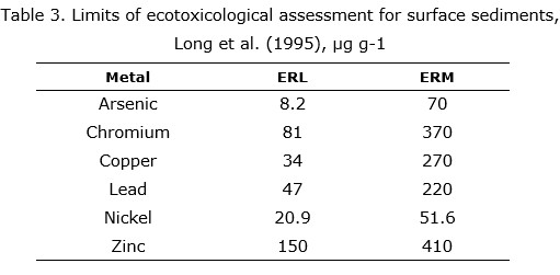
<body><![CDATA[<p align="justify"><font face="verdana" size="2">According to <a href="#ref10">Long <i>et al.</i> (1995)</a>:</font></p>  	    <p align="justify"><font face="verdana" size="2">&#183; If the metal concentration is below ERL, contamination is not significant.</font></p>  	    <p align="justify"><font face="verdana" size="2">&#183; If the concentration of the metal exceeds ERL, but is below ERM, environment is polluted.</font></p>  	    <p align="justify"><font face="verdana" size="2">&#183; If the concentration exceeds ERM, the environment is toxic.</font></p>  	    <p align="justify"><font face="verdana" size="2">These researchers identified and studied the effects on organisms and ecosystems of the accumulation of nine elements (As, Cr, Cd, Pb, Cu, Ni, Zn, Hg, and Ag) and their criteria have been widely accepted and based on studies conducted by the Environmental Protection Agency of the USA (USEPA) and by Accornero, Gnerre y Manfra (2008). Table 3 shows the limits for ecotoxicological assessment for As, Cr, Cu, Pb, Ni and Zn proposed by <a href="#ref10">Long <i>et al.</i> (1995)</a> for surface sediment.</font></p>  	    <p align="center"><img src="/img/revistas/mg/v33n2/t0608217.jpg" name="t3" id="t3">	</p> 	    <p><font face="verdana" size="2"><b>References</b></font></p>  	    <p><font face="verdana" size="2">Accornero, A.; Gnerre, R. y Manfra, L. 2008: Sediment concentrations of trace metals in the Berre Lagoon (France): An assessment of contamination. <i>Archives of Environmental Contamination and Toxicology</i> 54(3): 372&#45;385.</font></p>  	    <p><font face="verdana" size="2">Long, E.; Macdonald, D.; Smith, S. y Calder, f. 1995: Incidence of adverse biological effects within ranges of chemical concentrations in marine and estuarine sediments. <i>Environmental Management</i> 19(1): 81&#45;97.</font>	</p> 	    <p><font face="verdana" size="2"><b>9. Supporting information III</b></font></p>  	    ]]></body>
<body><![CDATA[<p><font face="verdana" size="2"><b>SI. III &#45;</b> <b>Factorial analysis (Use <i>SPSS STATISTICS</i> software)</b></font></p>  	    <p align="justify"><font face="verdana" size="2">FACTOR</font></p>  	    <p><font face="verdana" size="2">&nbsp; /VARIABLES Al Cr Fe Mn Ni Co As Cu Pb Zn</font></p>      <p><font face="verdana" size="2">&nbsp; /MISSING LISTWISE</font></p>  	    <p><font face="verdana" size="2">&nbsp; /ANALYSIS Al Cr Fe Mn Ni Co As Cu Pb Zn</font></p>  	    <p><font face="verdana" size="2">&nbsp; /PRINT UNIVARIATE INITIAL CORRELATION SIG DET KMO INV REPR AIC EXTRACTION ROTATION FSCORE</font></p>  	    <p><font face="verdana" size="2">&nbsp; /FORMAT SORT</font></p>  	    <p><font face="verdana" size="2">&nbsp; /CRITERIA MINEIGEN (1) ITERATE (25)</font></p>  	    <p><font face="verdana" size="2">&nbsp; /EXTRACTION PC</font></p>  	    <p><font face="verdana" size="2">&nbsp; /CRITERIA ITERATE (25)</font></p>  	    ]]></body>
<body><![CDATA[<p><font face="verdana" size="2">&nbsp; /ROTATION VARIMAX</font></p>  	    <p><font face="verdana" size="2">&nbsp; /METHOD=CORRELATION.</font>	</p> 	    <p align="center"><img src="/img/revistas/mg/v33n2/t0708217.jpg" name="t4" id="t4"></p> 	    <p align="center"><img src="/img/revistas/mg/v33n2/t0808217.jpg" name="t5" id="t5"></p> 	    <p><font face="verdana" size="2">Extraction method: Principal component analysis.</font></p>     <p><font face="verdana" size="2">Rotation method: Varimax with Kaiser normalization.</font></p>         <p><b><font face="verdana" size="2">10. Supporting information IV</font></b></p>  	    <p><font face="verdana" size="2"><b>SI. IV &#45;</b> <b>Average, standard deviation and ranges of values for the elements studied</b></font></p>     <p align="center"><img src="/img/revistas/mg/v33n2/t0908217.jpg"></p> 	    <p>&nbsp;</p> 	    ]]></body>
<body><![CDATA[<p>&nbsp;</p> 	    <p><font face="verdana" size="2">Recibido: 09/03/2017</font><font face="verdana" size="2">    <br>     Aprobado: 08/04/2017</font></p> 	    <p>&nbsp;</p> 	    <p>&nbsp;</p> 	    <p><font face="verdana" size="2"><i>Yosbanis Cervantes Guerra,</i> Higher Mining and Metallurgist Institute of Moa, Cuba <a href="mailto:ycervantes@ismm.edu.cu">ycervantes@ismm.edu.cu</a></font></p>      ]]></body><back>
<ref-list>
<ref id="B1">
<nlm-citation citation-type="journal">
<person-group person-group-type="author">
<name>
<surname><![CDATA[Amat]]></surname>
<given-names><![CDATA[D.]]></given-names>
</name>
<name>
<surname><![CDATA[Pierra]]></surname>
<given-names><![CDATA[A.]]></given-names>
</name>
<name>
<surname><![CDATA[Casals]]></surname>
<given-names><![CDATA[I.]]></given-names>
</name>
<name>
<surname><![CDATA[Vázquez]]></surname>
<given-names><![CDATA[D.]]></given-names>
</name>
</person-group>
<article-title xml:lang="es"><![CDATA[Estudio de la contaminación por metales pesados en sedimentos y ostiones de la bahía de Manzanillo, Cuba.]]></article-title>
<source><![CDATA[Journal of the Mexican Chemical Society]]></source>
<year></year>
<volume>46</volume>
<numero>4</numero>
<issue>4</issue>
<page-range>357-361</page-range></nlm-citation>
</ref>
<ref id="B2">
<nlm-citation citation-type="journal">
<person-group person-group-type="author">
<name>
<surname><![CDATA[Bergues]]></surname>
<given-names><![CDATA[P.]]></given-names>
</name>
</person-group>
<article-title xml:lang="es"><![CDATA[Presencia de perfiles lateríticos con intercalaciones atípicas y bauxitas en el sector septentrional del río Yagrumaje, Moa]]></article-title>
<source><![CDATA[Minería y Geología]]></source>
<year></year>
<volume>22</volume>
<numero>1</numero>
<issue>1</issue>
<page-range>1-8</page-range></nlm-citation>
</ref>
<ref id="B3">
<nlm-citation citation-type="journal">
<person-group person-group-type="author">
<name>
<surname><![CDATA[Cervantes]]></surname>
<given-names><![CDATA[Y.]]></given-names>
</name>
<name>
<surname><![CDATA[Almaguer]]></surname>
<given-names><![CDATA[Y.]]></given-names>
</name>
<name>
<surname><![CDATA[Pierra]]></surname>
<given-names><![CDATA[A.]]></given-names>
</name>
<name>
<surname><![CDATA[Orozco]]></surname>
<given-names><![CDATA[G.]]></given-names>
</name>
<name>
<surname><![CDATA[Gursky]]></surname>
<given-names><![CDATA[H.]]></given-names>
</name>
</person-group>
<article-title xml:lang="es"><![CDATA[Metales traza en sedimentos de la bahía de Cayo Moa (Cuba): evaluación preliminar de la contaminación.]]></article-title>
<source><![CDATA[Minería y Geología]]></source>
<year></year>
<volume>27</volume>
<numero>4</numero>
<issue>4</issue>
<page-range>1-19</page-range></nlm-citation>
</ref>
<ref id="B4">
<nlm-citation citation-type="book">
<collab>Cesigma</collab>
<source><![CDATA[Report on complete oceanographic study of the reef lagoon of Cayo Moa Bay]]></source>
<year>1997</year>
<publisher-name><![CDATA[Prepared by CESIGMA - División América and GENECAR S.A.]]></publisher-name>
</nlm-citation>
</ref>
<ref id="B5">
<nlm-citation citation-type="journal">
<person-group person-group-type="author">
<name>
<surname><![CDATA[Cueto]]></surname>
<given-names><![CDATA[F.]]></given-names>
</name>
<name>
<surname><![CDATA[Rondón]]></surname>
<given-names><![CDATA[E.]]></given-names>
</name>
<name>
<surname><![CDATA[Fuentes]]></surname>
<given-names><![CDATA[R.]]></given-names>
</name>
</person-group>
<article-title xml:lang="es"><![CDATA[Efluente líquido (wl) de la tecnología de lixiviación ácida: alternativas de tratamiento.]]></article-title>
<source><![CDATA[Minería y Geología]]></source>
<year></year>
<volume>19</volume>
<numero>3-4</numero>
<issue>3-4</issue>
<page-range>79-84</page-range></nlm-citation>
</ref>
<ref id="B6">
<nlm-citation citation-type="book">
<person-group person-group-type="author">
<name>
<surname><![CDATA[Fernández]]></surname>
<given-names><![CDATA[Z.]]></given-names>
</name>
</person-group>
<source><![CDATA[Plan de MIZC para minimizar el azolvamiento en la bahía de Cayo Moa.]]></source>
<year>2009</year>
<publisher-loc><![CDATA[Santiago de Cuba ]]></publisher-loc>
<publisher-name><![CDATA[Universidad de Oriente]]></publisher-name>
</nlm-citation>
</ref>
<ref id="B7">
<nlm-citation citation-type="journal">
<person-group person-group-type="author">
<name>
<surname><![CDATA[Gang]]></surname>
<given-names><![CDATA[X.]]></given-names>
</name>
<name>
<surname><![CDATA[Jian]]></surname>
<given-names><![CDATA[L.]]></given-names>
</name>
<name>
<surname><![CDATA[Shaofeng]]></surname>
<given-names><![CDATA[P.]]></given-names>
</name>
<name>
<surname><![CDATA[Gang]]></surname>
<given-names><![CDATA[H.]]></given-names>
</name>
<name>
<surname><![CDATA[Xianghuai]]></surname>
<given-names><![CDATA[K.]]></given-names>
</name>
</person-group>
<article-title xml:lang="en"><![CDATA[Sources and geochemical background of potentially toxic metals in surface sediments from the Zhejiang coastal mud area of the East China Sea.]]></article-title>
<source><![CDATA[Journal of Geochemical Exploration]]></source>
<year></year>
<volume>168</volume>
<page-range>26-35</page-range></nlm-citation>
</ref>
<ref id="B8">
<nlm-citation citation-type="journal">
<person-group person-group-type="author">
<name>
<surname><![CDATA[Gupta]]></surname>
<given-names><![CDATA[S.]]></given-names>
</name>
<name>
<surname><![CDATA[Jena]]></surname>
<given-names><![CDATA[V.]]></given-names>
</name>
<name>
<surname><![CDATA[Matic]]></surname>
<given-names><![CDATA[N.]]></given-names>
</name>
<name>
<surname><![CDATA[Kapralova]]></surname>
<given-names><![CDATA[V.]]></given-names>
</name>
<name>
<surname><![CDATA[Solanki]]></surname>
<given-names><![CDATA[J.]]></given-names>
</name>
</person-group>
<article-title xml:lang="en"><![CDATA[Assessment of geo-accumulation index of heavy metal and source of contamination by multivariate factor analysis]]></article-title>
<source><![CDATA[International Journal of Hazardous Materials]]></source>
<year></year>
<volume>2</volume>
<numero>2</numero>
<issue>2</issue>
<page-range>18-22</page-range></nlm-citation>
</ref>
<ref id="B9">
<nlm-citation citation-type="journal">
<person-group person-group-type="author">
<name>
<surname><![CDATA[Herrera]]></surname>
<given-names><![CDATA[J.]]></given-names>
</name>
<name>
<surname><![CDATA[Rodríguez]]></surname>
<given-names><![CDATA[J.]]></given-names>
</name>
<name>
<surname><![CDATA[Coto]]></surname>
<given-names><![CDATA[J.]]></given-names>
</name>
<name>
<surname><![CDATA[Salgado]]></surname>
<given-names><![CDATA[V.]]></given-names>
</name>
<name>
<surname><![CDATA[Borbón]]></surname>
<given-names><![CDATA[H.]]></given-names>
</name>
</person-group>
<article-title xml:lang="es"><![CDATA[Evaluación de metales pesados en los sedimentos superficiales del río Pirro.]]></article-title>
<source><![CDATA[Tecnología en Marcha]]></source>
<year></year>
<volume>26</volume>
<numero>1</numero>
<issue>1</issue>
<page-range>27-36</page-range></nlm-citation>
</ref>
<ref id="B10">
<nlm-citation citation-type="journal">
<person-group person-group-type="author">
<name>
<surname><![CDATA[Long]]></surname>
<given-names><![CDATA[E.]]></given-names>
</name>
<name>
<surname><![CDATA[Macdonald]]></surname>
<given-names><![CDATA[D.]]></given-names>
</name>
<name>
<surname><![CDATA[Smith]]></surname>
<given-names><![CDATA[S.]]></given-names>
</name>
<name>
<surname><![CDATA[Calder]]></surname>
<given-names><![CDATA[F.]]></given-names>
</name>
</person-group>
<article-title xml:lang="en"><![CDATA[Incidence of adverse biological effects within ranges of chemical concentrations in marine and estuarine sediments.]]></article-title>
<source><![CDATA[Environmental Management]]></source>
<year></year>
<volume>19</volume>
<numero>1</numero>
<issue>1</issue>
<page-range>81-97</page-range></nlm-citation>
</ref>
<ref id="B11">
<nlm-citation citation-type="journal">
<person-group person-group-type="author">
<name>
<surname><![CDATA[Mandal]]></surname>
<given-names><![CDATA[B.]]></given-names>
</name>
<name>
<surname><![CDATA[Chatterjee]]></surname>
<given-names><![CDATA[J.]]></given-names>
</name>
<name>
<surname><![CDATA[Hazra]]></surname>
<given-names><![CDATA[G.]]></given-names>
</name>
<name>
<surname><![CDATA[Mandal]]></surname>
<given-names><![CDATA[L.]]></given-names>
</name>
</person-group>
<article-title xml:lang="en"><![CDATA[Effect of preflooding on transformation of applied zinc and its uptake by rice in lateritic soils]]></article-title>
<source><![CDATA[Soil Science]]></source>
<year></year>
<volume>153</volume>
<numero>3</numero>
<issue>3</issue>
<page-range>250-257</page-range></nlm-citation>
</ref>
<ref id="B12">
<nlm-citation citation-type="book">
<person-group person-group-type="author">
<name>
<surname><![CDATA[Menéndez]]></surname>
<given-names><![CDATA[M.]]></given-names>
</name>
</person-group>
<source><![CDATA[Explotación racional del yacimiento de Cienos Carbonatados en la Bahía de Cayo Moa.]]></source>
<year>2001</year>
<publisher-name><![CDATA[Instituto Superior Minero Metalúrgico de Moa]]></publisher-name>
</nlm-citation>
</ref>
<ref id="B13">
<nlm-citation citation-type="journal">
<person-group person-group-type="author">
<name>
<surname><![CDATA[Müller]]></surname>
<given-names><![CDATA[G.]]></given-names>
</name>
</person-group>
<article-title xml:lang="en"><![CDATA[Index of geoaccumulation in sediments of the Rhine River.]]></article-title>
<source><![CDATA[Geology Journal]]></source>
<year></year>
<volume>2</volume>
<numero>3</numero>
<issue>3</issue>
<page-range>108-118</page-range></nlm-citation>
</ref>
<ref id="B14">
<nlm-citation citation-type="">
<collab>ONEI</collab>
<source><![CDATA[Anuario estadístico de Moa 2013.]]></source>
<year>2014</year>
<publisher-loc><![CDATA[Moa ]]></publisher-loc>
</nlm-citation>
</ref>
<ref id="B15">
<nlm-citation citation-type="journal">
<person-group person-group-type="author">
<name>
<surname><![CDATA[Ong]]></surname>
<given-names><![CDATA[M.]]></given-names>
</name>
<name>
<surname><![CDATA[Menier]]></surname>
<given-names><![CDATA[D.]]></given-names>
</name>
<name>
<surname><![CDATA[Shazili]]></surname>
<given-names><![CDATA[N.]]></given-names>
</name>
<name>
<surname><![CDATA[Kamaruzzaman]]></surname>
<given-names><![CDATA[B.]]></given-names>
</name>
</person-group>
<article-title xml:lang="en"><![CDATA[Geochemical Characteristics of Heavy Metals Concentration in Sediments of Quiberon Bay Waters, South Brittany, France.]]></article-title>
<source><![CDATA[Oriental Journal of Chemistry]]></source>
<year></year>
<volume>29</volume>
<numero>1</numero>
<issue>1</issue>
<page-range>39-45</page-range></nlm-citation>
</ref>
<ref id="B16">
<nlm-citation citation-type="journal">
<person-group person-group-type="author">
<name>
<surname><![CDATA[Rojas]]></surname>
<given-names><![CDATA[A.]]></given-names>
</name>
<name>
<surname><![CDATA[Rómulo]]></surname>
<given-names><![CDATA[S.]]></given-names>
</name>
<name>
<surname><![CDATA[Orozco]]></surname>
<given-names><![CDATA[G.]]></given-names>
</name>
</person-group>
<article-title xml:lang="es"><![CDATA[Identificación mineralógica de los óxidos de manganeso del yacimiento laterítico Punta Gorda, Moa, Cuba.]]></article-title>
<source><![CDATA[Minería y Geología]]></source>
<year></year>
<volume>28</volume>
<numero>1</numero>
<issue>1</issue>
<page-range>1-26</page-range></nlm-citation>
</ref>
<ref id="B17">
<nlm-citation citation-type="journal">
<person-group person-group-type="author">
<name>
<surname><![CDATA[Zhu]]></surname>
<given-names><![CDATA[H.]]></given-names>
</name>
<name>
<surname><![CDATA[Zeng]]></surname>
<given-names><![CDATA[G.]]></given-names>
</name>
<name>
<surname><![CDATA[Jiang]]></surname>
<given-names><![CDATA[M.]]></given-names>
</name>
<name>
<surname><![CDATA[Liang]]></surname>
<given-names><![CDATA[J.]]></given-names>
</name>
<name>
<surname><![CDATA[Zhang]]></surname>
<given-names><![CDATA[C.]]></given-names>
</name>
<name>
<surname><![CDATA[Yin]]></surname>
<given-names><![CDATA[J.]]></given-names>
</name>
<name>
<surname><![CDATA[Huang]]></surname>
<given-names><![CDATA[H.]]></given-names>
</name>
<name>
<surname><![CDATA[Liu]]></surname>
<given-names><![CDATA[Z.]]></given-names>
</name>
<name>
<surname><![CDATA[Jiang]]></surname>
<given-names><![CDATA[H.]]></given-names>
</name>
</person-group>
<article-title xml:lang="en"><![CDATA[Ecological risk assessment of heavy metals in sediments of Xiawan Port based on modified potential ecological risk index]]></article-title>
<source><![CDATA[Trans. Nonferrous Met. Soc. China]]></source>
<year></year>
<volume>22</volume>
<page-range>1470-1477</page-range></nlm-citation>
</ref>
</ref-list>
</back>
</article>