


 Custom services
 English (pdf)
 Article in xml format
 Article references
 Send this article by e-mail
 Cited by SciELO
  Similars in
SciELO
Similars in
SciELO 
 Permalink
INTRODUCTION
It is currently estimated that 840 million people, 11% of the world's population, have little or no access to electricity and more than 80% of those suffering from energy poverty live in rural areas (World Bank Energy, 2019). Energy services are fundamental for economic and social development, and play a basic role in the eradication of poverty, the assurance of the quality of life and the development of rural areas. The 2030 Agenda for Sustainable Development establishes in its 7th objective “Ensure access to affordable, reliable, sustainable and modern energy for all by 2030” (ONU, 2015).
“Renewable energies have some geographical characteristics that differentiate them from other energy sources. For example, they have a greater geographical dispersion than conventional sources, so you can always count on some native RES” (Domínguez, 2002). Therefore, they are very conducive to electrification in rural areas, in addition, they contribute to diversification, complementarity in the energy system and to reduce dependence on fossil fuels. This wealth of renewables implies, on the other hand, a level of complexity of the system much greater than the supply by conventional sources, characterized mainly by the geographical specialization between supply and demand, with a concentrated generation model and large centers of consumption distant from the resources and generation.
The Cuban Society for the Promotion of Renewable Sources of Energy and Environmental Respect (Cubasolar) is a Non-Governmental Organization (NGO), which aims to contribute to the development of activities aimed at knowledge and rational use of renewable sources of energy, in solving the economic and social problems of the country (Bérriz, et al., 2000).
The Provincial Delegation of Cubasolar in Las Tunas, faces a series of inconveniences to select the areas needed and where electrification is feasible using RES. There are difficulties in obtaining accurate data about the location and size of the communities to be electrified, the result of the great distances that separate the settlements, which have a dispersed pattern. Many of these homes, being in poor condition, located in rural areas of difficult access and with few resources at their disposal, are abandoned, so from year to year the number and disposition of these vary (González Mejías, 2017).
In the decision-making process, information is handled in different formats and of different nature. These tasks are tedious and large consumers of time and resources, being usually compromised by the lack of information, which is often not available or comes from sources with different characteristics. This uncertainty in the starting data can compromise the results and delay the approval of the project by the relevant entities (Pinedo, 2012). The main problems facing the decision-making process associated with the electrification of rural homes using RES in Las Tunas province are:
Lack of knowledge of the renewable potential in the region under study.
Shortage of updated information about the location and size of the communities to be electrified, as well as the existing electricity grid.
Little availability of geographic data of the region under study.
Planning and decision making based on calculations performed manually can be costly in terms of money and time, resulting in non-standardized solutions. Computer applications can be a great support in this type of process, reducing the time spent and improving the quality of the result. Geographic Information Systems (GIS), have reached a high level of maturity and have emerged as a powerful tool to build electrification strategies. They can manipulate, process, analyze large amounts of spatial data and support decision-making for the spatial deployment of technologies that exploit RES (Charabi, et al., 2011).
Several models (Ellman, 2015; Kemausuor, et al., 2014; Mentis, et al., 2017; Pinedo Pascua, 2010) that consider the spatial component have been proposed for the evaluation of the mode of generation (considering renewable sources) and electrification more effective. Most of these are based on a techno-economic valuation that helps to make largescale technological decisions about the different modes of electrification, but present limitations as they do not consider criteria and concepts of territorial ordering, so as to avoid conflicts in land use or the preservation of resources and the environment; key aspects to ensure the use of available resources and limit development in sensitive areas. To solve the problem described above, was set the objective to develop a tool based on GIS that would allow planning of rural electrification taking into account criteria of the territorial ordering of the renewable sources.
MATERIALS AND METHODS
In Cuba, María Rodríguez's research (Rodríguez, 2011) has been used as a background, in which a methodology is defined that, using a GIS, allows the creation of maps for the territorial ordering of renewable energies and calculating the viable areas for the application of each type of energy to the island of Cuba. On these bases, the integration of energy and environmental elements in a geoportal was proposed to display information interactively through maps and serve as an instrument for decision makers in the proper planning of territorial energy development.
Although this research (Rodríguez, 2011) proposed a methodology that is useful for the spatial deployment of the RES, the application of this methodology becomes difficult for users who do not have training in the use of GIS. In this sense, to obtain the maps of the suitability of the areas for the investment of renewable energy systems, the user must calculate the protection perimeters individually for each layer and then combine them. In the same way it becomes awkward to check through the functionalities of a GIS the intersection between the area of a house, renewable resources and non-viable areas. This procedure may become delayed and cause errors if a large group of houses is required to be analyzed.
According to (Ghazanfar Khan, et al., 2014), when developing a tool in a GIS environment, the following steps must be taken:
a) Identify the criteria, to make thematic maps associated with the criteria, which will influence the process.
b) Identify the appropriate software support, which is capable of handling the identified criteria.
c) Build the software support in the GIS environment and
d) Analysis.
Criteria to be used for the analysis of rural areas without electricity in Las Tunas province
"A criterion is a measurable facet of a judgment, which makes it possible to illustrate and enumerate alternatives in a decision" (Ghazanfar Khan, et al., 2014). The criteria to be used for the analysis of rural areas without electricity were classified based on their connotation in: analysis criteria (they are those that enhance the selection or adaptation of the site and have positive connotation) and exclusion criteria (are those that restrict the alternatives and have negative connotation). The analysis criteria were adopted: distance to the main roads, distance to the electrical network and renewable sources of energy available.
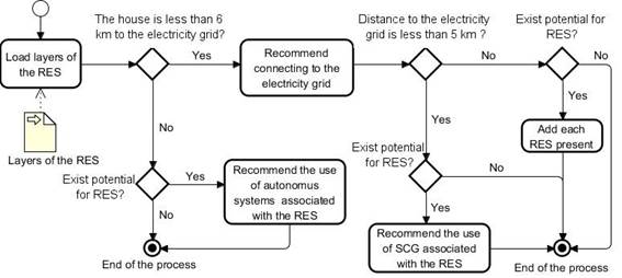
Based on the researches analyzed (Madruga, 2008; Rodríguez, 2011; Shiota Akio, 2002), the following parameters were adopted to recommend the use of energy sources in the electrification of homes:
Recommend connecting to the electricity grid if the house is less than 6 km from it.
If the distance to the electricity network is less than 5 km and in the area some of the renewable sources of water, biomass and solar are available in that order, recommend the use of the systems connected to the electricity grid (SCG) associated with those RES.
If the house is more than 6 km from the electricity grid, the autonomous systems (AS) associated with the water, biomass, wind and solar RES will be recommended in that order, if the resource is available in the area of the house. In the case of the solar resource, it is known that its potential is adequate throughout the province.
Although wind energy will be recommended, if there is potential in the area, periodic studies should always be carried out to see the stability of the wind before carrying out its exploitation.
Exclusion criteria
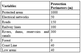
These criteria define the areas where systems should not be installed, to ensure the use of resources in the appropriate areas. Were chosen the criteria and perimeters of protection used by (Rodríguez, 2011) for the delimitation of viable and non-viable areas for the implementation of energy systems. As recommended by the methodology proposed in (Rodríguez, 2011), in stage I, the standards and criteria were studied for updating. In this sense, it was considered appropriate to add to the previous ones, the following restriction criteria that respond to different land uses:
Forests: refers to forested areas. As there is no stipulation on the number of meters to be respected to carry out a construction near a forested area, therefore the protection perimeter will be set at 0 meters.
Coast line: sets the boundary of the coastal zone4.
Low zones: it represents the areas with danger of penetration of the sea, they are associated with swamps and the presence of mangroves.
The line of coasts and the low zones are closely related, since the perimeter of protection of the coastal zone varies depending on the type of coast as established in article 2 of Decree-Law 212. In this sense, a perimeter of protection of 20 meters is established from the limit of the coastal zone. If the adjoining area is a coastal lagoon with mangroves, the boundary to land will be given by the maximum penetration of the mangrove forest. If swamp vegetation appears, the limit will be set by the outer edge towards the land of said forest (Rey Santos, et al., 2008). It was considered unnecessary to use the slope criteria, since the geography of Las Tunas province is characterized by the predominance of plains. Next, all the restriction criteria to be used are shown in Table 1.
Description of the tool
The tool developed is based on a plugin for QGIS, which is compatible with the versions 2.x. This implements the functionalities: "Determine sensitive areas", "Calculate distances to the electrical network and the main roads", "Longitude of low voltage lines", "Analyze rural housing" and "Update community data". When activating the plugin, these five functionalities are added to the “Add-ons” menu and to the QGIS toolbar. The hardware requirements are suggested for the use of the plugin: Core I3 processor of 2.5 GHz or higher and at least 3 GB of RAM and 10 GB of hard disk. Although the plugin could perform well on a computer with lower capability, the performance will vary depending on the amount of geometry contained in the layers to be processed. Each of the functionalities are described below.
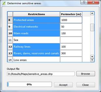
Determine sensitive areas
In a first step the non-viable areas are determined, for this purpose the “Determine sensitive areas” functionality was implemented. This functionality carries out an implementation of stages I, II and III of the methodology designed by (Rodríguez, 2011). The interface of this functionality (See Figure 1) shows a form for the user to select the layers that correspond to the restriction criteria and establish the values of the protection perimeters. Also, must specify the path where the file will be saved with sensitive areas.
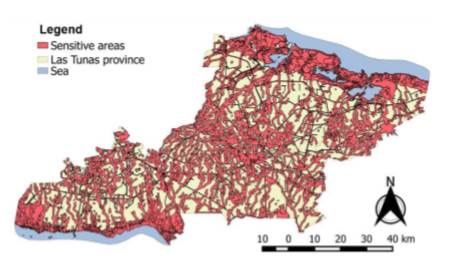
Finally, when the user completes the fields with correct values and presses the "Accept" button, the vector file containing the results is generated (See Figure 2). This is made from the combination of the geometries contained in the selected layers and their respective perimeters.
Calculate distances to the electrical network and the main roads
This functionality allows to obtain the distances (expressed in meters) from each house or community to the electricity grid or to the main roads. The user must complete the following form fields (See Figure 3):
Source point’s layer: field for select the layer that corresponds to the layer of houses or communities.
Source layer ID attribute: name of the identifying attribute of the input layer.
Destination lines layer: field for select the layer that corresponds to the electrical network or main roads.
Destination layer ID attribute: name of the identifying attribute of the destination layer.
Output attribute name: field where the distances will be saved. The user has the option to add a new attribute to the source points layer or select one of the existing ones for be updated.
When the user completes the fields correctly and press the "Accept" button, will be calculated for each point of the input layer the closest distance to the lines contained in the destination layer.
Longitude of low voltage lines
This functionality allows to calculate the length of low voltage lines (expressed in meters) necessary to connect the houses of a community to a transformation system located in its geometric center. The user must complete the following fields of the form (See Figure 4):
Houses layer: field to select the layer that contains the houses without electricity.
Unique input ID field: identifying attribute of the houses layer.
Output attribute name: Field where the distances will be saved. The user has the option of adding a new attribute to the houses layer, or selecting one of the existing ones.
Communities layer: field to select the layer that contains the communities.
When the user completes the fields correctly and press the "Accept" button, the distance to their geometric center will be calculated for the houses of the same community. This procedure was carried out as follows, first a convex polygon was generated that contained the homes of each community, for this was used the algorithm: Convex hull. The Polygon centroids algorithm was then used to create the centroids of the polygons and finally, through the Hub Distance algorithm, the distances from the houses to the centroids were calculated.
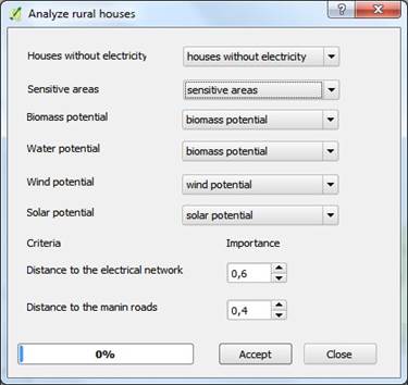
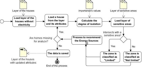
Analyze rural houses
With the “Analyze rural houses” functionality, an analysis of rural homes without electricity is carried out and are incorporated the attributes: Type of Area (“limited” or “not limited”, in case it coincides with a sensitive area or not),
Degree of Isolation (calculated based on the distance to the electricity grid and the main roads) and Source of Energy (SE) that is recommended to be implemented in the house. For a better understanding of this process see the Figure 6. General diagram of the process to analyze rural houses and Figure 7. Diagram of the process to recommend the use of Energy Sources.
The interface of this functionality consists of a form (See Figure 5) where the user must specify the maps: houses without electricity, sensitive areas and those corresponding to each renewable source (biomass, water, wind and solar). Below are the fields to establish the “importance” (value between 0 and 1) that will have the analysis criteria’s: distance to the electrical network and distance to the main roads, in the calculation of the attribute Isolation Degree (GA) of the houses. The formula for calculating this attribute is shown below in equation 1.
 (1)
(1)
Where:
→ distance of the house to the electrical network
 → distance to the main roads → importance
Finally, when the user completes the fields with the correct values and presses the “Accept” button, the aforementioned attributes are added to the vector file of the houses with the results of the analysis.

Fig.3 Interface of the functionality for calculate distances to the electrical network and the main roads

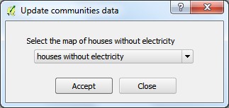
Update communities data
This functionality updates for each community contained in the layer the fields: number of homes, insolation (average of their homes), potential (renewable potentials available in their homes) and length of low voltage lines (sum of the lengths of their homes). So if new homes are added or their attributes are modified, the data of the communities can be updated to maintain their integrity.
When selecting the submenu: “Update community data” (See Figure 8), a form is displayed to specify the map of houses without electricity. If the user does not specify the correct map, pressing the "Accept" button will show an error message. When the correct map is established, the data of the communities will be updated and a message will be displayed indicating that the process has been successfully completed.
RESULTS AND DISCUSSION
Taking into account the values of the attribute, “SE recommended”, there are 567 homes that are less than 6 km from the electricity grid and where it was recommended to connect them to this.
54 houses belonging to the communities: Omaja (Majibacoa), Naranjal and Peladero (Las Tunas), Cordero (Vázquez, Puerto Padre) and Tania (Manatí) have a distance between 5 and 6 km from the electricity grid.
513 homes have the potential to implement SCG because they are less than 5 km from the electricity grid: o 5 with water energy, Gramal community, Manatí municipality. o 5 with wind power, San Lorenzo community, Las Tunas municipality.
In 46 energy could be obtained from biomass, in the communities: Guanito, La Herradura, La Ciguapa, Rio Naranjo, Naranjo and El Sao, of the municipality Majibacoa. Vedado 3 and La Piedra communities of Jesús Menéndez municipality, Sandino of Puerto Padre and La Julia municipality, El Sao, El Manantial and Las Gordas of Colombia municipality.
In 513 there is solar potential to implement photovoltaic systems connected to the electricity grid.
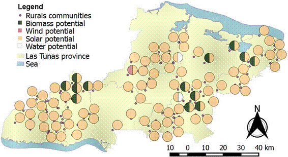
They are located more than 6 km from the electrical network, only 21 houses, in a range between 6.04 km and 12.5 km approximately and where the use of the Autonomous Photovoltaic Systems (SFA) was recommended. With respect to the variable type of area, it was detected that of the total of 588 homes, 326 coincide with a limited area. In this sense, it is necessary to assess in each case which restriction criteria it coincides with and how many meters, because as explained previously, there are homes that for a few meters, coincide with a sensitive area. In the 115 rural communities there is solar potential, in 17 communities there is biomass potential, in three communities there is water potential and only in the community of San Lorenzo belonging to the Las Tunas municipality, there is wind potential.
The potentials present in each community are shown in the form of pies diagrams in Figure 9.
As can be seen in the figure with this information obtained in the research, decision makers and planners can develop programs for the implementation of RES in the province in rural areas, being of special significance in the economic order by introducing technologies that are sustainable. In addition to social impact by providing a service that helps improve the living conditions of the populations that inhabit these territories. The analysis of the results shows that the province of Las Tunas has potential for the exploitation of renewable energies: solar, water, wind and biomass and that these could be used to energize rural homes without electricity that are far from the electrical network.
CONCLUSIONS
The study of research associated with the planning of rural electrification with RES made it possible to determine that GIS are a powerful tool for manipulating, processing, analyzing large amounts of spatial data and supporting decision-making in the spatial deployment of these systems. The ExamZonas plugin is capable of recommending the energy source to be used to electrify each house in the study area, for this it establishes a priority among the available RES. In addition, it facilitates the identification of the areas farthest from the electrical network and the main roads. The tools provided by QGIS, together with the functionalities added with the ExamZonas plugin, as well as the maps corresponding to the criteria and renewable potentials, contribute to decision-making in the planning of rural electrification projects in Las Tunas province. In addition to the solar potential that Las Tunas holds, it has potential for the exploitation of RES: water, wind and biomass and these could be used to energize rural homes that are far from the electrical network or to increase energy capacity, by the use of these RES in 56 of the homes that were electrified in 2017 with 250 watt photovoltaic modules.

