


My SciELO
 Custom services
Services on Demand
Article
 text in
  English (pdf)
 Article in xml format
 Article references
 Send this article by e-mail
Indicators
-
 Cited by SciELO
Related links
-
 Similars in
SciELO
Similars in
SciELO
Share

 Permalink
Revista Cubana de Ciencias Forestales
On-line version ISSN 2310-3469
Rev cubana ciencias forestales vol.9 no.3 Pinar del Río Sept.-Dec. 2021 Epub Sep 01, 2021
Artículo original
Local Resilience. Evaluation towards wildfires risk reductions
1Universidad de Holguín. Holguín. Cuba.
2Universidade Federal do Lavras-MG. Brasil.
3Universidade Federal do Paraná. Brasil.
In recent years, forest fires have experienced an increase in magnitude, frequency and socio-environmental damage globally. In Cuba, they are recognized as one of the main natural hazards affecting the country. In its management, fragmented and atomized management of resilience prevails due to the subdivision into typologies that limit the integration of various dimensions, processes and capacities in the local context. The objective of this study was to evaluate local resilience to forest fires in the Matamoros-Oscar Lucero area, in the municipality of Holguín. The characterization of the risk scenario was carried out, and based on the bibliographic review with the use of factorial and centrality analysis, the dimensions, variables and indicators that allow the assessment of robustness and specific resilience, as components of local resilience and implementation of a community management plan, were identified. A checklist was used to corroborate the increase in resilience in its sociocultural, environmental and governance dimensions, and to a lesser extent in its structural-technological and economic dimensions. From the integration of the results, it is concluded that the proposed indicators are useful and relevant for risk reduction in the face of this hazard.
Key words: Disasters; Risk management; Robustness.
INTRODUCTION
In recent decades, forest fires have become an environmental problem of high severity and relevance (Manrí quez, 2019). It is considered that every year, these hazards affect up to 350 000 000 ha globally (FAO, 2019). They cause severe landscape damage to property, livelihoods, loss of biodiversity, soil erosion, air pollution and alter the hydrological cycle (Briones et al., 2019; Alvarado, 2019).
These events also produce serious and permanent consequences on human health (WHO, 2019), and even death. According to Sandoval, Reyes and Oyarzun (2019), exposure to the material generated in fires causes cerebrovascular damage, since the increase in atmospheric pollutants causes oxidative stress that can lead to thrombosis and infarction. On the other hand, human activities have dramatic influences on the characteristics of fires, altering their frequency and the area affected. The prediction of forest fires can be complicated because it depends on interactions between anthropic and environmental factors, although the most efficient forms of prevention start from the knowledge of the risk, which allows a better planning for its combat (Pereira et al., 2017).
Forest fires cause an increase in the emission of CO2, which is the most important greenhouse gas in its contribution to global warming, and what favors, in turn, the occurrence of forest fires. According to Van der Werf et al., (2017) 25 % of the total CO, emitted into the atmosphere comes from these events.
The World Wild Foundation report (Hernández, 2020) acknowledges the increase of forest fire and their damage across the planet. The Arctic Circle, for example, not only records higher frequency, but temperatures rise up to 38°C. In Australia, fires with firestorms of more than 1000°C killed dozens of people and more than 1 200 000 animals. On the other hand, forest fire in the Amazon and Indonesia have been linked to changes in land use due to the unsustainable food system, which is responsible for 75 % of global deforestation. In the United States, 29 major forest fires spread during 2020 across Washington, Oregon and California, with losses in California exceeding USD 13 billion, resulting in dozens of deaths and more than 80 000 displaced people.
Given the experience of the authors, it is recognized that the Cuban forest heritage offers goods and services of particular importance to the country due to its insular characteristics. In addition to the production of precious and semi-precious timber, it is also important for honey production, the production of medicines for the promotion of traditional medicine, as a hydro-regulator and soil protector, and for its high landscape values as a resource for the promotion of nature tourism. This heritage is permanently exposed to forest fires, so it demands a systematic improvement of its management.
Forest fire risk management is a social process of planning, implementation, monitoring, evaluation of policies and permanent actions for knowledge, education, and risk prevention for these natural events, as well as their control, extinction and restoration of affected areas (Gabriel et al., 2012, p.15). Due to the experience in risk management, among the attributes of significant contribution to the local level is the decentralization of decision-making and, above all, the complementarity between levels of governance.
In Cuba, forest fire risk management is carried out by the Forest Ranger Corps attached to the Ministry of the Interior, in coordination with other agencies and the Civil Defense. It is conceptualized as "the set of decisions, technical actions, planning policies, control, administration, uses, training, research, surveillance and monitoring, aimed at keeping fire within permissible limits (Estrategia y Proyecto Nacional para el Manejo del Fuego [EPNMF], 2018, p.2).
In the EPNMF (2018), it was identified that 84 % of the causes that gave rise to fires are related to negligence, of which the most frequent are: the use of fire on agricultural land for different purposes; irresponsibilities of smokers, passers-by, and poachers. Therefore, it is pertinent to focus management on the development of capacities and processes of local actors (Hardy, Gallardo and Fornet, 2014), that is, an examination of the problem, with a focus on resilience.
A look at the scenarios described in the EPNMF (2018) allows us to recognize that in the period 2008-2017, in the country, 3 954 forest fires occurred, affecting 69 305 ha of forests. While the behavior of forest fires by provinces, reveals that Holguín is the second, in relation to the frequency of occurrence. From 1990 to 2020, 1136 fires occurred in the province, 50 % of them in the last five years and 87 % in the low rainfall period (from January to May) with damages to 3 988.86 ha and economic losses of 18 369 642 CUP (Hernández, 2020).
In the consulted reports, of the Provincial Forest Ranger Corps, the municipality Holguin is recognized as the territory where the greater number of FI occurs, being the called Green Hills, that surround the city, the most vulnerable spaces. One of these localities is Matamoros-Oscar Lucero, a space with high natural and patrimonial values chosen for the realization of the investigation in the framework of the international cooperation project "Support to the citizen participation for the environmental rehabilitation in Habana del Este, Cumanayagua and Holguín" (APAR).
All of the above leads to pose as a problem to solve the contradictions generated by the impacts of forest fires, the lack of an instrument to evaluate and develop local resilience, and consequently reduce risks. The objective of this study was to evaluate local resilience to forest fires in the Matamoros-Oscar Lucero area of Holguín municipality.
MATERIALS AND METHODS
A mixed research process was developed. Theoretical methods such as analytical-synthetic, induction-deduction and historical-logical were used. In the empirical order, document analysis, descriptive and inferential statistics were used. The inquiry was divided in three stages: characterization of the risk scenario; determining the dimensions and components of local resilience; local resilience and risk assessment.
Characterization of the risk scenario
The socio-natural elements that promote the appearance of danger, contribute to the development of vulnerabilities and capacities are described and related. These include socio-demographic, behavioral, perceptual, climatological and, biodiversity.
Determining the dimensions and components of local resilience
The review of 131 bibliographical sources on conceptualizations of resilience related to the treatment of these dimensions in risk management and resilience studies allowed us to identify the contents for their interpretation and then the selection of the variables associated with each dimension was carried out. For this last purpose, a binary matrix was elaborated in a Microsoft Excel spreadsheet where 1 represents the presence of the variable in the postulates of each author and 0 the absence. With the help of SPSS v. 21 software, the reduction of the variables was carried out through factor analysis. With the software UCINET v.6 the study of centrality was carried out to define the socio-ecological robustness and the specific resilience. The methodological references proposed by several authors (Cutter et al., 2008; Henao, 2013; GOAL, 2015; Sellberg et al., 2017) were used.
Local resilience and risk assessment
The evaluation is carried out jthe Community Work Group of the People's Council, specialists and decision-makers at the local and municipal level. For this, a checklist is developed where each item is evaluated on a scale of 0.1 to 1 and the final result was agreed upon through a consensus matrix. Local resilience to forest fires (Relif) is classified as: low if 0 >(Relif)< 0,25medium when 0,26 > (Relif)< 0,5high 0,51 >(Relif)< 0,75and very high 0,76 >(Relif)< 1.
Risk is determined through Equation 1. Hazard and vulnerability are calculated according to CITMA-Holguín (2013). Functional vulnerability is suppressed as its elements are contained in the local resilience criteria; instead, cultural vulnerability is analyzed (Equation 1).
Where:
RIf |
- risk due to forest fires |
Pif |
- danger due to forest fires |
Vitif |
- vulnerability due to forest fires |
Relif |
- Local resilience to wildfires |
The risk of forest fires is low if 0 >Rif< 0,11medium, when 0,12 >Rif< 0,44; high when 0,45 >Relif< 0,74; very high 0,55 >Rif< 1and catastrophic if Rif > 1. The statistical verification of the reduction of forest fire risk during the implementation of the community management plan is carried out through linear regression tests and analysis of variance with SPSS v. 21.
RESULTS AND DISCUSSION
Brief characterization of the risk scenario
The municipality of Holguin is located in the province of the same name, in the northeastern zone of Cuba. In the decade of the 80's of the last century, the territory experienced the expansion of its industrial capital, arising powerful iron and steel, food and machinery construction factories, all located in the peripheral zone of the city. At present it has an area of hectares, a total of 311 738 inhabitants, which implies a population density of 475.2 inhabitants per km2. Its forest patrimony occupies 35.4 % of the area of the municipality with a forest covered area of 20163.24 ha with a forest cover index of 30 % at the close of 2018 (Calderón, 2021).
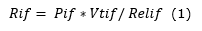
Although it is not the area with the highest percentage of surface covered with combustible material, its high susceptibility to water stress, the human factor and the proximity of vegetation susceptible to fire to road networks and roads, make this the territory where the highest number of fires occur annually (Figure 1).
 Source: Provincial Ranger Corps (2020)
Fig. 1. - Forest fires in the municipality of Holguín, 2003-2020
The relief of the municipality is slightly undulating and hilly and is located in peri-urban areas, creating an interface zone in which 5 of the 11 Popular Councils that make up the municipality are located. Brown, reddish, stony and rocky soils of shallow depth and very little moisture retention predominate (CITMA-Holguín, 2013).
The wind is generally from the northeast, reaching average annual speeds of 11.9 km/h, although sometimes varies from south to south-east. In the months of January to May the average speed is 14 to 17. 9 km/h, while the relative humidity has its lowest values from January to May (55 to 65 %) coinciding with the less rainy period and the average annual temperature varies between 22 and 27,50 C (CITMA-Holguín, 2013).
Rainfall averages 35 to 149 mm per year, with a rainy period from June to October and a less rainy period from November to May. In the latter the average rainfall reaches only 35 to 142.4 mm (CITMA-Holguín, 2013).
An analysis of the causes of forest fires in the head municipality in the last five years reveals that in all cases they are linked to human action. The one related to industrial activity associated with the characteristics of the context stands out (Figure 2).

In this context, the area called Colinas Verdes stands out, in which 11 settlements are located, among them the locality Matamoros-Oscar Lucero belonging to the Edecio Pérez Popular Council. In this area in the period 2012-2015, 18 fires occurred with losses amounting to 107 100 CUP, being those of 2015 the ones that caused the greatest environmental impacts to the detriment of 80.52 ha of natural forests, which represent 30 % of the municipal total. For these reasons, it is considered a high priority zone for the attention of the Holguín Municipality Forest Ranger Corps.
According to the socio-environmental diagnosis carried out in the APAR project, the Oscar Lucero community is located in a facility that belonged to a military regiment built in 1940. In 1990, after a hurricane hit the province, it began to house affected families, and in 2000 it was decided to make it a community until the present day. It is located on the banks of the Matamoros River, in the exact place where it crosses under the central highway, about six kilometers from the center of the city of Holguín. It is composed by 1 734 inhabitants located in 254 houses, twenty of them in very bad constructive state located in the marginal neighborhood "El Dique".
The settled population is basically of mixed origin (57 % rural and 43 % urban), about 60 % have been in the area for less than 30 years and only 33 % were born in the area. The study carried out to find out the origins of the migration flows that make up the community shows that more than half of the families have been in the area for between 10 and 20 years. Approximately 60 % of the population works or studies, 17 % of the women are housewives, one fifth are retired or unemployed.
The access to self-employment is limited because the community has low economic resources to undertake these activities, also negatively impacted by the distance from the sources of resources and raw materials for the maintenance of these businesses. The educational level is average, only 63 % of the population has completed secondary school and only 15 % of the population has completed university studies.
For the community, the Matamoros River is a symbol and a natural resource with which they identify. Several religions are practiced; the most significant are those of the Protestant denominations, Spiritualism and to a lesser extent Catholics. There are concerns for the practice of various artistic manifestations, mainly for singing and dancing, which are encouraged from the Cultural Headquarters.
Among the main social problems are: poor mobility, few recreational spaces, presence of alcoholism and insufficient communication (only one agent center, six private telephones TFA, few cell phones). In El Dique there is no means of communication, and only the doctor's office, the PNR and the school have telephones.
From the geological point of view, the area is dominated by serpentinite rocks (serpentinized ultramafics) of the Yaguajay formation, which constitutes a chaotic complex with serpentine blocks, gabbros and limestones.
The hydrology is given by a well-developed drainage network, whose main current is constituted by the Matamoros river, that is born approximately in the coordinates North: 250.650 and East: 259.300, at an altitude of 180 m a.s.l, on serpentinite rocks; it is a permanent current that has a predominant direction from North to South. The Matamoros river basin, which is the most important in the municipality of Holguín, is a sub-account of the Cauto basin, considered by the National Council of Hydrographic Basins as one of the ten basins of national interest, due to its natural values and importance in the economic, social and environmental fields. The bed is made up of sandy and clayey materials of serpentinite origin. The average height of the basin is 129 meters above sea level, the slope of the river is 3.52° and a length up to the closure of the dam is 14.9 km.
The average hyperannual runoff is of the order of 16.9 hm³ until the closing of the Güirabo dam, which regulates the runoff. The annual distribution of the runoff is in correspondence with the typical characteristics of the territory, with a dry season from November to April and a wet season from May to October.
The soil belongs to the typical brownish red ferromagnesial fersialitic type on ultrabasic rock, saturated, shallow, moderately humified; of medium erosion, clayey, of strong graveliness, excessively stony. The effective depth is 14 cm and it is undulating. Limiting factors include effective depth, gravel content and slope. This type of soil is very infertile and therefore not suitable for agriculture due to its low content of essential nutrients. The agro-productive category is IV with vocation for pastures and forest plantations.
In the APAR project, another study conducted by the Centro de Investigaciones y Servicios Ambientales y Tecnológicos de Holguín (CISAT, 2016) distinguished three types of plant formations: secondary grassland of the Matamoros river and streams; thorny xeromorphic scrub on serpentinites (cuabal) and semi-anthropic savannah.
The secondary grassland on the banks of rivers and streams is located on the margins of the fluvial current, it is possible to observe some relict trees of the old vegetation formation of the gallery forest such as Bucida buceras, Lonchocarpus sericeus and Andira cubensis , which coexist with invasive exotic species that were established after the degradation of the site, Lonchocarpus sericeus and Andira cubensis, which coexist with invasive exotic species, such as Pithecellobium dulce and Schinus terebinthifolius, which were established after the site was degraded.
The physiognomy of the vegetation is defined by the dominance of the herbaceous stratum, which reaches 100 % coverage. Due to the small size of the water mirror, the zonation typical of lentic habitats is not observed. However, from the center of the water body to the limit of the influence of humidity the floristic composition changes.
The thorny xeromorphic scrub on serpentinites constitutes a relict of natural vegetation on serpentine substrates, characterized by high species richness and high plant endemism. It is established on hills with slopes between 5° and 7° to the north of the Oscar Lucero neighborhood. The soils are of the ferromagnesial red-brownish ferromagnesial type, derived from the serpentinites of the Yaguajay formation. The rocky coverage is 15 to 95 % and the pH slightly acid, from 6 to 6. These soils are very poor in essential nutrients and rich in heavy metals toxic to plants, which together with the low capacity to retain water determine that this vegetation has a marked xeromorphic character. The xeromorphism is evident in the dominance of microphilous, thorny species with very leathery leaves.
The vegetation has a very compact structure. The shrub layer varies between 1.5 to 3.5 m in height, with a coverage of 75 % and 90 %. The high variability in the coverage is given by the presence of clearings in the bush at irregular intervals. There are emergent trees up to 5 m high, belonging to the species Spirotecoma holguinensis and Pisonia rotundata. The shrub stratum has a high species richness, which varies between 5 and 15 species in 4 m2 and 56 % to 76 % of endemism. Among the most common species are: Bourreria divaricata, Guettarda shaferii, Oplonia multigemma, Pictetia marginata, Coccoloba reflexa, Piscidia cubensis, Jacaranda cowelii and Coccothrinax garciana.
The herbaceous species are distributed in patches, without forming a continuous stratum. Small, cespitose or rosette-forming herbs abound, which is why the cover is very variable (5 to 35 %). The richness of strictly herbaceous species (excluding shrub seedlings and creeping climbers) varies between 1 and 6 species in 4 m2, with an average of 45 % endemism. It is common for some climbers to grow as creepers as part of the herbaceous layer. The most common species are: Scleria havanensis, Turnera sp., Evolvulus minimus, Crossopetalum aquifolium, Aristida refracta, Rhynchospora tenuis and Elytrariacubana. The climbers are abundant, particularly in sites with structural affectations caused by selective logging and on the edge of the patches. The specific richness ranges between 3 and 7 species in 4 m2, with 25 % endemism. Among the most abundant species are: Mesechites minimus (Apocynaceae), Galactiasavannarum (Fabaceae), Smilaxgracilior (Smilacaceae) and Stigmaphyllon sagranum. This type of vegetation is very poor in epiphytes. The semi-anthropic savanna is dominated by herbaceous species and constitutes an alternative stable stage of the thorny xeromorphic scrub vegetation on serpentinites (cuabal), which is implanted after the degradation of the natural vegetation, due to the low regenerative capacity of the shrub layer. The disturbances that gave rise to this secondary vegetation formation were inadequate forest management, recurrent fires and cattle grazing. In sites cleared to plant species of forest interest, alien to these ecosystems, the recovery of the shrub layer is very poor or almost nonexistent and the herbaceous layer is dominated by exotic species Bothriochloa pertusa, and in turn, are the most vulnerable area to fires.
In this space the shrubs do not form a continuous stratum, but are distributed in patches of variable extension. The height of the shrub stratum is very variable, with values ranging from 1 to 5 m. Among the shrub species typical of the original vegetation that tend to persist are: Bourreria divaricata, Ateleia cubensis, Byrsonima crassifolia, Varronia grisebachii, Pictetia marginata, Diospyros crassinervis, Coccoloba reflexa and Pisonia rotundata.
The herbaceous stratum defines the physiognomy of the vegetation and is organized in two sub-strata, with a height ranging between 0.4 and 0.6 m. On the other hand, the herbaceous cover increases once the original vegetation is degraded, which is one of the strongest signs of structural affectation, which reduces the regenerative capacity of the shrub layer and increases the sensitivity to fires. These combined factors contribute to the maintenance of savanna ecosystems.
Determining the dimensions and components of local resilience
In previous studies carried out by the authors of this study, elements of local resilience were defined as socio-ecological robustness (given in the density and centrality of social and environmental networks) and specific resilience. The latter is composed of sociocultural, environmental, economic, structural, technological and governance resilience.
The variables selected in each dimension, some of the authors consulted and the statistics obtained are shown in (Singh-Peterson & Underhill, 2017; Flores y Sanhueza, 2018; Cotroneo et al.,2018; Van der Merwe et al., 2018; Sakai et al., 2019), (Twigg, 2009; Cutter et al., 2008; Henao, 2013; Davidson et al.,2016; GOAL, 2015; Sellberg et al., 2018 (Table 1).
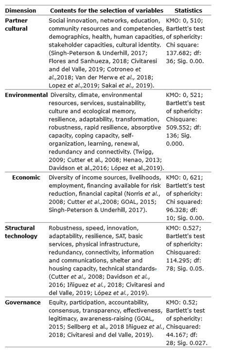
When the centrality study was carried out, the variables that characterize local resilience were identified (Figure 3).
Fig. 3. - Centrality analysis of the resilience variables a) socio-cultural, b) environmental, c) structural-technological, d) economic and e) governance
Where:
Socio-cultural resilience: Social innovation (INS); community resources (RCOM) and cultural resources (RCUL).
Environmental resilience: ecological diversity (DIV); absorptive capacity (CAB) and adaptability (ADA)
Economic resilience: sources of income (FIN); livelihoods (MDV).
Structural-technological resilience: speed (RAP); physical capabilities (CAPFIS) and technological innovation (INNOV).
Governance Resilience: Participation (PART); Government Accountability (RESP) and Effective Management (EEF).
For the assessment of specific resilience, a checklist of 38 items was designed (Appendix 1) and validated by expert judgement. Eighteen experts participated and the reliability of the instrument was demonstrated with a Cronbrach's Alpha of 0.996. The Kendall's concordance coefficient obtained was 0.887.
Local resilience and risk assessment
Based on the results obtained in 2016, a community forest fire risk management plan was designed and implemented over a five-year period, which corroborated the increase in the number of forest fires Relif (Table 2).

The main activities were aimed at raising social perception and innovation, through the processes of social knowledge and its socialization, self-organization and the increase of cultural potential. They included actions for habitat conservation and biodiversity rehabilitation, promoting access to water and enhancing the induced regeneration of flora. In the economic dimension, it was proposed to promote capacities for entrepreneurship and to mobilize aid, through the management of community and institutional projects, and with it the knowledge of the sources of financing and the tools of rational negotiation. In terms of technology, to consolidate community early warning systems and coping capacities; and in terms of governance, to strengthen citizen participation through the processes of consultation, consensus-building, social responsibility and to promote compliance with the risk reduction plan.
In the elevation of socio-ecological robustness it was important to increase community leadership (in this case, polycentric) in coincidence with GOAL (2015) and the articulation of social actors as proposed in Sellberg et al., (2018) which allowed to raise the density of the social network and reduce its centrality.
In relation to specific resilience, the greatest growth in the sociocultural dimension is similar to that obtained in Cutter et al., (2008) in six of the ten communities studied by these authors. Where it was significant the elevation of social knowledge and innovation as in GOAL (2015), and of community capitals unlike what was detected by Cutter et al., (2008). In the environmental aspect, the absorption capacity and adaptability grew largely due to the management of water resources and the production of seeds with native species, similar to the results of Henao (2013).
Economic resilience was the least developed as opposed to that identified by Cutter et al., (2008) in Marshall County, and increased access to markets and financial services as achieved in GOAL (2015). In structural-technological community response speed was highest as an expression of practices in the face of hazard, as in GOAL (2015). In governance resilience, the contribution of citizen participation and planning was important in its contribution to the elevation of risk management effectiveness, similar to Sellberg et al., (2018).
Figure 4 shows the number of fires and areas affected annually from 2012 to 2019. The comparison of the results obtained in the interval 2012-2015, with the period of implementation of the management plan from 2016 to the end of 2019 (shaded area), allows identifying a reduction in the number of fires (ten less) and the affected area by 69.6 ha (Figure 4). The quantified economic losses decreased from 105 342.08 to 15238.98 CUP in the interval 2016-2019.
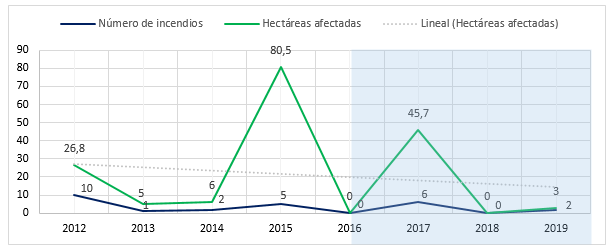 Source: Hernández (2020)
Fig. 4. - Behavior of forest fires in the Oscar Lucero-Matamoros area, 2012-2019
On the other hand, the analysis of the linear regression model of the results showed that 82.4% of the variation observed in the dependent variable (risk) is explained by the predictor variable (resilience), with a significance value of change F 0.021<0.05. The analysis of variances confirms with a significance level of 0.004 that the means observed in each year are significantly different, which demonstrates the effectiveness of the approach assumed by the authors.
CONCLUSIONS
The characterization of the risk scenario that takes into account socio-natural elements provided the elements required to identify not only the vulnerability and hazard assessment, but also the components of social robustness associated with the density and centrality of the network of actors, and ecological robustness.
The dimensions, variables and indicators proposed for determining the Relif The dimensions, variables and indicators proposed to determine the risk management plan are pertinent and adequate for its practical application, through the evaluation of the checklist elaborated and the use of the statistical methods used. The implementation of the community risk management plan, based on these findings, made it possible to raise the Relif and reduce the risk of forest fires in the locality.
ANNEX
Annex 1. Specific resilience assessment:
Does the locality have a good innovative potential?
Do people have social knowledge about wildfires and their risks?
Does the locality develop processes of socialization of knowledge about forest fires and their risks?
Does the locality show collective learning about wildfires and their risks?
Does the locality have public health resources for wildfire risk reduction?
Does the locality have educational resources for wildfire risk reduction?
Do self-organised processes take place in the locality?
Does collective self-esteem exist in the locality?
Does the locality have a cultural identity?
Does the locality have a cultural potential that contributes to wildfire risk reduction?
Is the diversity of biomes counted and known?
Is landscape diversity available?
Does the ecosystem exhibit habitat diversity?
Are ecosystem protection measures in place?
Are natural and artificial water sources available?
Does natural regeneration of species develop after forest fires?
Are actions carried out that favour induced regeneration?
Does the population have wage resources?
Does the population have access to credit and insurance against forest fires?
Does the locality have the capacity to mobilize financial support and resources from outside?
Do people in the locality have assets that generate income?
Do people in the locality offer services that generate income?
Have extinguishing access routes been established and maintained?
Do you have evacuation and shelter capacities for affected people?
Is there technological infrastructure available to the villagers?
Are the dwellings and infrastructure built with fire-resistant materials?
Are monitoring and early warning systems in place?
Are FI risk reduction tools and equipment available?
Are socio-economic goods and services affected by FIs recovered?
Are local actors mobilized and is citizen participation good?
Does the locality develop information processes on government decisions and risk reduction by FIs?
Is the population consulted on government and FI risk reduction decisions?
Are concertation processes carried out among local stakeholders for governmental decision-making and FI risk reduction?
Are FI risk reduction actions included in local government management?
Is socio-environmental responsibility practiced in local public and private entities?
Are the actions and requirements of the land-use plan for the locality fulfilled?
Are the actions in the FI risk reduction plan being met?
REFERENCIAS BIBLIOGRÁFICAS
ALVARADO, M., 2019. Prevención de incendios forestales. 2019. S.l.: s.n. [ Links ]
BRIONES-HERRERA, C.I., VEGA-NIEVA, D.J., MONJARÁS-VEGA, N.A., FLORES-MEDINA, F., LOPEZ-SERRANO, P.M., CORRAL-RIVAS, J.J., CARRILLO-PARRA, A., PULGARIN-GÁMIZ, M.Á., ALVARADO-CELESTINO, E., GONZÁLEZ-CABÁN, A., ARELLANO-PÉREZ, S., ÁLVAREZ-GONZÁLEZ, J.G., RUIZ-GONZÁLEZ, A.D. y JOLLY, W.M., 2019. Modeling and Mapping Forest Fire Occurrence from Aboveground Carbon Density in Mexico. Forests [en línea], vol. 10, no. 5, pp. 402. [Consulta27/05/2021]. DOI 10.3390/f10050402. Disponible en: Disponible en: https://www.mdpi.com/1999-4907/10/5/402 [ Links ]
CALDERÓN, J.C., 2021. Apreciación de los incendios forestales en Holguín. Informe a la Jefatura de Guardabosques. Holguín, Cuba. [ Links ]
CENTRO DE INVESTIGACIONES Y SERVICIOS AMBIENTALES Y TECNOLÓGICOS [CISAT]., 2016Diagnóstico Ambiental en los Consejos Populares Pedernales y Edecio Pérez 2016. Holguín, Cuba: Informe proyecto APAR. [ Links ]
CITMA, 2013. Estudios de PVR de incendios rurales. Holguín, Cuba: Departamento de Investigación y Desarrollo, Centro Provincial de Meteorología de Holguín. [ Links ]
COTRONEO, S.M., JACOBO, E.J., BRASSIOLO, M.M. y GOLLUSCIO, R.A., 2018. Restoration ability of seasonal exclosures under different woodland degradation stages in semiarid Chaco rangelands of Argentina. Journal of Arid Environments [en línea], vol. 158, pp. 28-34. [Consulta: 27/05/2021]. ISSN 0140-1963. DOI 10.1016/j.jaridenv.2018.08.002. Disponible en: Disponible en: https://www.sciencedirect.com/science/article/pii/S0140196318309698 . [ Links ]
CUTTER, S.L., BARNES, L., BERRY, M., BURTON, C., EVANS, E., TATE, E. y WEBB, J., 2008. A place-based model for understanding community resilience to natural disasters. Global Environmental Change [en línea], vol. 18, no. 4, pp. 598-606. [Consulta: 27/05/2021]. ISSN 0959-3780. DOI 10.1016/j.gloenvcha.2008.07.013. Disponible en: Disponible en: https://www.sciencedirect.com/science/article/pii/S0959378008000666 . [ Links ]
DAVIDSON, J., JACOBSON, C., LYTH, A., DEDEKORKUT-HOWES, A., BALDWIN, C., ELLISON, J., HOLBROOK, N., HOWES, M., SERRAO-NEUMANN, S., SINGH-PETERSON, L. y SMITH, T., 2016. Interrogating resilience: toward a typology to improve its operationalization. Ecology and Society [en línea], vol. 21, no. 2. [Consulta: 27/05/2021]. ISSN 1708-3087. DOI 10.5751/ES-08450-210227. Disponible en: Disponible en: http://www.ecologyandsociety.org/vol21/iss2/art27/ . [ Links ]
FAO., 2019. Conjunto de Herramientas para la Gestión Forestal Sostenible. Gestión de incendios de vegetación [en línea]. 2019. S.l.: FAO. [Consulta: 08/01/2020]. Disponible en: Disponible en: http//www.fao.org/sustainable-forest-management/toolbox/modules/vegetation-fire-management/basic-knowledge/es . [ Links ]
FLORES CISTERNAS, P.T. y SANHUEZA CONTRERAS, R.A., 2018. Community Resilience in the face of Natural Disasters: Caleta Tumbes, Biobío Region of Chile. Cuadernos de Geografía: Revista Colombiana de Geografía [en línea], vol. 27, no. 1, pp. 131-145. [Consulta: 27/05/2021]. ISSN 0121-215X. DOI 10.15446/rcdg.v27n1.59904. Disponible en: Disponible en: http://www.scielo.org.co/scielo.php?script=sci_abstract&pid=S0121-215X2018000100131&lng=en&nrm=iso&tlng=es . [ Links ]
HARDY, V., GALLARDO, O.Y. y FORNET, E., 2014. El enfoque de recursos y capacidades en la gestión local del riesgo por amenazas naturales. Anuario del seminario de postgraduación. [en línea]. Brasil: Universidad de Feevale. Disponible en: http//www.feevale.br/hotsites/spg/edicao-actual. [ Links ]
HERNÁNDEZ, L., 2020. El planeta en llamas. Propuesta ibérica de WWF para la prevención de incendio [en línea]. 2020. S.l.: Edición WWF España y ANP|WWF. Disponible en: https://wwfes.awsassets.panda.org/downloads/wwf_informe_incendios_2020_el_planeta_en_llamas.pdf. [ Links ]
HERNÁNDEZ, Y., 2020. Estudio del área a proteger por el circuito Colinas Verdes para la toma de decisiones. 2020. S.l.: Jefatura Provincial Cuerpo Guardabosques Holguín. Ministerio del Interior de la República de Cuba. [ Links ]
ORGANIZACIÓN HUMANITARIA INTERNACIONAL [GOAL], 2015. Herramienta para medir la resiliencia Comunitaria ante desastres. Guía metodológica. [en línea]. 2015. S.l.: ORGANIZACIÓN HUMANITARIA INTERNACIONAL [GOAL]. [Consulta: 18/04/2016]. Disponible enDisponible en: https://www.goalglobal.org . [ Links ]
ORGANIZACIÓN MUNDIAL DE LA SALUD [OMS]., 2019. Incendios forestales. Hoja de datos técnicos sobre peligros. Características de los desastres naturales [en línea]. 2019. S.l.: ORGANIZACIÓN MUNDIAL DE LA SALUD [OMS]. [Consulta: 19/02/2020]. Disponible en: Disponible en: https//www.who.int/hac/es/ . [ Links ]
PEREIRA TORRES, F.T., BATALHA ROQUE, M.P., SOUZA LIMA, G., VENÂNCIO MARTINS, S. y FARIA, A.L.L. de, 2017. Mapeamento do Risco de Incêndios Florestais Utilizando Técnicas de Geoprocessamento. Floresta e Ambiente [en línea], vol. 24. [Consulta: 27/05/2021]. ISSN 2179-8087, DOI 10.1590/2179-8087.025615. Disponible en: Disponible en: http://www.scielo.br/j/floram/a/PTZgzwgsGYRPZf4S4pSCZqn/abstract/?lang=pt . [ Links ]
SAKAI, P., CABALLERO, N., SAKAI, M., AQUINO, C., OREGGIONI, F., LOPEZ, L., OBERLING, D., SCHNEIDER, T., FRANZINI DE SOUZA, A.C., y TISCHNER, A., 2018. Vulnerabilidad climática de Puerto Iguazú, Argentina: Camino hacia la adaptación. Medio Ambiente y Urbanización [ en línea], vol. 88, pp. 63-94. Disponible en: https://www.researchgate.net/publication/326068686_Vulnerabilidad_climatica_de_Puerto_Iguazu_Argentina_Camino_hacia_la_adaptacion. [ Links ]
SALAZAR, A.H., 2013. Propuesta metodológica de medición de la resiliencia agroecológica en sistemas socio-ecológicos: Un estudio de caso en los Andes Colombianos. Agroecología [en línea], vol. 8, no. 1, pp. 85-91. [Consulta: 27/05/2021]. ISSN 1989-4686. Disponible en: Disponible en: https://revistas.um.es/agroecologia/article/view/183031 . [ Links ]
SANDOVAL D., B., REYES R., T., OYARZÚN G., M., SANDOVAL D., B., REYES R., T. y OYARZÚN G., M., 2019. Mecanismos de los efectos nocivos para la salud de la contaminación atmosférica proveniente de incendios forestales. Revista chilena de enfermedades respiratorias [en línea], vol. 35, no. 1, pp. 49-57. [Consulta: 27/05/2021]. ISSN 0717-7348. DOI 10.4067/S0717-73482019000100049. Disponible en: Disponible en: http://www.scielo.cl/scielo.php?script=sci_abstract&pid=S0717-73482019000100049&lng=es&nrm=iso&tlng=es . [ Links ]
SECRETARIA DEL CONSEJO DE MINISTROS DE LA REPÚBLICA DE CUBA, 2018. ESTRATEGIA Y PROGRAMA NACIONAL DE GESTIÓN MANEJO DEL FUEGO EN LOS BOSQUES DE LA REPÚBLICA DE CUBA [EPNMF]. . Cuba: Secretaria del Consejo de Ministros de la República de Cuba. [ Links ]
SELLBERG, M.M., RYAN, P., BORGSTRÖM, S.T., NORSTRÖM, A.V. y PETERSON, G.D., 2018. From resilience thinking to Resilience Planning: Lessons from practice. Journal of Environmental Management [en línea], vol. 217, pp. 906-918. [Consulta: 27/05/2021]. ISSN 0301-4797. DOI 10.1016/j.jenvman.2018.04.012. Disponible en: Disponible en: https://www.sciencedirect.com/science/article/pii/S0301479718303888 . [ Links ]
SINGH-PETERSON, L. y UNDERHILL, S.J.R., 2017. A multi-scalar, mixed methods framework for assessing rural communities' capacity for resilience, adaptation, and transformation. Community Development [en línea], vol. 48, no. 1, pp. 124-140. [Consulta: 27/05/2021]. ISSN 1557-5330. DOI 10.1080/15575330.2016.1250103. Disponible en: Disponible en: https://doi.org/10.1080/15575330.2016.1250103 . [ Links ]
TWIGG, J., 2009. Características de una Comunidad Resiliente ante los Desastres [en línea]. 2009. S.l.: s.n. [Consulta: 18/04/2016]. Disponible en: Disponible en: http//www.benfieldhrc.org/disaster_studies/projects/communitydrrindicators/community_drr_indicators_index.htm . [ Links ]
VAN DER MERWE, S., BIGGS, R. y PREISER, R., 2018. A framework for conceptualizing and assessing the resilience of essential services produced by socio-technical systems. Ecology and Society [en línea], vol. 23, no. 2. [Consulta: 27/05/2021]. ISSN 1708-3087. DOI 10.5751/ES-09623-230212. Disponible en: Disponible en: https://www.ecologyandsociety.org/vol23/iss2/art12/ . [ Links ]
VAN DER WERF, G.R., RANDERSON, J.T., GIGLIO, L., VAN LEEUWEN, T.T., CHEN, Y., ROGERS, B.M., MU, M., VAN MARLE, M.J.E., MORTON, D.C., COLLATZ, G.J., YOKELSON, R.J. y KASIBHATLA, P.S., 2017. Global fire emissions estimates during 1997-2016. Earth System Science Data [en línea], vol. 9, no. 2, pp. 697-720. [Consulta: 27/05/2021]. ISSN 1866-3508. DOI 10.5194/essd-9-697-2017. Disponible en: Disponible en: https://essd.copernicus.org/articles/9/697/2017/ . [ Links ]
Received: March 20, 2021; Accepted: June 02, 2021

