


 Servicios personalizados
 texto en
  Inglés (pdf)
 Articulo en XML
 Referencias del artículo
 Enviar articulo por email
 Citado por SciELO
  Similares en
SciELO
Similares en
SciELO 
 Permalink
INTRODUCTION
For planning Crops Irrigation Scheduling with precision it is necessary to develop studies and integrate the information related to the behavior of the climatic variables (Precipitation and Evaporation), the water needs of the crops (Evapotranspiration) and the depth of the roots during their life cycle, as well as the behavior of the hydrophysical properties of soils (Water Holding Capacity, Bulk density, Porosity and Infiltration rate).
Some authors have made studies for finding relationships between some easy to measure soils hydrophysical properties in order to estimate the difficult ones. However, Morales and Viloria (2007), demonstrate in their reliability study of the so-called "pedotransference functions" to predict water retention in soils, that none of these models adequately predict the water content retained at -33 kPa and - 1500 kPa.
The use of soil moisture sensors has been another resource used to plan and execute irrigation according to the water availability for crops. However, Raper et al. (2015), concluded a study focused on determining the response of two low-cost sensors to changes in soil moisture and soil texture.
In this study, they demonstrate that these measurements are very sensitive to changes in texture and moisture that can occur in a very restricted volume of soil where these devices have their reach, so they warn that soil variability is one of the most important elements to consider for the implementation of these sensors.
Cantú, cited by Prieto et al. (2013), considers a group of Soil Quality Indicators (SQI) to assess the impact of the change of land use and management. Among the factors to consider are included pH, Organic Carbon, Bulk Density and Infiltration Rate.
The previous result is complemented by the results of Hernández et al. (2017),who demonstrate that some soil properties may change over time due to the change in land use.
In Manabí Province in Ecuador, several studies have been carried out focused on the behavior of the physical-chemical properties of soils in areas of agricultural interest. One of the most interesting and recent results is obtained by Carrera et al. (2017). In its physical-chemical characterization from the agricultural point of view of the soils, in the irrigation area of Chone Multipurpose Project. This work is extended with the study developed by Pérez et al. (2018a), who published results of hydrophysical properties of soils for irrigation purposes in Chone. Nevertheless, these results, the available information is still insufficient for planning crop irrigation schedule throughout the Province on the basis of the hydrophysical properties of soils.
The results presented in this investigation have been generated from a Research Project developed by Universidad Laica Eloy Alfaro de Manabí that aims to develop a study of edaphoclimatic conditions in Manabí for the design and operation of irrigation systems. This work is a complement to the climatological study developed for the province of Manabí in Ecuador by Pérez et al. (2018b). The justification for the study is based on the ¨lack of processed information¨, which has been one of the problems related to irrigation identified by MAGAP (2012), for the Ecuadorian Coast Region. For this reason, the objective of this work is to determine the hydrophysical properties of soils in three areas of agricultural interest in Manabí with the purpose of planning the irrigation of crops of economic and social interest.
METHODS
For the development of this study, three zones of agro-productive interest were selected in the Manabí province: North Zone of Chone Canton, San Ramón in Sucre Canton and Mapasingue in Portoviejo Canton. A more detailed information of the three zones of study as well as the coordinates of the 14 points where the hydrophysical properties of the soil were determined can be seen in Figure 1.
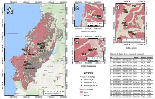
FIGURE 1 Location of the three study areas and coordinates of the 14 points analyzed in the province of Manabí. (Source: Elaboration of the Authors).
Determination of Hydrophysical Properties of the Soil
Tests were carried out to determine field capacity, real density, bulk density, soil porosity and infiltration rate. The procedure to determine each of the hydrophysical properties is described below:
Field Capacity: It was determined by the floodplain method. The soil samples were taken after 72 hours of saturation once considered that soils were of fine and medium texture. Three samples were taken for each horizon of 10 cm thick from the surface to 50 cm deep (5 depths: 0-10 cm, 10-20 cm, 20-30 cm, 30-40 cm and 40-50 cm). That generates a total of 15 soil samples. This operation was carried out for a replica on the same platform, which generated a total of 30 samples (two perforations with 15 samples in each perforation as shown in Figure 2).
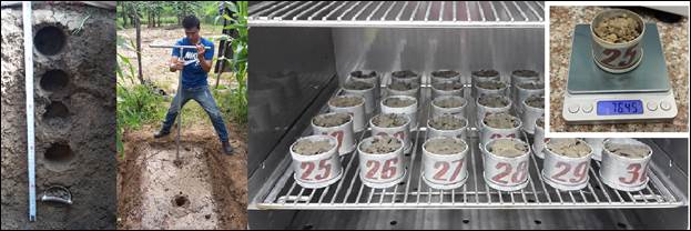
FIGURE 2 Sample extraction and processing in the laboratory for the determination of field capacity, real density, bulk density and porosity.
Real Density, Bulk Density and Porosity: They were determined from samples taken in a test pit made in the soil at each of the 14 study points (first image of Figure 2) and processed in the laboratory according to the provisions of ISO 11272: 2017 (ISO 11272, 2017).
Infiltration Rate: It was determined by the double ring Infiltrometer method described by CIMMYT (2013). This technique is one of the most used because of its low complexity, compared to the other forms of evaluation. It consists of penetrating the ground with two metal rings placed concentrically. The rings can have a height of 30 to 40 cm and diameters of 30 to 40 cm (the inner cylinder) and 50 to 60 cm the outer cylinder. Water is simultaneously supplied in both cylinders and measurements of the water levels in the inner cylinder are started by means of a ruler with a float placed on top. A record of infiltrated levels and water supplies is made to maintain stable levels in both cylinders over time (Figure 3). The measurements end when there is evidence of a stable infiltration over time. The mathematical expression described by Kostiakov-Lewis and cited by Landini et al. (2017) was used.

RESULTS AND DISCUSSION
Field Capacity Behavior
Figure 4 shows the behavior of the field capacity in the three study areas. Figure 4-A shows how the field capacity behaved in the eight points analyzed in Chone. A stability of this parameter is evident up to 20 cm deep, where values ranging between 32 and 43% of dry soil weight (pss) are obtained. From the 30 cm of depth, a greater dispersion of these results takes place, those are in the range of 15 to 55% pss. A pending aspect to analyze in future studies of this property should be oriented to the effect of man in the soil moisture retention alterations associated with the change in land use (Daza et al., 2014). The highest stability of this parameter in the entire soil profile was observed in San Ramón (Figure 4-B) and Mapasingue (Figure 4-C) zones. The average value of field capacity obtained in Chone was 37.43% pss, while for San Ramón an average of 37.06% pps was obtained and for Mapasingue it was 34.51% pss.

Real Density Behavior
The behavior of the real density in all the points is summarized in Figure 5. As a consequence of irregularities during the processing in the laboratory, the sample of point MP-1 is omitted.
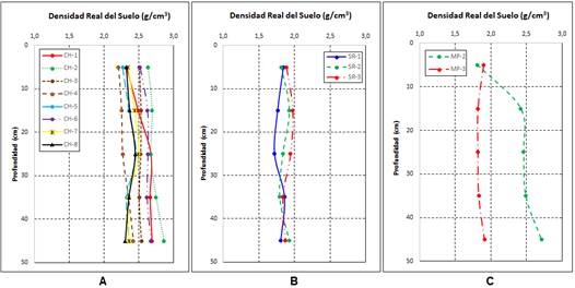
FIGURE 5 Behavior of the real density in the three study areas: A- Chone, B- San Ramón and C- Mapasingue.
The real density obtained in the soils of Chone (Figure 5-A) is slightly higher than that the ones in San Ramón and Mapasingue (Figures 5-B and 5-C). In all cases, these values were quite stable with the increase in depth. The average value of the real density obtained in Chone was 2.48 g/cm3, while for San Ramón an average of 1.85 g/cm3 was obtained and for Mapasingue it was 2.12 g/cm3. These results contrast with those obtained by Volverás et al. (2016) who observed a decrease in this property with depth.
Bulk Density Behavior
The bulk density behaved according to what is reflected in Figure 6. As a consequence of irregularities during the processing in the laboratory, the samples of the CH-3 and MP-1 points are omitted.
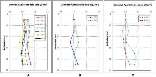
FIGURE 6 Behavior of Bulk density in the three study areas: A- Chone, B- San Ramón and C- Mapasingue.
In Figure 6-A, it is observed that the bulk density obtained in the soils of Chone is also slightly higher that the ones in San Ramón and Mapasingue (Figures 6-B and 6-C). In all cases, these values were quite stable with the increase in depth. The average value of the bulk density obtained in Chone was 1.12 g/cm3, while for San Ramón an average of 1.05 g/cm3 was obtained and for Mapasingue it was 1.09 g/cm3.
According to the evaluation of this parameter obtained by Cairo (2003)1, these values are classified as "low" since they are between 1 and 1.2 g/cm3. They also correspond to the declared range of this parameter for clay-textured soils, according to the Secretaría de Medio Ambiente y Recursos Naturales de México (2002), where a range of 1 to 1.19 g/cm3 is established for this soil texture.
Porosity Behavior
Figure 7 shows the behavior of porosity by strata up to 50 cm deep. Figure 7-A shows that the highest porosity was obtained in Chone soils, varying from 49 to 55% with an average value of 52.32%. Figures 7-B and 7-C show the values of porosity in San Ramón and Mapasingue, with average values of 42.59% and 48.05%, respectively.
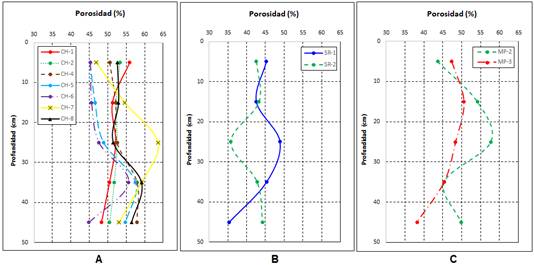
An important aspect that should be considered for evaluating soil porosity is the effect of tillage systems (Leyva et al., 2014), associated with the use of land. It keeps a close relationship with the infiltration rate and should be evaluated in each zone for future studies.
Infiltration Rate Behavior
Figure 8 shows the behavior of the Accumulated Infiltration Rate in the 14 points that were evaluated. As shown in Figure 8-A, in Chone, there are two types of soils differentiated by their infiltration rate. Points CH-5 and CH-6 show infiltration rates of less than 20 mm/min. This behavior contrasts with the infiltration rates that were obtained in the six remaining points in Chone, where infiltration rates are reached at the start of the tests between 45 and 100 mm/min. An interesting aspect results from observing that these same points were the ones with the lowest porosity value obtained in the first strata in Chone (Figure 7-A). The San Ramón and Mapasingue soils also showed very low infiltration rates that do not exceed 10 mm / min at the beginning of the tests and then stabilize at lower values.
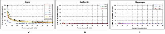
FIGURE 8 Cumulative Infiltration rate behavior in the three study areas: A- Chone, B- San Ramón and C- Mapasingue.
The infiltration rate stabilized at 60 minutes of testing at the low speed points in Chone did not exceed 1.5 mm/min. In the same period of time, in San Ramón and Mapasingue, values very close to the previous ones were reached without exceeding 2.5 mm/min infiltration rate. Although it was not an objective of this study to analyze the texture-infiltration linkage, little relationship between these properties was observed. That coincides with the results obtained by Hernández et al. (2017) and Landini et al. (2017). The latter concluded that "The differences observed in the infiltration rates would be attributed, beyond the classification of the soil, to other factors such as the use of the land and the influence of the animal load".
These results are of vital importance if it is intended to irrigate these areas with sprinkler irrigation systems since it is necessary to ensure that the intensity of water application does not exceed the infiltration rate in these soils.
CONCLUSIONS
The average value of Field Capacity obtained in Chone was 37.43% pss, very close to the value obtained in San Ramón (37.06% pss), unlike Mapasingue where only 34.51% pss was achieved.
The average Real Density obtained in Chone was 2.48 g/cm3, while for San Ramón, an average of 1.85 g/cm3 was obtained and for Mapasingue, 2.12 g/cm3.
The average value of the Bulk Density obtained in Chone was 1.12 g/cm3, the lowest value was obtained in San Ramón with 1.05 g/cm3 and in Mapasingue, the value 1.09 g/cm3 was obtained.
The highest porosity was obtained in the soils of Chone and ranged between 49 and 55% with an average value of 52.32%. The average porosity values in San Ramón and Mapasingue were 42.59% and 48.05%, respectively.
It was detected that there are two types of soils well differentiated in their infiltration rate in Chone. The infiltration rate stabilized at 60 minutes of testing at the low speed points did not exceed 1.5 mm/min. In the same period of time, in San Ramón and Mapasingue, values very close to the previous ones were reached without exceeding the 2.5 mm/min infiltration rate. Another soil area in Chone reaches stabilized infiltration rates above 10 mm/min, which makes it feasible for sprinkler irrigation.

