


My SciELO
 Custom services
Services on Demand
Article
 text in
  English (pdf)
 Article in xml format
 Article references
 Send this article by e-mail
Indicators
-
 Cited by SciELO
Related links
-
 Similars in
SciELO
Similars in
SciELO
Share

 Permalink
Revista Cubana de Ciencias Forestales
On-line version ISSN 2310-3469
Rev cubana ciencias forestales vol.9 no.3 Pinar del Río Sept.-Dec. 2021 Epub Sep 09, 2021
Original article
Methodology for the zoning of biomass potential for energy purposes oriented to forestry enterprises. Case of La Palma agroforestry enterprise, Pinar del Río
1Dirección Forestal, Flora y Fauna Silvestres. Ministerio de la Agricultura de Cuba. Cuba.
2Cátedra UNESCO "Medio Ambiente y Desarrollo". Instituto Superior de Tecnologías y Ciencias Aplicadas, Universidad de La Habana. La Habana, Cuba.
3Centro de Gestión de la Información y Desarrollo de la Energía (CUBAENERGIA). La Habana, Cuba.
The use of forest biomass for energy production represents one of the current alternatives considered by the country for its energy development. However, not all the information on the real potential of this resource is available at the enterprise level, which limits the timely planning of its management and sustainable use. The present work contributes to solve this situation by developing a methodology for the zoning and evaluation of the potential of residual forest biomass for energy purposes at the enterprise level. This methodology integrates data, management restriction criteria, results of previous research and Geographic Information System tools, which allows processing, analyzing and updating information on forest areas and their energy potential, based on data generated by forest management. The validation of the methodology, in its three stages, is carried out in the agroforestry enterprise La Palma, province of Pinar del Río. Seventy-six percent of the areas with a viable harvesting index are determined, 54.27 % of which are classified as very high, 0.35 % as high and 12.14 % as medium, with an annual residual forest biomass potential of 82,048.94 tons and an energy potential of 22,205 tons of oil equivalent. Three zones of high potential for energy purposes are defined: north and south of the Unidad Empresarial de Base Viñales, and the southern part of La Jagua. The results of the validation of the methodology show its viability, relevance and novelty for the company's economic, environmental and social management.
Key words: Residual forest biomass; Management; Methodology; Energetic potential; zoning.
INTRODUCTION
Forest ecosystems are the most important source of lignocellulosic biomass in the world. In most cases they are valued primarily by the volume of biomass usable by industry. Thus, there is a real amount of biomass that is underestimated. Biomass has the potential to be an important current and future energy source. It can be transformed into solid, liquid or gaseous fuel to replace fossil fuels at low investment levels and high profitability (Guyat et al., 2019).
A recognized solution to this problem is to incorporate these forest residues into bioenergy value chains. The bioenergy chain, from forest biomass, has four main links: production of raw material; transformation processes of this main input into biofuel; biofuel with specific characteristics and properties; and finally the use of this biofuel to obtain bioenergy to provide different energy services (Curbelo, A. et al., 2020).
Although each link is key, the production of the main input determines the completion of the chain. This link is the focus of the work developed. With this information, the company can evaluate the options for extraction, handling, transport, transformation and the insertion of new products in the bioenergy chain, considering costs, income and environmental and social impacts.
The policies aimed at the country's energy development (Council of State, 2019), the new facilities for foreign investment and the principles aimed at promoting the use of forest biomass as a renewable source of energy, with different uses, including the production of electricity, set out in the national forest policy, open up alternatives for a greater and better use of forest resources.
Based on these conditions and taking into account the sustainable management of forest resources, the objective of this work is to develop a methodology to contribute to the planning, management and utilization of residual forest biomass, particularly for energy purposes, in order to strengthen the decision-making capacity of forest enterprises in Cuba. As part of the validation of the methodology, its application is exemplified in the La Palma Agroforestry Enterprise in the province of Pinar del Rio.
MATERIALS AND METHODS
The work carried out is based on the analysis of several methodologies used for the spatial distribution of residual forest biomass, including those carried out by Altamirano, A., et al., (2015), Estrada-Torres, D., et al., (2017), Villela-Suárez, JM. et al., (2018) and Hernández-Ramos, J et al., (2020), specifically for energy purposes. These methodologies coincide in the use of allometric equations, remote sensing and use of GIS, to obtain better results. They also include factors for the zoning of areas according, mainly, to the conditions and geographical distribution of biomass, accessibility and legal regulations for the use of the resource.
The methodology developed in this work introduces an index that quantifies the combined effect of restrictive management factors and indicates the feasibility of residual biomass extraction, based on the cartographic representation.
The main working tool used is the forest management plan at the tenure level. This tool is regulated by a group of forestry sector legislations preceded by Forestry Law No. 85.
The energy characterization is based on the calculation of the energy associated with the calorific value of the predominant forest species in each area. Taking into account the dependence of this magnitude on the humidity of the biomass and with the purpose of standardizing the results, the caloric value of each forest species at a humidity of 25 % is used as a reference. The energy of the forest biomass is finally expressed in units of tonnes of oil equivalent (ft) to facilitate comparison with other fuels.
In the case of spatial information processing, even considering that, in forest management, the SIFOMAP information gathering and analysis tool is used, associated to the free platform GVSIG software, QGIS software is used due to its advantages.
RESULTS AND DISCUSSION
The methodology developed incorporates three stages (Figure 1).
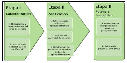
The following is an overview of the main features of the stages.
Stage I. Characterization
This stage constitutes the informative, legal and spatial basis necessary for the development of subsequent stages. It describes the physical-geographical and socioeconomic characteristics of the territory and incorporates management restriction criteria according to three main aspects: according to current legislation, morphological characteristics of the area and main accessibility infrastructure to the resource. Three restriction factors were defined for obtaining these areas: degree of slope (P) due to the marked geographical dependence of the biomass, road density (DC) according to accessibility to the resource and forest category (CB), as a regulatory framework for harvesting. These are not exclusive and can be added or modified when there are infrastructure improvements, technological changes or other interests of the tenant for the evaluation of their areas.
Stage II. Zoning
Geographical distribution zones are generated so that the tenure holder can, without committing violations, focus his activity on the places with the greatest potential for harvesting forest residues as a result of forest management. In order to quantify the effect of the combination of restrictive factors, the harvesting index (AIv) is introduced (Equation 1).

For its calculation, the restriction criteria are assigned values from one (minimum) to three (maximum) according to the real possibility of using the waste and according to established standards. It is used as assumptions in the formulation of this index that, when any of these criteria corresponds to situations that do not allow the use (value 1), then the exploitation of the area is not viable and the index is zero. These criteria may change depending on technological change, road infrastructure and the existence of forest biomass, which are mainly associated with company decisions, development projects in the territory and also meteorological phenomena. In addition, it is considered that all restrictions have equal weight. Thus, the harvesting index matrix is formed. In spatial form, each of the criteria can be represented, differentiating its value and finally showing a map of areas according to the utilization index (IAv), classified as Very High, High, Medium, Low and Not viable.
The equations incorporated for biomass calculation are derived from references made by Guyat et al., (2019), Vidal et al., (2001) , Rodríguez et al., (2018) and the biomass density based method determined by Brown, S. (1997), in which the biomass of the inventoried volume is calculated from the product of the volume and density of the species. Species density values used were taken from Guyat et al., 2019. Given the uncertainty in the realizations of the sanitary cuts, because they depend on external factors, they are not taken into account in obtaining these results.
Stage III. Estimation of energy potential
In this stage, the estimated residual biomass production potential is expressed in terms of its energy potential to replace petroleum-based fuels. For this purpose, the predominant species in each stand are characterized from the energy point of view, by their density and caloric power, assuming a moisture content of 25 %.
The calculation of the energy potential is based on the multiplication of the caloric power by the amount of residual biomass estimated in the minimum spatial unit (the stand), (Torres O, and Peña-Cortés, F. 2011). This energy potential is expressed in units of tons of oil equivalent (ft). In the case of the temporality with which the methodology is applied, it depends on the period to carry out the activities planned by the company, in the case of logging, the felling cycle established according to the age of the stand and likewise in the treatments, therefore, the calculations are made annually and the database is updated.
Pinar del Río, stands out for its high biomass potential, with an availability of 213.1 Mm3 at the end of 2015, (Guyat et al., 2019), is thus, one of the provinces with the greatest potential for biomass generation for energy purposes. It was considered relevant to validate the methodology in a company of this province. The La Palma Agroforestry Company was selected, which carried out forest management for the period 2016-2026.
Application of the methodology in a case study
The La Palma agroforestry enterprise occupies a total area of 82 232 ha. The territorial organization of the company is made up of four forestry-based enterprise units (UEB) Viñales, La Jagua, Los Palacios and Marbajita, which occupy 50.5 %, 18.3 %, 15.8 % and 15.4 % of the total area of the company respectively. Figure 2 shows the geographical representation of the company and its silvicultural units (Figure 2).

Fig. 2. - Geographical location of Empresa Agroforestal La Palma, by UEB Silvícola and occupied area
The area occupied by forest category at the company level occupies an area of 33,435.8 ha, highlighting the production forests, which are mainly represented by oak and pine forest formations, the latter being the one on which the company's current and future development is oriented. Practically 81 % of the company's production forests are located in the Viñales and La Jagua forestry UEBs.
Stage II. Zoning
The following are the results of the zoning stage, considering its two main components, the determination of the utilization index and the analysis of the waste potential.
Determination of utilization rate
By applying the utilization matrix to the company's areas, potential zones were generated and categorized according to the utilization index (IAv) for each UEB and company (Figure 3).
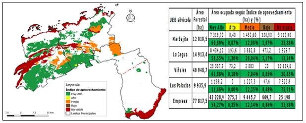
Of the company's forest area, 54.27 % has a very high level of potential to be used as raw material for obtaining biofuels and coincides mostly with the formation of pine forest. 76 % of its areas are catalogued with very high, high and medium IAv. The non-viable areas, 32.38 %, are distributed mainly in the coastal areas.
For the Viñales forestry UEB, more than 60 % of its areas are catalogued with a very high IAv, which is reasonable according to the relationship between the total area and the area occupied by productive forests, and 30.85 % is not viable, associated with the mogotes system with the category of special management. La Jagua and Marbajita show favorable areas, both to the south and north of the territory and specifically with very high IAv 60.89 and 56.55 % respectively. The non-viable areas correspond mainly to the strip belonging to the Sierra de los Órganos for La Jagua, and in Marbajita the extensive mangrove area.
In the case of Los Palacios, its extensive mangrove area, categorized as coastal protector, as well as the hydro-regulating strip of the tributaries present in the area, raise the non-viable areas of the UEB to 75.71 % with respect to its forest area, which indicates very low potential for residual biomass use, considering also the distant distribution of those with very high IAv.
Analysis of waste potential
With respect to obtaining the residual biomass potential, 32.13 % of the forest areas could not be considered in this analysis, as there are areas where the stands do not have all the information, since it refers to the current data of the areas at the time of completion of all the management work. Therefore, the database will be updated according to the planned activities to be carried out in the forest on an annual basis. Figure 4 shows the distribution of non-assessed areas by UEB and at the company level. It is positive that only 15.10 % of the areas not evaluated at the company level have a very high IAv, being in this sense the most affected UEB Marbajita with 40.49 %. Of the areas not evaluated at the enterprise level, 66.78 % have a nonviable IAv, and for Viñales and Los Palacios this ratio is 90.91 % and 83.73 % respectively (Figure 4).
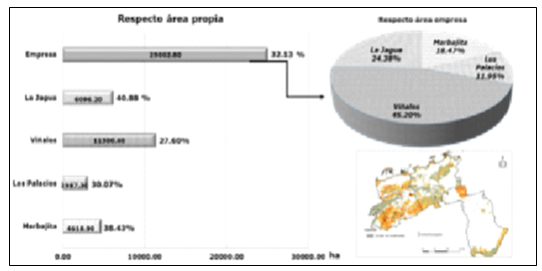
Fig. 4. - Forest area not evaluated in the analysis of forest residue potential, at the Company level and by silvicultural UEB
The evaluated area of the company reaches 67.86 % which includes 87 % of the producing forests and 91 % of the areas with very high harvesting index. The trend for the non-assessed area increases according to the low and non-viable IAv classification (Figure 5), which are mainly associated with special management forests, flora and fauna protection and other protective forests. However, as part of its strategy, the company should consider in its actions the systematic completion of the databases, as a way to take advantage of the residual biomass available in areas such as high and medium IAv.
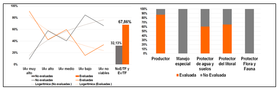
Fig. 5. - Forest area (TF) of the Company, evaluated (Ev) and not evaluated (NEv) in the analysis of forest residue potential, according to IAv and forest classification
Based on the ordering, it can be estimated that, for the evaluated areas, the company has a potential of 82,048.94t of residual biomass per year. This value will be updated annually in the database, by reapplying the methodology, according to the activities recommended for each year of the period. Figure 6 shows the distribution of this estimate at the company and silvicultural UEB level in the evaluated areas, considering the harvesting index (Figure 6).
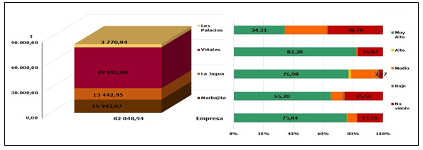
Fig. 6. - Estimated residual biomass (annual) at company and silvicultural UEB level and by IAv, in evaluated areas
The 75.84 % of the estimated residual biomass potential for the company is located in areas categorized with very high IAv. The Viñales forestry UEB has the highest residual biomass potential at the company level (48,892.08 t), and 82.20 % of this potential is located in areas with very high IAv. The case of the forestry UEB La Jagua is interesting, since its potential is 3.6 times lower than that of Viñales, but only 2.77 % is located in areas with non-viable IAv.
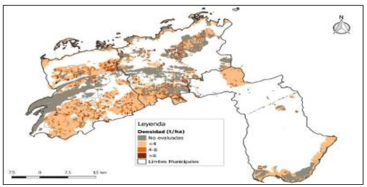
In the case of stands with a significant presence of residual potential, 76 % belong to the category of producing forests, mainly concentrated in the southern part of the UEB Viñales and part of the UEB La Jagua. The most representative values are in the range of less than 4 t/ha (Figure 7), present in the aforementioned areas and along the northern slope of the mogotes chain, where there are stands with higher values, which can reach 8 t/ha.
Stage III. Energy potential
In this and final stage of the methodology, the predominant species per stand are energetically characterized and the energy potential is estimated in ft.
Energetic characterization of the predominant species
Values of caloric power at 25 % moisture content were calculated, considering what was reported for dry forest biomass of pine, broadleaf and general forest as 21.52, 18.67 and 18.84 MJ/kg respectively (Guyat, M. et al., 2019). With these values, the corresponding calculations can be made, according to the predominant species group of the stand. In the case of the company, mainly pine species predominate.
Estimation of energy potential
Figure 8 shows the calculated annual residual biomass for each silvicultural UEB and Company. The dashed black line indicates the maximum possible values. The estimated value calculated for the company as a whole is 22,205 ft, 76 % of which is concentrated in areas with very high IAv and 65 % in the Viñales silvicultural UEB. In the UEB Los Palacios, it has a very low potential and the highest value, 375.40 ft, is obtained for areas with non-viable IAv. La Jagua, although with a lower total energy potential than Marbajita, with respect to its evaluated forest area, concentrates 77 % in areas with very high IAv and with respect to the company, these areas contribute 26 % (Figure 8).
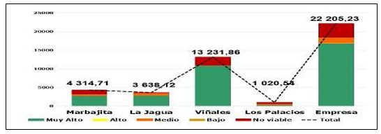
Fig. 8. - Energy potential (ft) calculated for each silvicultural UEB and Company according to zones classified by the Utilization Index (IAv)
These results reaffirm the need to take advantage of this energy potential to replace oil. As an example, we take the values estimated for the second edition3 of the Bioenergy Atlas (Curbelo, A. al., 2018), which indicate that, for the Province of Pinar del Río, 1,271.6 t/year of diesel are needed to cover the following activities of the food industry: meat: 419.9 t/year, dairy 760.7 t/year and bread 90.0 t/year. In the case of fuel oil, it is estimated that 306 t/year for the meat industry.
Figure 9 shows the energy potential per stand in the study area, where the stands with the highest values belong mainly to productive forests, with pine forest as the predominant species group. Of the defined areas, 67.6 % are in the range of less than 10 ft. The largest area of concentration is in the south of the municipality of Viñales, belonging to the UEB of the same name, which continues to extend to areas of the UEB La Jagua. These results reinforce that the areas with the greatest potential to be exploited by the company coincide with the energy potential of the waste generated. Despite the fact that the areas with the highest values are located in the northeastern and southeastern part of the UEB Los Palacios, the low availability of areas, their distance and in some cases low accessibility, place this UEB as the least likely for the energetic use of residual forest biomass (Figure 9).

The UEB Viñales is the administrative structure with the greatest potential in all aspects evaluated: harvesting index, residual biomass potential and energy potential, which enables the creation of collection centers and lower transportation costs. The UEB Los Palacios has the lowest harvesting possibilities, mainly due to the distance between its areas and accessibility.
CONCLUSIONS
The developed methodology is feasible for the planning, management and utilization of residual forest biomass for energy purposes in the Cuban forestry enterprise. It introduces indicators of waste and energy potential and the utilization index that allow the identification and classification of viable areas.
The application of the methodology in the EAF "La Palma" determines that 75.84 % of the annual residual biomass potential, estimated for the company, are located in the areas categorized with very high IAv and the annual energy potential is 22 205, 23 ft, which represents an advantage for the formulation of management strategies and use.
REFERENCIAS BIBLIOGRÁFICAS
ALTAMIRANO, A., SCHLEGEL, B., THIERS, Ó., MIRANDA, A., PILQUINAO, B., ORREGO, R., Y ROCHA, C. 2015. Disponibilidad y potencial energético de la biomasa del bosque nativo para el desarrollo de la dendroenergía en el centro-sur de Chile. Bosque , vol 36 no. 2, pp 223-237. Disponible en http://www.redalyc.org/articulo.oa?id=173141111008 [ Links ]
BROWN, S. 1997. Estimating biomass and biomass change of tropical forests. Department of Natural Resources and Environmental Sciences. University of Illinois, Urbana, Illinois, USA. Disponible en: http://www.fao.org/docrep/w4095e/w4095e07.htm#TopOfPage [ Links ]
CURBELO, A. et al. 2020. Oportunidades y limitaciones para el desarrollo de la Bioenergía por pequeños y medianos productores agrícolas. Informe, documento del Proyecto Bioenergía (GEF-PNUD), Cubaenergía y Estación Experimental Indio Hatuey. La Habana, 40 pp. [ Links ]
CURBELO, A. et al. 2018. Atlas de Bioenergía de Cuba. Sector Agropecuario y Forestal. Versión preliminar. CUBAENERGIA. ISBN 978 959 7231 07 3. [ Links ]
ESTRADA-TORRES, D., ORDÓÑEZ-PRADO, C., BUENDÍA-RODRÍGUEZ, E., y ÁGUILAR-SÁNCHEZ, P. 2017. Determinación de áreas aptas para el aprovechamiento de Biomasa Forestal Residual en la Umafor 1008: "El Salto", Durango, México. Revista de Aplicación Científica y Técnica, 1. Disponible en https://www.ecorfan.org/spain/researchjournals/Aplicacion_Cientifica_y_Tecnica/vol3num9 /Revista_de_Aplicacion_Cientifica_y_Tecnica_V3_N9.pdf#page=8 [ Links ]
GUYAT-DUPUY, MARÍA A., PLÁ-DUPORTÉL, MANUEL., y ARANGO-HERNANDEZ, MIRTA. 2019. Evaluación de la biomasa disponible para la generación de energía en Cuba. Revista Forestal Baracoa vol. 38 no. 2, mayo/agosto 2019, pp 712. Disponible en https://doi.org/10.5281/zenodo.4632274 [ Links ]
HERNÁNDEZ-RAMOS, JONATHAN; GARCÍA-CUEVAS, XAVIER; PERÉZ-MIRANDA, RAMIRO; GONZÁLEZ-HERNÁNDEZ, ANTONIO; y MARTINEZ-ÁNGEL, LUIS. 2020. Inventario y mapeo de variables forestales mediante sensores remotos en el estado de Quintana Roo, México. Madera y bosques, vol. 26 no.1, e2611884. Epub 30 de junio de 2020. Diponible en https://doi.org/10.21829/myb.2020.2611884 [ Links ]
RODRÍGUEZ MAINOR, ARIAS; et al. 2018. Ecuaciones alométricas para la estimación de la biomasa arbórea a partir de residuos de plantaciones de Gmelina arborea Roxb.y Tectona grandis L.f. en Guanacaste, Costa Rica. Revista Forestal Mesoamericana Kurú, vol. 15 (Suppl. 1), pp 61-68. Epub 19 de julio de 2019. Disponible en https://revistas.tec.ac.cr/index.php/kuru/article/view/3723 [ Links ]
TORRES-ÁLVAREZ, OSCAR; y PEÑA-CORTÉS, FERNANDO. 2011. Zonificación del potencial energético de la biomasa residual forestal en la cuenca del lago Ranco, Chile: Antecedentes para la planificación energética regional. Bosque (Valdivia), vol. 32 no.1, pp. 77-84. Disponible en https://dx.doi.org/10.4067/S0717-92002011000100009 [ Links ]
VIDAL, A. et al., 2001. Compendio de tablas para el pronóstico de Biomasa de Copa de Especies Forestales para diversos fines Económicos y Ambientales. Instituto de Investigaciones Agroforestales, La Habana, Cuba. [ Links ]
VILLELA-SUÁREZ, JUAN MARTÍN; AGUIRRE-CALDERÓN, OSCAR ALBERTO; TREVIÑO-GARZA, EDUARDO JAVIER; y VARGAS-LARRETA, BENEDICTO. 2018. Disponibilidad de residuos forestales y su potencial para la generación de energía en los bosques templados de El Salto, Durango. Madera y bosques , vol. 24 no.3, e2431529. Epub 01 de noviembre de 2018 Disponible en https://myb.ojs.inecol.mx/index.php/myb/article/view/e2431529 [ Links ]
Received: July 07, 2021; Accepted: October 27, 2021

